Estate Maps, 1750s-1900s

| Name: | Tait, James, fl. ca 1739-1797 (surveyor) Udny, Joseph, fl. ca 1770-1828 (draughtsman) |
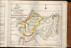
| Title: | The Plan of the farm of Kirkhill as posessed comprehending How-Gill-Cleughside, and Staffen-bigging with their shares of the Commonty of Bleise, Middle-rigg, Pleaknow, comprehending also the Mill, Mill-lands and Glebe of Wamphray |
| Imprint: | 1773 |
| Notes: | View abstract relating to this map. Courtesy of Annandale Estates through the Dumfries Archival Mapping Project |
| Zoom Into Map: | Click on the map to view in greater detail. |