Admiralty Charts of Scotland, 1795-1904
| Field | Content |
|---|---|
| Name: | Great Britain. Hydrographic Office |
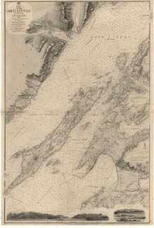
| Title: | Loch Linnhe, Southern Part |
| Imprint: | London : Hydrographic Office, surveyed 1860, corrections 1862, additions 1863, published 1862. |
| Pagination: | 1 map ; 1006 x 675 mm. |
| Shelfmark: | Admiralty Chart 2814a |
| Zoom Into Map: | Click on the map to view in greater detail. |