Map images
Search:
Maps home
>
Bathymetrical Survey of Fresh-Water Lochs, 1897-1909
Bathymetrical Survey of the Fresh-Water Lochs of Scotland, 1897-1909
Map details:
Field
Content
Map details:
Field
Content
Name:
Murray, Sir John (1841-1914)
Pullar, Laurence
Title:
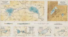
Lochs of Clunie & Drumellie; Loch Long & Pitlyal Loch; Rae Loch; Fingask, White & Black Lochs; Loch Bog; Monk Myre (Vol. 3, Plate 30)
Imprint:
[London] : Royal Geographical Society, surveyed 1903, published [1908].
Pagination:
6 maps on 1 sheet : col. ; 23.3 x 41 cm.
Shelfmark:
Map.B.1.c
Notes:
From:
Bathymetrical Survey of the Fresh-Water Lochs of Scotland
; constructed under the direction of Sir John Murray And Laurence Pullar during the years 1897 to 1909
Further information from the UK Lakes Portal:
Fingask Loch
Loch of Clunie
Loch of Drumellie or Marlee Loch
Monk Myre
Monk Myre
Rae Loch
Round Loch
Stormont Loch
Zoom into Map:
Click on the map to
view in greater detail
.
View text pages:
Loch of Clunie
Loch of Drumellie
Loch Long
Pitlyal Loch
Rae Loch
Fingask Loch
White Loch
Black Loch
Loch Bog (Stormont Loch)
Monk Myre