George Taylor and Andrew Skinner's Survey and maps of the roads of North Britain or Scotland, 1776
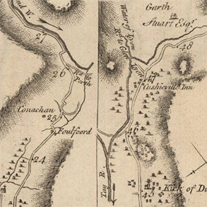
George Taylor and Andrew Skinner's volume, published in 1776, shows over 3,000 miles of roads in Scotland, across 61 plates, and was effectively Scotland's first road atlas. The roads were individually surveyed, and drawn at a scale of one-inch to the mile. Each page is divided into three vertical strips, showing the route along a particular road. The maps are a useful supplement to county mapping for showing the detail of places along particular major routes, and names of significant landowners are also included.
- Further information on this group of maps
- View the maps with a graphic index of Scotland
Preliminary pages:
- Title page
- Preliminary page [1] - Index of all the Cities, Towns and Villages...And An Index of the Cross Roads
- Preliminary page [2] - A list of Stages on the Great Roads...
- Preliminary map - A General Map of the Roads, made out of actual surveys taken by Geo Taylor & Andw Skinner
Maps of Scotland
- Plate 1 - The road from Edinburgh to Berwick upon Tweed
- Plate 2 - The road from Edinburgh to Cornhill by Greenlaw
- Plate 3 - The road from Lauder to Kelso; Road from Lauder to Jedburgh; Road from Edinburgh to Carlisle by Selkirk & Hawick.
- Plate 4 - The road from Edinburgh to Carlisle, Continued
- Plate 5 - Roads from Edinburgh to Moffat & Dumfries by Peebles, & also by Linton
- Plate 6 - The roads from Edinburgh to Moffat, Lochmaben & Dumfries by Peebles, & by Linton, Continued
- Plate 7 - The road from Edinburgh to Wigtoun and Whitehorn by Biggar, Lead hills and New Galloway, Continued from Page 5
- Plate 8 - The road from Edinburgh to Wigtoun and Whitehorn, Continued; The Road from Edinburgh to Lanark & Ayr by Douglass and Cumnock.
- Plate 9 - The road from Edinburgh by Douglas to Ayr and Stranrawer. Continued
- Plate 10 - The road from Edinburgh to Ayr & Stranrawer. Continued...
- Plate 11 - The road from Edinburgh, continued to Ayr by Hamilton
- Plate 12 - The road from Edinr, to Glasgow & Greenock & to Dunbarton & Inveraray. Continued
- Plate 13 - The road from Edinburgh to Glasgow, by Bathgate; Road from Edinburgh by Whiteburn, & Glasgow, continued to Inveraray.
- Plate 14 - The road from Edinburgh to Stirling, Tyndrum and Fort William...
- Plate 15 - The road from Edinburgh by Stirling, continued to Ft William...
- Plate 16 - The road from Edinburgh to Inveraray..., continued; The road from Dalmaly to Bunan...; The Road from Inveraray to Tarbet and Campbe
- Plate 17 - The road from Inveraray to Tarbet and Campbelton, continued
- Plate 18 - The road from Stirling by Crieff to Fort Augustus and Bernero
- Plate 19 - The Stirling road, continued from Dalnacardoch to Fort Augustus and on toward Bernero
- Plate 20 - The road from Stirling, continued by Fort Augustus to Bernero; The road from Dunkeld to Kenmore and Killin.
- Plate 21 - Road from Edinburgh to Thurso, and Johny Grots or Dungsby Head, by Perth, Dunkeld, Dalwhinnie, Inverness, &c..
- Plate 22 - The Road from Dalnacardoch to Aviemore.
- Plate 23 - The Road from Inverness to Tain.
- Plate 24 - The Road from Tain to Wick.
- Plate 25 - Road from Wick to Thurso.
- Plate 26 - The Road from Perth to Fort George.
- Plate 27 - The Road from Braemarr to Fort George.
- Plate 28 - The Road from Perth to Brechine.
- Plate 29 - The Road from Edinburgh to Fochabers by Huntly, continued from North Esk Bridge.
- Plate 30 - Road from Edinburgh, by Brechine, Banchory & Monymusk, continued to Old Rain, where it joins the Road from Aberdeen to Huntly; Road
- Plate 31 - The Road continued from Aberdeen by Old Meldrum, to Banff.
- Plate 32 - The Road from Banff to Inverness.
- Plate 33 - The Road from Edinburgh to Dundee, Aberbrothick, Montrose, Inverbervie & Stonehaven.
- Plate 34 - The Road from Edinburgh to Montrose & Stonehaven, continued; The Road from Pathead to Crail; The Road from Edinburgh to Cupar by Ke
- Plate 35 - The Road from Queensferry to Dumfermline, Culross, Clackmannan & Stirling; The Road from Queensferry to Borrowstouness, Falkirk & L
- Plate 36 - The Road from Prestonpans to N. Berwick; Road from Musselburgh to Dalkeith & Newbattle; The Road from Haddington to North Berwick e
- Plate 37 - The Road from Berwick to Hawick; The Road from Berwick to Dunse.
- Plate 38 - The Road from Biggar to Lanark; The Road from Peebles to Selkirk, by Fernalee Bridge.
- Plate 39 - The Road from Glasgow to Longtown by Hamilton, Douglass Mill & Moffat.
- Plate 40 - The Road from Elvanfoot to Dumfries; The road from Glasgow by Hamilton & Moffat. Continued to Longtown.
- Plate 41 - The Road from Glasgow to Ayr, & from Glasgow & Kilmarnock to Sanquhar & Dumfries
- Plate 42 - The Road from Glasgow to Kilmarnock, Sanquhar & Dumfries, Continued; The Road from Dumfries to Monyhive.
- Plate 43 - The Road from Port Patrick to Dumfries, Annan, & Longtown
- Plate 44 - The Road from Port Patrick to Dumfries, Annan, & Longtown, Continued; The road from Whitehorn to Glenluce
- Plate 45 - The road from Glasgow to Irvine; the road from Ayr to Machlin
- Plate 46 - The road from Greenock to Irvine and Ayr; the Road from Dumbarton to Row Kirk and Portencaple
- Plate 47 - The road from Glasgow to Paisly, Bieth & Kilwinning; the Road from Lanark to Hamilton; the Road from Lanark to Glasgow
- Plate 48 - The Road from Stirling to Glasgow; the Road from Stirling to Dumbarton
- Plate 49 - The road from Tarbet Inn to Crienlarach; the road from Crieff to Locherne Head; the Road from Crieff to Perth
- Plate 50 - The Road from St Andrews to Woodhaven & Newport; the road from Crail to St Andrews and Cupar
- Plate 51 - The Road from Dundee to Cupar and Dunkeld; the Road from Dunkeld to Ambleree
- Plate 52 - The Road from Dundee to Glammiss & Kirrimuir; the road from Dundee to Forfar
- Plate 53 - Road from Aberbrothick to Brechine; Road from Montrose to North Esk...; Road from Montrose to Laurence Kirk; Road from Laurence Kirk
- Plate 54 - The Road from Aberdeen to Braemarr & from Aberdeen to Durris & Banchory Ternan by the South side of Dee River
- Plate 55 - The Road from Charlestoun of Aboyne to Corgarff; the Road from Aberdeen to Monymusk & Alford; the Road from Aberdeen to Monymusk by
- Plate 56 - The Road from Aberdeen to Huntly; the Road from Aberdeen to Fraserburgh
- Plate 57 - The road from Aberdeen continued to Fraserburgh; the Road from Ellon to Peterhead; the Road from Peterhead to Fraserburgh
- Plate 58 - The Road from Banff to Peterhead by Strichen; the Road from Fraserburgh to Banff; the Road from Huntly to Banff
- Plate 59 - The Road from Fochabers to Aviemore; the Road from Nairn to Fort George
- Plate 60 - The Road from Inverness to Fort Augustus and Fort William and from Inverness to Glen Urquhart
- Plate 61 - A Plan of the Cross Roads in the Shires of Ross and Cromartie