Estate Maps, 1750s-1960s
| Field | Content |
|---|---|
| Name: | Robertson, P. J. |
| Title: | Plan of Englishtown, Fopachy, Kirktown and Inchberie. |
| Imprint: | 1824 |
| Pagination: | 1 manuscript map: col.; 154 x 100 cm. |
| Shelfmark: | Lovat207 |
| Notes: | Scale: 1:3,168 (25 chains = 6.25") Courtesy of Lovat Highland Estates and the North of Scotland Archaeological Society. |
| Zoom Into Map: | Click on the maps below to order images or view in greater detail. |
Map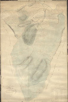
|
Reverse side
|
