There are 2,147 maps and plans in total listed on this website. This includes all of the material within the Scottish section of D. Alan Stevenson’s inventory from the 1950s, and the maps and plans from the 1990s acquisition. Although the Stevensons are most famous for lighthouse engineering, the archive covers many types of work. This pie chart shows the subjects of the maps and plans in the archive. The majority of the material relates to non-lighthouse work, predominantly on harbours, rivers and bridges.
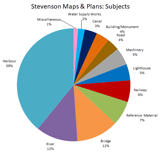
There are lots of other ways to divide up the plans. The original 1950s inventory was divided by place. The 1990s inventory separated the plans by subject. The achive could also be sorted based on the function each item served in the Stevenson firm, for example as reference plans, working drawings or proposals for presentation.
The work of the firm varied over time and between engineers. In the early period, under the leadership of Robert Stevenson, a much wider variety of projects were taken on. Plans of roads, bridges and railways by the Stevensons are generally from before 1850, perhaps reflecting a shift both in the type of infrastructural development over time and in the interests and specialisms of the family. Plans of water supply, buildings or monuments are often one off projects represented by only a few plans, but come from a whole range of dates throughout the firm's lifetime. Lighthouse, harbour and river work continued at a reasonably steady rate throughout the firm's existence, accounting for the bulk of the work done in any given period.
This page contains more information about the types of plans available in the archive, their general geographical and chronological span and the people who were involved in their creation.
Subjects
- Bridges
- Buildings/Monuments
- Canals
- Harbours
- Lighthouses
- Machinery
- Railways
- Reference Material
- Rivers
- Roads
- Water Supply Works
Bridges
The majority of the material related to bridges in the Stevenson collection is from the work of Robert Stevenson in the first half of the nineteenth century. Many of the earliest bridge plans in the archive are reference plans by other engineers from the late eighteenth century, including William Mylne’s plans for North Bridge in Edinburgh (MS.5849, 23-4).
Major Stevenson bridge projects represented in the archive include the Hutcheson Bridge in Glasgow, which was demolished in 1868 and replaced with Albert Bridge, proposals for bridges over the River Don near Aberdeen, Annan Bridge, Marykirk Bridge, bridges over the Almond Water and the Water of Leith in Edinburgh, Stirling Bridge and bridges over the Tay. The plans generally show very detailed, large scale representations of the bridge, often showing different views on different pages. They may be useful to historians interested in the history of bridge engineering and design. There are also a number of unattributed sketches of bridges in the archive that show different designs for bridges but do not explicitly refer to any geographic location (for example MS.5896, 19/ MS.5896, 25-6). These can be found through the text search.
A small number of plans relate to later bridge work by D. & T. Stevenson, including alterations made to North Bridge in Edinburgh in the 1870s.
View Plans and profiles of bridges, 18th-20th centuries to view images of Stevenson and other bridge plans.
Buildings/Monuments
There are two types of building plans in the Stevenson archive – those relating to industrial buildings and those relating to civic buildings in Edinburgh. Those relating to industrial buildings include farms and quarries but are predominantly of mills. This was likely associated with the family’s ongoing expertise in river engineering and the manipulation and movement of water. Geographically, these plans of industrial buildings range across all of Scotland and date from across the nineteenth century.
The majority of their work on civic buildings relates to building work in Edinburgh and dates form the first half of the nineteenth century. During this period, Edinburgh was undergoing significant infrastructural change associated with the construction of the New Town in the eighteenth century. Robert Stevenson was involved with various projects in the city centre, including the remodelling of the approach to Princes Street from the East around Calton Hill and the construction of the Melville Monument in St. Andrew Square in 1823.
The building and monument plans in the collection are generally very large scale plans depicting individual buildings or streets in significant detail. They may be useful in providing a very detailed representation of parts of central Edinburgh from the first few decades of the nineteenth century.
View Town Plans / Views, 1580s-1940s to view images of Stevenson and other building plans.
Canals
The majority of the canal plans in the archive relate to early canals built for inland transportation of goods and raw materials in the late-eighteenth and early-nineteenth centuries. Most of the plans from this era are by Robert Stevenson and relate to canal construction between Edinburgh and Glasgow and of the Caledonian Canal in the north-west.
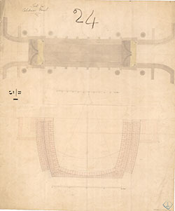
Robert was also heavily involved in the construction of early railways, which would quickly supersede canals as the most efficient method of moving goods. His early plans may therefore be useful in illustrating this transition, as the archive holds designs for both canals and railways in this period. There are even a number of plans from the 1810s showing a ‘proposed line for canal or railway’ (Acc.10706, 458-460).
Most of this material is either relatively small scale surveys showing multiple proposed canal routes by various engineers (often including those by Robert Stevenson), or very detailed cross-sections of specific technical aspects of canal design, predominantly specific locks.
A second smaller set of canal plans in the archive date from 1904 and illustrate plans by D. & C. Stevenson for a National Ship Canal stretching from Loch Lomond to the Firth of Forth. No canal construction plans date from the period 1850-1887 when David and Thomas Stevenson were in charge of the firm.
View Canal plans of Scotland, 18th-20th centuries to view images of Stevenson and other canal plans.
Harbours
Harbour plans represent almost 40% of the material in the Stevenson archive as a whole and are by far the most common type of plan. A massive increase in trade over the century meant that harbour expansion became a major preoccupation of Scottish engineering in general. The Stevensons were employed to work on numerous local harbours all over Scotland. Harbour work was a mainstay of the family business and to have occupied all family members during their time in the firm.
Harbour materials in the archive range from designs for small piers in local villages to major harbours of refuge and busy trading ports like Granton, Aberdeen, Fraserburgh, Peterhead and Glasgow.
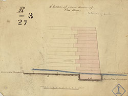
The majority of the plans are of specific harbours and range from town plans showing the outline of the harbour from above to specific cross sections of the design for harbour walls themselves. Larger scale harbour plans tend to be based on Admiralty charts and to show local marine conditions that may influence the proposed harbour. Many of the harbour plans show work in progress and seem to have been created for the use of the engineers’ office, showing alterations to the design, damage done to the work in progress by the sea and proposed repairs.
These materials depict some coastal towns and villages in Scotland in great detail. They are highly geographically diverse and include some early detailed maps of remote parts of the Highlands and Islands of Scotland. For some places, the development of the harbour can be traced over time through the archive as the Stevensons returned to the same location to make improvements and repairs to the earlier work of their ancestors.
View Town Plans / Views, 1580s-1940s to view images of Stevenson and other harbour plans.
Lighthouses
The Stevenson family are perhaps the most famous for their work in lighthouse design. From solitary, windswept reefs surrounded by open seas like Skerryvore and the Bell Rock, to the lights guiding vessels through busy rivers like the Clyde, the Stevensons built lighthouses around Scotland as engineers to the Northern Lighthouse Board from its foundation in 1786.
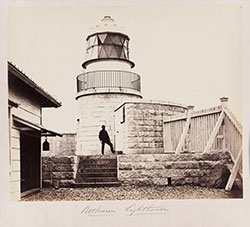
Although only a small proportion of the total archive – around 5% - the lighthouse material in the archive covers the whole period in which the Stevensons were operational and includes work by all members of the family. The majority are detailed plans relating to a specific lighthouse project, although some material displays the locations of lighthouses relative to one another and therefore covers a much wider area (MS.5886, 1).
Lighthouse material in the collection includes surveys of potential lighthouse sites, designs for towers, barracks and cottages, and technical diagrams relating to the lights themselves. Where there were diagrams of lights or lenses that were not linked to any specific lighthouse, they have been categorised as ‘machinery’ and can be found in the text-based search but not in the map-based search.
View Lighthouse plans and profiles, 1800s-1920s to view images of Stevenson lighthouse plans.
Machinery
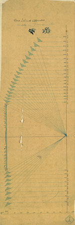
The Stevensons designed and developed various machines and instruments related to their work, throughout the century. They used this machinery to facilitate or improve the efficiency of the tasks they needed to accomplish as engineers, but they also devised and used instruments to undertake experiments and make measurements of their surroundings. The archive contains a reasonable number of visual representations of this type of work: as diagrams, as design specifications or as graphs showing observations or experimental results.
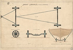
This material cannot usually be geographically located as it does not have a specific place associated with it. It is findable using the text-based search. These types of plans cover the whole period during which the Stevensons were active, although the subject matter covered changes with the specific research interests of the family members who were active at the time.
Plans of this type relate to Alan’s work on optics and lenses, Thomas’s research on waves and Charles’ experiments with fog signals, among various other things. There are also plans in the archive that were made by others which may have been used for reference or comparison. These include designs by well-known French light-makers Barbier & Turenne (Acc.10706, 578-9) and glassmakers Chance Bros and Co. (Acc.10706, 592/595/596/598).
Railways
Railway plans represent around 6% of the Stevenson archive. They primarily date from the 1820s and 1830s and are mostly concentrated around the south east of Scotland, including Edinburgh, the Lothians, Fife, Perth and Kinross and Angus. Plans of railways by the Stevensons generally relate to the transport of goods, particularly coal in the Lothians.
The plans are generally surveys showing proposed railway lines or branches. They often follow the proposed route relatively narrowly, showing little of the surrounding area but covering a relatively large geographic area. Many of the railway plans are particularly large in size, requiring a large surface area for consultation. Others are presented as booklets which separate the route into a number of smaller sections which are depicted on pages.
The archive also contains railway plans by other mid-century railway engineers, including James Jardine and Thomas Grainger and John Miller, possibly collected by the Stevensons for reference.
View Railway plans of Scotland, 18th-20th centuries to view images of Stevenson and other railway plans.
Reference Material
In addition to engineering plans relating to projects or proposals that the Stevensons were working on, the archive also contains reference plans. These are generally maps or plans that are not by the Stevensons. These plans include a number of Admiralty Charts and Ordnance Survey maps as well as plans by other leading engineers including Thomas Telford, James Abernethy and John and Alexander Gibb.
In general they are either the most accurate mapping of a specific area that was available at the time or document previous works that had been carried out on a specific place where the Stevensons were working. This is particularly the case for ongoing harbour and river works. Some of these reference plans have been annotated by the Stevensons in relation to the specific project for which they were used, while others are simply unmarked copies.
These maps and plans cover the widest range of dates in the archive. All of the maps and plans from before 1800 are reference plans. The collection of updated reference material was ongoing throughout the nineteenth century and into the twentieth century, extending as far as Admiralty Charts of the 1930s. The Stevensons did draft some of their own reference materials, predominantly surveys of coastal areas, but the majority of their reference material came from other authorities.
Rivers
Work on river improvements was an ongoing concern for the Stevensons and plans relating to river works represented 12% of the archive – the joint second most common subject. Although river material covers the whole period, the specific focus changes over time. Plans dating from the first half of the nineteenth century by Robert Stevenson tend to relate primarily to the River Tay. In the second half of the century under the management of David Stevenson, a much wider variety of rivers are represented, including work on the River Clyde. The rivers that are most extensively covered in the archive in general are the Tay (92 plans) and the Clyde (79 plans). Other rivers that are relatively well covered include the Almond Water (24 plans), the Tweed (18 plans), the South Esk (15 plans), the Water of Leith (12 plans), the Don (12 plans), the North Esk (12 plans) and the Conon (10 plans).
River plans in the Stevenson archive range from very detailed depictions of specific bends, islands or estuaries to plans covering rivers in their entirety. They also address a number of different purposes ranging from road and railway bridge placement and design, plans to improve the river for navigation and plans that were used to illustrate expert opinion on the physical movement and state of the river that was given in relation to legal disputes.
View River and water engineering plans of Scotland, 18th-20th centuries to view images of Stevenson and other river engineering plans.
Roads
Roads were also a minor interest of the Stevenson firm. Plans related to road work constitute 4% of the archive as a whole – around 80 plans. There are a few scattered plans of locations ranging from Thurso and Lerwick in the north, Dunbar in the south-east and routes along the shores of Loch Fyne. The vast majority of the road plans, however, are of Edinburgh. In particular, there are a number of plans concerning Robert Stevenson’s work to alter the eastern approach to Princes Street from Calton Hill and the construction of Waterloo Bridge in the 1810s.
The Stevensons also designed roads in conjunction with harbour developments, for example in Granton in the 1830s (MS.5848, 48-51). All but one of the plans showing roads date from the first half of the nineteenth century, before the death of Robert Stevenson in 1850. Where the road plans are credited to an individual – which does not happen very often – they are mostly attributed to Robert Stevenson.
Water Supply Works
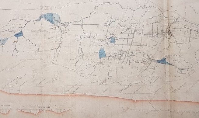
The smallest category of plans that is searchable using the online interface shows water supply works, which includes 41 records or 2% of the archive. These are mostly related to cities, particularly Edinburgh and Glasgow, and show reservoirs, aqueducts, sewage works and drainage schemes. Where smaller cities are represented they tend to be in the south-east, for example Kelso, Dunfermline, North Berwick and Dunbar.
The water supply works material varies in scale from citywide plans describing drainage to detailed plans for the construction of specific reservoirs. Each project tends to have only a small number of plans rather than an ongoing series of improvements and alterations as is often the case for river and harbour works. Nevertheless these plans may be useful for those interested in the history and development of particular towns or cities or in the history of water supply, public health and the urban experience in nineteenth-century Scotland.
View River and water engineering plans of Scotland, 18th-20th centuries to view images of Stevenson and other river engineering plans.
Back to list
