Roy Transcription Project Help Page
Welcome to the Roy Placename Transcription Project, organised by the National Library of Scotland and The British Library.
Please read this page before starting to transcribe any names.
This page contains the following information:
- Introduction - Roy's Military Survey of Scotland and Trancription Project
- Roy Placename Application
- Getting Started - Adding a 1st Transcription
- Adding a 2nd Transcription / Querying an Existing Transcription
- Additional Information
- Roy Transcription Forum
- Submitting corrections
Watch a help video on the Roy Placename Application. It covers getting started with an overview of the application, adding a first and then a second transcription, and finishes up with useful related additional information:
Introduction
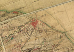
The Roy Military Survey of Scotland (1747-1755) is a uniquely important map in Scottish history and map-making. For many Highland areas, it is the most detailed and informative map that survives for the entire 18th century, whilst for all areas of the Scottish mainland, the only standard topographic map prior to the Ordnance Survey mapping in the 19th century. As well as being strikingly attractive to look at, the Roy Map is of value for researching many types of landscape history, including woodland, land-use, roads, settlements and antiquities. Read more about the Roy Map.
We hope that this placename transcription project will provide an enjoyable way of collaborating with others on a useful activity, to gather all of the names on the maps, and to release these as an open gazetteer. The National Library of Scotland will also set the Roy names up as a searchable interface, with links from the names to their locations on the maps.
This is a collaborative project organised by the British Library, who hold the original Roy mapping, and the National Library of Scotland.
Roy Placename Application
This application has been designed to work on a standard desktop or tablet, but not on a mobile phone. It has been tested successfully using Chrome, Edge and Firefox browsers on Windows and MacOS, but we are sorry that it does not work using Safari. The following sections explain more about our Roy application:
NLS reader loginTo use the application, you will need to join the Library. This is free and there is also a Quick online registration form. Read further details on how to register.
Left and Right Panels
The Roy Map is displayed on the left, and the Ordnance Survey (OS) 1st Edition mapping (1840s-1880s) is shown on the right. This is because we would like you to transcribe both the Roy Map name, as well as the later form of this name from the OS 1st Edition mapping (where it exists). This can help with inputting the correct Roy Map name transcription, as well as helping link the Roy Map name to later forms. Quite often, the Roy Map surveyors recorded names in a phonetic way, and without any systematic checking, so the OS name can provide a useful explanation of some Roy Map names in the final gazetteer.

On the far right there are two blue links to toggle between showing the Roy Map or OS Map as full screen.
Roy Map:- Highlands and Lowlands

The Roy Military Survey map is presented online as two layers- one for the Highlands and another for the Lowlands, overlapping in the Central Belt area. Switch between the Highlands and Lowlands layers using the upper left drop-down box.
- References (Strips and Sections)

The Roy Map is held as 38 strips of unequal size, each strip divided into a number of sections, subdivided into six further dissections, and mounted onto linen. The Roy Map reference for these strips and sections is shown to the lower right at zoom level 9 or higher. These may be useful in referring to a specific part of the map, or for organising work across a particular strip.
- Rotation
The Roy Map is orientated to what was magnetic north in the mid-18th century. You may find it easier to rotate the Roy Map so the text is horizontal. To do this, hold the [Alt] and [Shift] keys down, and drag with your cursor, or pinch with two fingers on a touch screen to rotate the map. Click/tap on the blue arrow to the upper right, or refresh the page to return to the default rotation.
The central transcriptions panel with the symbol ![]() to the upper right can be moved at any time by clicking and dragging on the box. This box will be used to record transcription entries. For more information, please read the next section on getting started.
to the upper right can be moved at any time by clicking and dragging on the box. This box will be used to record transcription entries. For more information, please read the next section on getting started.
Getting Started - Adding a 1st Transcription
On our Roy transcription page, you will notice there are 2 colours of polygons. We would like to record 2 independent transcriptions for each Roy name. This means, each name is being transcribed by 2 different people.
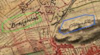
The colouring system works as follows:
- Names with 1 transcription have a green polygon.
- Names with 2 transcriptions have a blue polygon.
Please read the instructions below, to begin adding a 1st transcription or jump to adding a 2nd transcription / querying an existing transcription.
Zoom Levels

- To start transcribing names, please zoom into level 12 or higher. Most Roy Map names are only readable at higher zoom levels. We would suggest Zoom Level 14 gives the best setting in terms of text size and clarity.
Drawing Polygons

- On the Roy map (left-hand side), locate a name you wish to transcribe. To record a 1st transcription, the name on the map must have no polygon already drawn around it. (Hint: Remember to switch between the Highlands and Lowlands maps to find more names to transcribe).
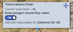
- From the central transcription panel, slide 'Draw Polygon around Roy Name' to 'On'.
(Note: Please be aware that after completing a transcription this slider returns to Off. For your next transcription, you will have to turn the 'Draw Polygon around Roy Name' back to 'On')
- Click around the Roy name to draw a polygon around it, clicking each time you change direction and double-clicking to close the polygon.
(Note: The polygon should enclose all of the text, with a little space around it, to ensure the whole name is clearly visible. Occasionally, polygons may overlap for names close together or extending over large features).
Adding Transcription Entries
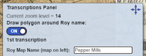
After closing the polygon, the central transcription panel should display as shown on the right. You can move this panel at any time by clicking and dragging.
- Roy Name: In the 1st box, please transcribe the exact name as written on the Roy Map (the left map) with the same capitalisation and spacing.
- (Optional Step) Other Roy Name: For the 2nd box, please enter an alternative name from the Roy Map by spelling out abbreviations or adding another possible transcription. If this is not relevant for the name you wish to transcribe, please leave this box blank and continue.
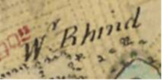
- Letters in superscript, usually indicating abbreviations, should be entered as they are in the 1st box on the transcription panel (under Roy Name). For example, in this case, 'Wr. Rhind' would be entered. The Other Roy Name should spell out the abbreviation, here being 'Wester Rhind'.

- A long 'S' should be entered as a capital S. As an example, 'BlackneSs' would be the Roy Name and lower case 'Blackness' would be the Other Roy Name.

- An upper case 'J', often at the start of a word, was often written as 'I'. Here 'Iohns Haven' would be the Roy Name and 'Johns Haven' would be the Other Roy Name.

- A lower case 'w' at the end of 'West Pittarow' may initially look like an 'n', but it is a 'w' and it should be entered as 'West Pittarow'.

- The letter 'k' within this name of 'Pikehorn' may initially resemble a 'z', being rather more ornate than a modern 'k', extending well below the line of text.
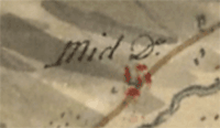
- The abbreviation 'Do.' for 'Ditto' was used to indicate a repeating name element from a nearby name. Please transcribe the the Roy Name for these exactly as written on the map (ie. as 'Mid Do.' in this case), but in the Alternative Roy Name, provide the complete name, by looking at the nearby name that the Ditto abbreviation relates to (in this case 'Mid Knockfin' - (view on map).
- The letter yogh (Ȝ or ȝ) looked like the letter z with an extra loop descending below the line, or the number 3 with a flat top-stroke and the lower half below the line. Please copy this character (ȝ) to clipboard and paste it into your transcription - copy ȝ to clipboard.
- The Scottish Handwriting.com website presents a selection of sample alphabets with letters. (If you scroll down on this page, the 18th century alphabet is most relevant to the Roy Map).
- If you are unsure about a particular letter or letter(s) and wish to indicate this in the transcription, you may add a [...] into the Roy Name field. However, if you wish to do the same under Other Roy Name, please try to provide a possible or suggested transcription. Sometimes, later Ordnance Survey mapping may give a clue to a likely letter or transcription. If you are really unsure about the transcription, we would suggest that you click on the red 'Cancel/Remove Feature' button, and use the Roy Transcription Forum to discuss the name.
If in doubt, leave it out!
- OS Name (map on right): In the 3rd box, please transcribe the same name from the OS map on the right by zooming in and out to look at both map scales. Please note that the right-hand panel will display the OS One-Inch Map at Zoom Level 14 or less, and the OS Six-Inch map will be displayed at Zoom level 15 or more. The map being viewed is shown in the White Box at the top of the right-hand panel.

(Important: Due to geographical inaccuracies on the Roy Map, you may have to move around the OS map to find the name as the same place may not appear in exactly the same position on the right-hand map). Use the link on the far right to show the Ordnance Survey (OS) Map as full screen. If you cannot find the equivalent OS name or are not sure if it is the same feature as on the Roy Map, please just leave this box blank and check the 'No OS Name for this Roy Name?' box below). - (Optional Step) No OS Name for this Roy Name?: Please check this box only if you cannot find an OS name that relates to the Roy name you are trying to transcribe. (Note: This is likely for places that were abandoned or disappeared between the mid-18th Century and the mid-19th Century).
- (Optional Step) Comments?: Please add any comments if you wish, to explain your transcriptions.
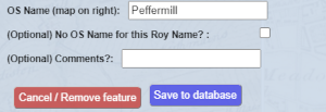
- When finished, double-check your transcription entries as these can not be altered afterwards. To save the transcription click on the blue 'Save to Database' button. Your transcription will be saved to our Roy Database and a confirmation message should appear.
If you change your mind and do not wish to enter the transcription for the polygon you drew, please click on the red 'Cancel/Remove Feature' button.
Adding a 2nd Transcription / Querying an Existing Transcription
- To start, make sure the 'Draw Polygon around Roy Name' slider is set to 'Off'.
- On the Roy Map, click on a green polygon.
(Note: For overlapping polygons, if you select more than 1 transcription, the popup box for the smaller polygon will appear. This will allow you to select other polygons with larger extents nearby. When adding a 2nd transcription for overlapping polygons, please read the popup box to ensure you are transcribing the correct name).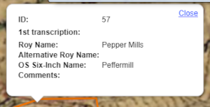
- A popup box will appear alongside the central transcription panel, showing the 1st transcription entry. To add a 2nd transcription, follow steps 5-10 from adding a 1st transcription.
(Important: Please only add a 2nd transcription to a polygon if you have not personally added the 1st transcription for the same name as we would like to gather transcriptions from two different people).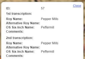
- Once you have completed the 2nd transcription and selected save to database, the polygon will turn blue. If you click on this polygon, the popup box will appear showing both the 1st and 2nd transcription entries.
The popup box also includes an ID for the transcription, from the example above, Pepper Mills' ID is 57. If you would like to contact us over a specific transcription, please quote the ID number and email maps@nls.uk.
Additional Information
Transcribed Names Total

The number of names that currently have a 1st and 2nd transcription by everyone, as well as the number of transcriptions you have added, is shown in the upper left. These numbers are divided into the Highlands and Lowlands, depending on which Roy Map layer you are viewing.
Dynamic URL
The URL in the address bar changes dynamically to show your particular map view (including the zoom level, latitude and longitude, and Highlands/Lowlands). You may save or bookmark this URL at any time if you wish to return to the same specific place, or send the link to others.
For example, this is a specific URL for the application zoomed in on Perth: https://maps.nls.uk/transcriptions/roy/maps/#zoom=14&lat=56.3982&lon=-3.4308&layers=0
Error reporting
This application displays dynamic maps and polygons containing transcriptions from the National Library of Scotland's web servers. When you click on the 'Save to database' button on the Transcriptions Panel, your transcription is sent to these web servers, saved, and the updated polygon and transcription should then be displayed back in the application. In the event of network or web server problems, the dynamic maps and polygons may not appear, and the 'Save to database' function may fail. In the first instance, we would suggest completely refreshing the application by reloading the URL in your browser address bar and try to carry on transcribing. However, if the maps or transcriptions still fail to appear, or the application fails to work as you are expecting, please stop using it, e-mail us at maps@nls.uk and we will aim to fix it as soon as possible.
Search for a specific Transcription ID

You can search to locate a specific Transcription ID using the input box to the upper right. Transcription IDs should take the form "L66", "H304", etc. When you click on 'Enter', if a matching ID is found, the map should zoom to this specific transcription and display it in a popup box.
Roy Transcription Forum
For the Roy Transcription Project, we have also set up a forum for participants to share their thoughts about placenames, comment on transcriptions and ask others for help.
To join the forum, you will have to sign-up with your email address, create your own password, and then wait for approval. Once approved you will be able to login, view and add posts to the forum.
Submitting corrections
If you require any corrections to your transcriptions, such as removing a duplicate polygon or deleting or editing an entry, please complete this form. Once received, we will update your request as soon as possible. Thank you in advanced for notifying us of any issues, and please submit this form anytime you require a correction to be made.
View Related Pages:
If you have any other questions, please contact us at maps@nls.uk.
