|
1500 |
|
| [1558-1566] - Anon - Scotia: Regno di Scotia |
| [1572] - Tommaso PORCACCHI - Scotia |
| [1573] - Abraham ORTELIUS - Scotiae Tabula |
| [1573] / 1905 facsimile - Abraham ORTELIUS - Scotiae Tabula |
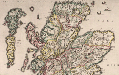
| [1578] - Bishop John LESLIE - Scotiae regni antiquissimi accurata descriptio |
| 1579 - Philippe GALLE - Scotiae descriptio |
| 1579 - Philippe GALLE - Septentrionalium regionum descriptio |
| 1580 - Johann Natalius Metellus SEQUANUS - Scotia = Schotlandt = Escosse |
| ca. 1583 - Philippe GALLE - Scotiae descriptio |
| ca. 1585 - Philippe GALLE - Scotiae descriptio |
| 1590 - Scotiae nova et accurata descriptio |
| 1592 - Henricus NAGEL - Scotiae Tabula |
| [1595] - Gerhard MERCATOR - Scotia Regnum |
| [1595] - Gerhard MERCATOR - Scotia Regnum [Northern Scotland] |
| [1595] - Gerhard MERCATOR - Scotia Regnum [Southern Scotland] |
| 1598 - P.M. MARCHETTI - Scotiae descriptio |
| 1598 - P.M. MARCHETTI - Scotiae descriptio |
| 1598 - P.M. MARCHETTI - Septentrionalium regionum descriptio |
| 1598 - Barent LANGENES - Scotia |
| 1599 - Giovanni BOTERO - Scotiae descriptio |
| 1599 - Giovanni BOTERO - Scotiae descriptio |
|
|
1600 |
|
| 1601 - Abraham ORTELIUS - Scotia |
| 1601 - Abraham ORTELIUS - Scotia |
| 1602 - Abraham ORTELIUS - Scotia |
| 1602 - Philippe GALLE - Scotia |
| 1604 - Abraham ORTELIUS - Scotia |
| 1604 - Abraham ORTELIUS - Scotia |
| 1606 - Abraham ORTELIUS - Scotiae tabula |
| [1607] - William HOLE - Scotia Regnum. |
| 1607 - William HOLE - Scotia regnum |
| 1607 - Jodocus HONDIUS - Scotia |
| 1609 - Abraham ORTELIUS - Scotia |
| 1609 - Abraham ORTELIUS - Scotia |
| [1610] - John SPEED - The Kingdome of Scotland |
| 1612 - Abraham ORTELIUS - Scotiae tabula |
| 1612 - Abraham ORTELIUS - Scotiae tabula |
| 1612 - Petrus BERTIUS - Scotia |
| 1613 - Gerhard MERCATOR - Scotia regnum |
| 1616 - Petrus BERTIUS - Scotia |
| 1618 - Jodocus HONDIUS - Scotia |
| 1618 - Jodocus HONDIUS - Scotia |
| 1618 - Jodocus HONDIUS - Scotia septentrion[al] |
| 1618 - Jodocus HONDIUS - Scotia septentrion[al] |
| 1618 - Jodocus HONDIUS - Scotia australis |
| 1618 - Jodocus HONDIUS - Scotia australis |
| 1623 - Giovanni Nicolo DOGLIONI - Scotia |
| 1627 - John SPEED - The Kingdome of Scotland |
| 1627 - Pieter van den KEERE - The South pt of Scotland wherin are contayned Edinbrough, St. Andrew and Glasco Archbisho |
| ca. 1627 - Pieter van den KEERE - The Eastern part of Scotland wherin ther [sic] are diuers Shires and the Vniversity of Aberdyn |
| 1628 - Jan JANSSON - Schotia |
| 1628 - Jan JANSSON - Scotia meridionalis |
| 1628 - Jan JANSSON - Scotia septentrionalis |
| 1630 - Gerhard MERCATOR - Scotia regnum |
| 1630 - Gerhard MERCATOR - [Scotiae Regnum : Meridionalis] |
| 1630 - Gerhard MERCATOR - Scotiae Regnum |
| 1630 - Jan JANSSON - Schotia |
| ca. 1630 - The Kingdome of Scotland |
| ca. 1630 - Abraham GOOS - Scotia meridionalis |
| ca. 1630 - Abraham GOOS - Scotia septentrionalis |
| 1630 - Johannes CLOPPENBURG - Scotiae Regnum |
| 1630 - Johannes CLOPPENBURG - [Scotiae Regnum Meridionalis] |
| 1630 - Johannes CLOPPENBURG - Scotia regnum |
| 1631 - Jan JANSSON - Scotia Septentrionalis |
| 1631 - Jan JANSSON - Scotia Meridionalis |
| 1632 - John SPEED - The Kingdome of Scotland |
| 1632 - Pieter van den KEERE - The South pt of Scotland wherin are contayned Edinbrough, St. Andrew and Glasco Archbisho |
| 1632 - Pieter van den KEERE - The Southren parte of Scotland, wherin is ye Strange Lake Lomund |
| 1632 - Pieter van den KEERE - The Eastern part of Scotland wherin ther are divers Shires and the Vniversity of Aberdyn |
| 1632 - Pieter van den KEERE - Part of Scotland, it is called of the inhabitance of Stranauerre with his borderers |
| 1632 - Pieter van den KEERE - The Iles of Hebrides wiz ther borderers |
| [1635] - Willem BLAEU - Scotia Regnum. |
| [1636] - Henricus HONDIUS - Scotiae pars septentrionalis |
| [1636] - Henricus HONDIUS - [southern Scotland] |
| 1641 - Hendrik HONDIUS - Scotiae pars septentrionalis |
| 1641 - Gerhard MERCATOR - [Scotiae Regnum : Meridionalis] |
| [ca. 1644] - Thomas JENNER & Wenceslaus HOLLAR - The north-part of England and the south-part of Scotland |
| 1644 - Wenceslaus HOLLAR - The North = part of England and the South = part of Scotland ca. 1644 [part of Quartermasters’ map] |
| 1646 - John SPEED - The Kingdome of Scotland |
| 1646 - John SPEED - The Kingdome of Scotland |
| 1648 - Philippe BRIET - Le Royaume Descosse |
| 1648 - Philippe BRIET - Le Royaume Descosse |
| 1648 - Philippe BRIET - Le Royaume de la Grande Bretaigne |
| 1648 - Jan JANSSON - Scotia meridionalis |
| 1648 - Jan JANSSON - Scotia septentrionalis |
| 1648 - Nicolas SANSON - Escosse Royaume |
| 1653 - Robert GORDON - Scotia antiqua... |
| [1654] - Robert GORDON - Scotia Regnum... |
| [1654] - Joan BLAEU - Atlas of Scotland (Atlas novus, volume V) |
| 1654 - Robert GORDON - Scotia antiqua : qualis priscis temporibus, Romanis praesertim, cognita fuit quam in lucem eruere conabatur |
| 1655 - G.M. TURRINI - Scotiae descriptio |
| 1655 - G.M. TURRINI - Scotiae descriptio |
| [1659] - Joannis JANSSON - Extima Scotiae.. |
| [1659] - Joannis JANSSON - Scotiae Provinciae intra flumen Taum.. |
| [1659] - Joannis JANSSON - Scotiae Provintiae inter Taum fluvium.. |
| [1659] - Joannis JANSSON - Lochabria... |
| [1659] - Joannis JANSSON - Tabula Leogi et Haraiae.. |
| [1659] - Joannis JANSSON - Lorna, Knapdalia, Cantire, Jura.. |
| ca. 1660 - Scotia |
| 1661 - Pierre DUVAL - Escosse |
| 1661 - Pierre DUVAL - Escosse |
| ca. 1661 - Pierre DUVAL - Escosse |
| [1662] - Joan BLAEU - Atlas of Scotland (Atlas Maior, Volume VI) |
| 1662 - SPEED, JOHN - The Kingdome of Scotland |
| 1662 - John SPEED - The Kingdome of Scotland |
| 1665 - Nicolas SANSON - L'Escosse Royaume... |
| 1665 - Nicolas SANSON - L'Escosse deca le Tay... |
| 1665 - Nicolas SANSON - L'Escosse dela le Tay.. |
| 1665 - Nicolas SANSON - Les Isles Orcadney.. |
| 1667 - Scipion BANCA - Scotiae descriptio |
| [1673] - Richard BLOME - A mapp of the Kingdome of Scotland. |
| 1676 - John SPEED - The Kingdome of Scotland |
| 1676 - John SPEED - The Kingdome of Scotland |
| 1678 - Wilhelm PFANN - Scotia |
| 1679 - Robert GREENE - New map of Scotland with the roads |
| 1679 - Pierre DUVAL - Scotia |
| 1680 - John GARRETT - The Kingdome of Scotland |
| [ca.1680] - Frederik DE WIT - Scotia Regnum... |
| 1681 - Jonas MOORE - Scotland |
| 1683 - Allain MANESSON-MALLET - Escosse |
| 1683 - Allain MANESSON-MALLET - Escosse |
| 1683 - Allain MANESSON-MALLET - Royaume d'Ecosse |
| ca. 1683 - Allain MANESSON-MALLET - Is de Fero de Scheland, Orknay et Hebrides |
| ca. 1683 - Allain MANESSON-MALLET - Is de Fero de Scheland, Orknay et Hebrides |
| ca. 1683 - Allain MANESSON-MALLET - Is de Fero de Scheland, Orknay et Hebrides. |
| 1684 - Royaume d'Esosse |
| 1687 - Pierre DUVAL - Les Isles Britaniques, ou sont les Royaumes d'Angleterre et d'Escosse .. |
| [1687] - Robert MORDEN - A mapp of Scotland made by R. Gordon |
| ca. 1688 - Robert MORDEN - Scotiae Nova Descriptio |
| 1689 - Jean Baptiste NOLIN & Vincenzo CORONELLI - Le Royaume d'Escosse.. |
| 1689 - Nicolaes VISSCHER - Exactissima Regni Scotiae tabula tam in septentrionalem et meriodionalem quam in minores earundem provincias, insulasq... |
| [1689] - Nicolaes VISSCHER - Exactissima Regni Scotiae Tabula tam in septentrionalem et meriodionalem quam in minores earundem provincias, insulasq... |
| 1690 - Jean Baptiste NOLIN - Royaume d'Ecosse divisee en provinces : suivant les nouvelles observations |
| 1690 - Nicolaes VISSCHER - Exactissima Regni Scotiae Tabula cam in septentrionalam et meridionalem quam in minores earumdem provincias, insulasq .. |
| 1690 - Johann Baptist HOMANN - Scotiae Regnum = Koenigreich Schottland |
| 1690 - Pierre DUVAL - Scotia |
| 1693 - Robert GORDON - Scotia regnum cum insulis adjacentibus |
| 1695 - Robert MORDEN - Scotland |
| [1695] - Robert MORDEN - Scotland. |
| ca. 1695 - Robert MORDEN - Scotland |
| 1695 - Robert MORDEN - Scotland |
| [1696] - Vincenzo CORONELLI - Scotia : parte settentrionale ; parte meridionale |
| 1697 - Vincenzo CORONELLI - Scotia : parte settentrionale = Scotia parte meridionale |
| [1697] - Carel ALLARD - Novissima Regni Scotiae septentrionalis et meridionalis tabula. |
|
|
1700 |
|
| 1700 - [Ecosse] |
| ca. 1700 - T Koningryk van Schotlandt, in zyne Zuider, en Noorder deelen verdeelt |
| [1701] - Hermann MOLL - Scotland |
| 1702 - Johann Ulrich MULLER - Scotia |
| 1705 - Peter SCHENK - Regnum Scotiae : seu pars septent ; Magnae Britanniae, divisa in Scotiam septent et australem porro autem incomit.. |
| 1705 - Jan JANSSON - Extimae Scotiae pars Septentrionalis in qua Provinciae Rossia, Sutherlandia, Cathenesia, et Strath-Naverniae |
| ca. 1705 - Robert MORDEN - A New Mapp of Scotland, the Western, Orkney, and Shetland Islands |
| ca. 1705 - Jan JANSSON - Scotiae provinciae inter Taum Fluvium, et septentrionalis oras Angliae |
| 1707 - Pieter van der AA - Scotia |
| 1708 - Peter SCHENK - Novissima Regni Scotiae septentrionalis et meridionalis tabula.. |
| [1708] - Hermann MOLL - The north part of Great Britain |
| [1708] - Zacharias CHATELAIN - Nouvelle carte d'Ecosse |
| ca. 1710 - Nicolas SANSON - Le Royaume de Escosse divisee en ses parties meridionale et septentrionale |
| ca. 1710 - Jan GOEREE - Comes limitis Saxonici per Britanniam ejusque insigniae |
| ca. 1710 - Sutton NICHOLLS - A new map of North Britain or Scotland containing all the cities and market towns |
| [ca.1710] - Johann Baptist HOMANN - Magnae Britanniae pars septentrionalis |
| 1714 - Hermann MOLL - The north part of Great Britain called Scotland |
| 1714 - Hermann MOLL - The north part of Great Britain called Scotland : with considerable inprovements [sic] and many remarks not extant in any map |
| 1715 - Nicolas SANSON - A new and exact mapp of Scotland, or North Britain |
| 1718 - Hermann MOLL - A pocket companion of ye roads of ye north part of Great Britain called Scotland |
| 1718 - Nicolaes VISSCHER - Exactissima Regni Scotiae tabula tam in septentrionalem et meridionalem quam in minores earumden provincias |
| ca. 1718 - Christoph WEIGEL - Scotia Cambdeni et Sibbaldi |
| 1722 - Andrew JOHNSTON - New map of the [north / south] part of Scotland |
| 1725 - Frederick de WIT - Scotia Regnum divisum in partem septentrionalem et meridionalem.. |
| 1727 - Pieter van der AA - Scotia |
| 1727 - Pieter van der AA - Scotia |
| 1727 - Pieter van der AA - Scotia |
| 1730 - Hermann MOLL - A new and correct map of Scotland & the Isles, containing all ye cities, market towns, boroughs, &c.. |
| ca. 1730 - Hermann MOLL - The north part of Great Britain called Scotland... |
| [1731] - Clement LEMPRIERE - A description of the highlands of Scotland... |
| 1731 - Thomas BAKEWELL - The North Part of Great Britain called Scotland |
| 1731 - BOWLES, THOMAS - A new mapp of Scotland or North Britain with considerable improvements according to the newest observations |
| 1734 - John COWLEY - A new map of North Britain with the islands.. |
| 1734 - John COWLEY - A display of the coasting lines of six several maps of North Britain . . . . |
| 1734 - John COWLEY - A display of the coasting lines of six several maps of North Britain . . . . |
| 1734 - John COWLEY - A new map of north Britain with the islands thereunto belonging ... |
| 1734 - John COWLEY - A new map of north Britain with the islands thereunto belonging ... |
| 1734 - Henri DU SAUZET - Ecosse meridionale |
| 1734 - Henri DU SAUZET - Escosse septentrionale |
| ca. 1735 - Matthaeus SEUTTER - Nova et accurata totius Regni Scotiae.. |
| ca. 1740s? - Richard COOPER - A Skitch [sic] of part of the Highlands of Scotland. |
| 1740 - Johannes CÓVENS - Novissima Regni Scotiae septentrionalis et meridionalis tabula ... |
| ca. 1740 - La Scozia |
| 1741 - Nicolas SANSON - L'Escosse dela le Tay : divisee en toutes ses provinces : tirees des cartes particulieres de Timot. Pont, de R. Gordon a Straloch etc. |
| 1741 - Nicolas SANSON - L'Escosse royaume en ses principales parties, qui sont deca et dela le Tay et chaque partie subdivisee en leurs provinces qu'ils appellant shirif-domes, stewarties &c... |
| [1744] - Alexander BRYCE - A map of the north coast of Britain.. |
| 1744 - Richard William SEALE - A Map of the Kingdom of Scotland from the latest and best observations, for Mr. Tindal's Continuation of Mr. Rapin's History |
| 1744 - Emmanuel BOWEN - A new and accurate map of Scotland |
| [1745] - Hermann MOLL - Scotland divided into its shires |
| 1745 - John ELPHINSTONE - A new & correct map of North Britain |
| 1745 - Nicolas SANSON - A new and exact mapp of Scotland or North-Britain |
| 1745 - Henry OVERTON - The kingdom of Scotland divided into the North and South parts ... |
| 1745 - John ELPHINSTONE - A new & correct Mercator's map of North Britain .. |
| 1745 - Andrew RUTHERFORD - An Exact Plan of His Majesty's Great Roads through the Highlands of Scotland. |
| 1746 - New mapp of Scotland or North Britain with considerable improvements according to the newest observations |
| 1746 - George Louis LE ROUGE - L'Eccosse suivant les nouvelles observations publies a Londres en 1735 par Bowles |
| 1746 - Thomas WILLDEY - A map of the King's Roads, Made by his Excellency General Wade in the Highlands of Scotland.. |
| 1746 - Thomas WILLDEY - A map of the King's Roads, Made by his Excellency General Wade in the Highlands of Scotland.. |
| 1746 - Emmanuel BOWEN - A new & accurate map of Scotland or North Britain. Drawn from surveys & most approved maps & charts; exhibiting the King's Roads, &c. |
| 1746 - George-Louis LE ROUGE - L'Ecosse suivant les nouvelles observations publies a Londres en 1735 par Bowles |
| 1746 - Richard COOPER - A map of His Majesty's roads from Edinburgh to Inverness, Fort Augustus & Fort William and of the countries adjacent thereto ... dedicated to ... William Augustus, Duke of Cumberland ... |
| ca. 1746 - Thomas KITCHIN - A map of the King's roads, made by his Excellency General Wade in the Highlands of Scotland: from Sterling to Inverness with the adjacent counties &c. |
| 1747-55 - William ROY - Military Survey of Scotland |
| 1748 - George BICKHAM - A map of the North part of Great Britain, called Scotland |
| 1748 - Gilles Robert DE VAUGONDY - Royaume d'Ecosse divise en provinces |
| 1748 - George-Louis LE ROUGE - Le Royaume d'Ecosse : Divise en ses parties Meridionale et Septentrionale |
| 1749 - Thomas JEFFERYS - Scotland |
| 1750 - James DORRET - A general map of Scotland and islands thereto belonging |
| 1751 - James DORRET - [North] A correct map of Scotland from new surveys.In two sheets (North and South) with W part S sheet missing.1751 |
| 1751 - James DORRET - [South] A correct map of Scotland from new surveys.In two sheets (North and South) with W part S sheet missing.1751 |
| 1751 - James DORRET - A correct map of Scotland from new surveys |
| 1751 - Gilles Robert DE VAUGONDY - Le Royaume d'Ecosse divisee en shires ou comtes |
| 1751 - James DORRET - A correct map of Scotland from new surveys |
| ca. 1753 - Tabula Geographica Scotiae, etc |
| 1755 - Isaak TIRION - Nieuwe Kaart van't Noorder Gedellte van Grootbritannie behelzende Het Koningryk Schotland. |
| ca. 1756 - Leonhard EULER - Tabula Geographica Scotiae ... |
| 1757 - J.N. BELLIN - Carte reduite des Isle Britanniques |
| 1758 - Thomas PHINN - A new and accurate map of Scotland ... in which are delineated the routes of the several armies in 1745 & 1746 |
| 1760 - George-Louis LE ROUGE - L'Ecosse suivant les nouvelles observdtiont.[sic] |
| ca. 1760 - Thomas BOWLES - A new mapp of Scotland or North Britain with considerable improvements according to the newest observations |
| 1761 - James DORRET - An accurate map of Scotland |
| 1761 - James DORRET - An accurate map of Scotland drawn from all the particular surveys.. |
| 1762 - Gilles R. DE VAUGONDY - L'Ecosse |
| 1764 - J.N. BELLIN - Carte de l'Ecosse |
| 1764 - Andrew DURY - [Map of northern Scotland with Orkney] |
| 1764 - Andrew DURY - [Map of Inner and Outer Hebrides] |
| 1764 - Andrew DURY - [Map of south west Scotland] |
| 1764 - Andrew DURY - A map of Scotland |
| 1765 - Tobias Conrad LOTTER - Nova et Accurata totius Regni Scotiae, secundum omnes provincias et adjacentes insulas ... |
| 1765 - Louis BRION DE LA TOUR - L'Ecosse, dressee conformement aux observations astronomiques et aux itineraires |
| 1766 - Louis BRION DE LA TOUR - L'Ecosse, dressee conformement aux observations astronomiques et aux itineraires |
| 1766 - Louis BRION DE LA TOUR - L'Ecosse, dressee conformement aux observations astronomiques et aux itineraires |
| 1767 - William PALMER - A new and accurate map of Scotland, divided into shires from the most authentick surveys |
| ca. 1767 - Thomas JEFFERYS - Scotland |
| 1768 - Emmanuel BOWEN - Naauwkeurige Kaart van Schotland. Volgens de Klootachtige gedaante der Aarde |
| 1769 - Emanuel BOWEN - A map of North Britain or Scotland, from the newest surveys & observations |
| 1770 - Philippe de PRETOT - L'Ecosse, conforme aux itineraires et assujettie aux observations astronomique les plus recentes |
| 1771 - Thomas KITCHIN - Scotland with the roads, from the latest surveys |
| 1771 - Rigobert BONNE - Carte du Royaume d'Ecosse ... |
| 1771 - Rigobert BONNE - Carte du Royaume d'Ecosse |
| [1773] - Thomas KITCHIN - A new and complete map of Scotland and islands thereto belonging |
| 1774 - Samuel DUNN - Scotland, and its islands; : or the North part of Great Britain, divided into shires |
| 1774 - RICHARD OF CIRENCESTER - Mappa Britanniae Septentrionalis Faciei Romanae, secundum fidem monumentorum |
| 1775 - Andrew & Mostyn ARMSTRONG - A new map of Scotland, with the distances on the post, & other roads in measured miles, laid down from actual surveys ... |
| 1775 - Jean PALAIRET - Scotland |
| 1776 - George TAYLOR and Andrew SKINNER - A General Map of the Roads, made out of actual surveys |
| 1776 - Antonio ZATTA - Il Regno di Scozia .. |
| 1776 - Antonio ZATTA - Il Regno di Scozia ... |
| 1777 - Thomas PENNANT – A map of Scotland .. |
| 1778 - Gilles Robert DE VAUGONDY - L'Ecosse divisee en Shires ou Comtes |
| 1778 - Thomas KITCHIN - North Britain or Scotland divided into its countries : Corrected from the best surveys & astronomical observations |
| 1778 - Richard MARSHALL - A new mapp of North Britain or Scotland. Containing all the cities and market towns, with the roads from town to town ... |
| 1778 - Gilles R. DE VAUGONDY - L'Ecosse |
| 1779 - Antonio ZATTA - La Scozia Settentrionale, divisa nelle sue contee particolari ... |
| 1779 - Augusto RABATTA - Scozia meridionale anticamente Codanonia |
| 1779 - Augusto RABATTA - Scozia settentrionale anticamente Codanonia |
| 1780 - Joseph de la PORTE - Carte du Royaume d'Ecosse |
| ca. 1780 - James MEUROS - A new and accurate map of Scotland divided into shires from the most authentick surveys |
| 1782 - John KNOX - A commercial map of Scotland |
| 1782 - Daniel LIZARS - Map of Scotland, with the principal roads ... |
| 1782, 1783 - John ANDREWS - Andrews's new and accurate travelling map of the roads of Scotland |
| 1783 - John AINSLIE - Ainslie's travelling map of Scotland shewing the distances from one stage to another |
| 1783 - AINSLIE, JOHN - Ainslie's travelling map of Scotland shewing the distances from one stage to another |
| 1784 - A commercial map of Scotland; with the roads, stages, and distances brought down to the present time |
| 1784 - Thomas KITCHIN - Scotland. Divided into its counties from the latest surveys |
| 1785 - James ANDERSON - A new map of Scotland; : the Hebrides and western coasts in particular being laid down from the best authorities corrected by late observations |
| 1786 - Thomas CONDER - A new map of the middle part of Scotland ... drawn from the best authorities |
| 1786 - Thomas CONDER - A new map of the Southern part of Scotland ... drawn from the best authorities |
| 1786 - Samuel DUNN - Scotland, and its islands; : or the North part of Great Britain, divided into shires |
| 1787 - Franz Anton SCHRAEMBL - Karte von Scotland |
| 1787 - BONNE, RIGOBERT - Carte de l'Ecosse |
| 1787 - Rigobert BONNE - Carte de l'Ecosse |
| 1788 - John KNOX - A commercial map of Scotland; with the roads, stages, and distances brought down to the present time |
| 1789 - John AINSLIE - Scotland, drawn from a series of angles and astronomical observations.. |
| 1789 - A new and correct map of Scotland, drawn from the latest surveys of that part of Great Britain |
| 1789 - Franz Johann Joseph VON REILLY - Das Irische und Kaledonische Meer mit seinen Inseln |
| 1789 - Franz Johann Joseph VON REILLY - Das Koenigreich Scotland, etc |
| 1790 - Jean Denis BARBIE DU BOCAGE - L'Ecosse avec ses isles |
| 1790 - Robert CAMPBELL - A new and correct map of Scotland or North Britain, with all the post and military roads |
| 1790 - Robert CAMPBELL - A new and correct map of Scotland or North Britain with all the post and military roads |
| 1790 - Robert CAMPBELL - A new and correct map of Scotland or North Britain with all the post and military roads |
| 1790 - [Scotland and Orkney, Shetland and Faeroe Islands] |
| [1790] - J. MURDOCH - A map of Scotland with the roads |
| ca. 1790 - Archibald MACINTYRE - A new & accurate travelling map of Scotland with the distances marked between each stage in measured miles ... |
| 1791 - Franz Johann Joseph VON REILLY - Des Konigreichs Scotland Nordlicher Theil oder Das Hochland |
| 1791 - Franz Johann Joseph VON REILLY - Des Konigreichs Scotland Sudlicher Theil oder Das Hochland |
| 1792 - Samuel John NEELE - A new geographical game exhibiting a complete tour through Scotland and the Western Isles |
| 1793 - William ROY - Military Antiquities of the Romans in North Britain |
| 1794 - Robert CAMPBELL - A new and correct map of Scotland or North Britain with all the post and military roads |
| 1794 - Robert CAMPBELL - A new and correct map of Scotland or North Britain, drawn from the most approved surveys |
| 1794 - Robert WILKINSON - A new and accurate map of Scotland from the latest surveys |
| 1794 - Robert SAYER - A new and exact mapp of Scotland or North Britain |
| 1794 - Robert SAYER - A new and exact mapp of Scotland or North Britain |
| 1794 - Samuel DUNN - Scotland, and its islands; : or the North part of Great Britain, divided into shires |
| 1794 - Gilles R. DE VAUGONDY - L'Ecosse |
| ca. 1794 - Robert WILKINSON - A new and accurate map of Scotland from the latest surveys |
| ca. 1794 - Robert WILKINSON - A new and accurate map of Scotland from the latest surveys |
| 1795 - Robert DIGHTON - Geography bewitched!, or, a droll caricature map of Scotland |
| 1795 - Pazzini CARLI - La Scozia Meridionale |
| 1795 - Pazzini CARLI - Parte settentrionale della Scozia |
| 1795 - John LODGE - A new map of Scotland, : with the roads |
| 1795 - Franz VON REILLY - Karte von Scotland nach Dorret |
| 1796 - BOWLES & CARVER. - Bowles's new one-sheet map of Scotland ... with the addition of new roads, and other modern improvements, from the best authorities |
| 1796 - David MACPHERSON - An historical map of Scotland with the North part of England, adapted to the year 1400 |
| 1797 - J. HALLIDAY - The atlas of Scotland. |
| 1797 - James WHITTLE & Robert LAURIE - A new map of Scotland for ladies needlework |
| 1798 - Eustache HERISSON - Carte du Royaume d'Ecosse |
| 1798 - William PALMER - Scotland or North Britain |
| ca. 1798 - Antoine Francois TARDIEU - Isles Britanniques. Quatrieme carte. Ecosse |
| ca. 1798 - Antoine Francois TARDIEU - Isles Britanniques. Quatrieme carte. Ecosse |
| 1799 - John ANDREWS - Andrews's new and accurate travelling map of the roads of Scotland. Shewing the distances between the towns &c.... 1799 |
| ca. 1799 - J. MENZIES - Map of Scotland with the roads &c. |
|
|
1800 |
|
| 1800 - John AINSLIE - Scotland drawn and engrav'd from a series of angles and astronomical observations |
| 1800 - John AINSLIE - Scotland drawn and engrav'd from a series of angles and astronomical observations (South-west sheet only) |
| ca. 1800 - GAVIN AND SON. - A new and accurate map of Scotland, with the roads |
| ca. 1800 - John AINSLIE - Scotland |
| [1800] - Margaret MONTGOMERY - A map of Scotland. [Stitched by] Margaret Montgomery |
| 1801 - John CARY - A new map of Scotland, from the latest authorities... |
| 1801 - John CARY - A new map of Scotland, from the latest authorities... (alternative colouring) |
| 1801 - A map of Scotland with the roads from the best authorities |
| 1802 - Alexandre BLONDEAU - Ecosse |
| 1803 - Charles Francois DELAMARCHE - Rojaume de Ecosse : dresse sur les meilleurs cartes modernes |
| 1803 - Joseph ENOUY - A new map of Scotland compiled from actual surveys & regulated by the latest astronomical observations |
| [1803-4] - Mahmoud Abdurrhaman RAIF - Ascozia |
| 1804 - J. RUSSELL - Scotland / J. Russell delin. et sculp |
| 1804 - Thomas RICHARDSON - New travelling map of Scotland, shewing the principal direct & cross roads ... |
| 1804 - KIRKWOOD & SONS. - This map of Scotland... [showing the routes of Pennant, Garnett, Lettice and Campbell.] |
| 1804 - John PINKERTON - Écosse |
| 1804 - James KIRKWOOD & Sons - This map of Scotland, constructed and engraved from the best authorities.. |
| 1804 - August STIELER - Charte von Scotland |
| 1805 - Thomas TELFORD & Murdo DOWNIE - Map of intended roads and bridges in the Highlands of Scotland |
| 1806 - John STOCKDALE - Map of Scotland from the latest surveys |
| 1806 - Daniel LIZARS - A travelling map of Scotland, including all the new and intended roads; bridges & canals .. |
| 1806 - Daniel LIZARS - A travelling map of Scotland, including all the new and intended roads; bridges & canals .. |
| 1806 - BARLOW. - Scotland from the best authorities |
| 1806 - Scotland |
| 1807 - Aaron ARROWSMITH - Map of Scotland constructed from original materials.. |
| 1807 - Joseph ENOUY - A new map of Scotland, compiled from actual surveys, & regulated by the latest astronomical observations |
| 1807 - HOMANN ERBEN (Firm) - Charte von Scotland, nach Campbells Original-Charte und den zuverlässigern astronomischen |
| 1807 - William FADEN - A map of Scotland : drawn chiefly from the topographical surveys of Mr. John Ainslie and from those of the late General Roy &c.&c. |
| 1807 - Benjamin SMITH - Scotland |
| 1807 - William FADEN - A map of Scotland drawn chiefly from the topographical surveys of John Ainslie.. |
| 1808 - Benjamin SMITH - Scotland |
| 1808 - Benjamin SMITH - Scotland |
| 1808 - Daniel LIZARS - Scotland with the great roads and canals from the latest and best surveys |
| 1808 - LAURIE & WHITTLE - Scotland |
| 1809 - Benjamin SMITH - Scotland |
| 1809 - Aaron ARROWSMITH - Map of Scotland constructed from original materials.. |
| 1809 - Charte von Schottland |
| 1809 - John CARY - Cary's new sheet map of Scotland, from the latest authorities |
| 1810 - Charte von Schottland |
| 1810 - Aaron ARROWSMITH - Map of Scotland constructed from original materials obtained under the authority of the Parliamentary Commissioners for making roads and building bridges in the Highlands of Scotland ... |
| 1810 - John C. RUSSELL - Scotland |
| 1810 - Robert MILLER - Scotland |
| 1810 - James KIRKWOOD & Sons - This map of Scotland, constructed and engraved from the best authorities.. |
| 1811 - Aaron ARROWSMITH - Map of Scotland constructed from original materials...exhibiting the roads, bridges and harbours made, contracted for or under consideration... |
| 1811 - John C. RUSSELL - Scotland |
| 1811 - James WALLIS - Scotland. |
| 1811 - S.J. NEELE - Scotland |
| 1812 - WALKER - Walkers' geographical tour through Scotland. (An instructive pastime.) |
| 1812 - WALKER - Walkers' geographical tour through Scotland. (An instructive pastime.) |
| 1812 - Jean Baptiste TARDIEU - Écosse |
| 1813 - Aaron ARROWSMITH - Map of Scotland constructed from original materials...exhibiting the roads, bridges and harbours made, contracted for or under consideration... |
| 1813 - John LUFFMAN - Scotland |
| 1813 - Samuel John NEELE - Scotland |
| 1813 - John AINSLIE - Scotland with its islands |
| 1813 - John C. RUSSELL - Scotland |
| 1813 - BARLOW. - Scotland from the best authorities |
| 1814 - Robert WILKINSON - Scotland |
| 1814 - Mathew CAREY - Scotland : with the principal roads from the best authorities |
| 1815 - N.R. HEWITT - Scotland |
| 1815 - Aaron ARROWSMITH - Map of Scotland constructed from original materials...exhibiting the roads, bridges and harbours made, contracted for or under consideration... |
| 1816 - John CARY - Cary's new sheet map of Scotland from the latest authorities |
| 1817 - Aaron ARROWSMITH - Scotland |
| 1817 - Aaron ARROWSMITH - Map of Scotland constructed from original materials...exhibiting the roads, bridges and harbours made, contracted for or under consideration... |
| 1817 - William Home LIZARS - Scotland |
| 1818 - Robert ROWE - A new map of Scotland, describing all the direct and principal cross roads . |
| 1818 - James WALLIS - Scotland |
| 1819 - John THOMSON - Scotland |
| 1819 - S.J. NEELE - Scotland |
| 1820 - Luigi ROSSI - Scozia |
| 1821 - John AINSLIE - Ainslie's Map of the Southern Part of Scotland |
| 1821 - Aaron ARROWSMITH - Map of Scotland constructed from original materials...exhibiting the roads, bridges and harbours made, contracted for or under consideration... |
| 1821 - James PLAYFAIR -Scotland |
| ca. 1821 - William SWINTON - Scotland |
| ca. 1821 - N.R. HEWITT - Scotland |
| 1822 - J. CRAIG - Guide to the picturesque scenery of Scotland |
| 1822 - William Home LIZARS - Map of the Highlands of Scotland denoting the districts or counties inhabited by the Highland Clans |
| 1823 - Lewis HEBERT - Scotland |
| 1824 - FADEN, WILLIAM - A map of Scotland : drawn chiefly from the topographical surveys of Mr. John Ainslie and from those of the late General Roy &c.&c.shewing the great and cross roads, and the distances between the towns |
| 1824 - N.R. HEWITT - Northern (Southern) part of Scotland |
| 1825 - Aaron ARROWSMITH - Ecclesiastical map of Scotland |
| 1825 - John AINSLIE - Scotland .. |
| 1825 - Robert SCOTT - Scotland |
| 1825 - William Home LIZARS - Map of the Highlands of Scotland denoting the districts or countries inhabited by the Highland Clans |
| 1825 - William Home LIZARS - Map of the Highlands of Scotland denoting the districts or countries inhabited by the Highland Clans |
| 1825 - John THOMSON - Northern (Southern) part of Scotland. Drawn & engraved for Thomson's new general atlas |
| 1825 - Map of the circulation of letters in Scotland. 1825 |
| ca. 1825 - Edward LANGLEY - Langley's new map of Scotland |
| 1827 - William FADEN - A map of Scotland : drawn chiefly from the topographical surveys of Mr. John Ainslie and from those of the late General Roy &c.&c.shewing the great and cross roads, and the distances between the towns |
| 1827 - Scotland |
| 1828 - John WALKER - Geographical and statistical map of Scotland |
| 1828 - Richard Holmes LAURIE - Scotland : Ant. Alba, Alban or Albin, Ghaeldoch, Caledonia, Scotia |
| 1828 - CARY, JOHN - A new map of Scotland, from the latest authorities |
| 1828 - John CARY - Cary's new sheet map of Scotland from the latest authorities |
| 1828 - Samuel ARROWSMITH - Scotland |
| 1830 - Carl Ferdinand WEILAND - Scotland, entworfen und gezeichnet.. |
| 1830 - W.R. GARDNER - New & improved map of Scotland including its islands .. |
| 1830 - W.R. GARDNER - New & improved map of Scotland including its islands .. |
| 1830 - T.L. MURRAY - Scotland |
| 1831 - Scotland |
| ca. 1831 - Scotland. [Copied from an atlas.] |
| 1832 - John THOMSON - Atlas of Scotland |
| 1832 - FADEN, WILLIAM - A map of Scotland : drawn chiefly from the topographical surveys of Mr. John Ainslie and from those of the late General Roy &c.&c.shewing the great and cross roads, and the distances between the towns |
| 1833 - Scotland : engraved for Dr. Playfairs atlas |
| 1833 - Richard Holmes LAURIE - Scotland : Ant. Alba, Alban or Albin, Ghaeldoch, Caledonia, Scotia |
| 1834 - J. & C. WALKER (Firm) - Scotland, in three parts... |
| 1834 - John CARY - Cary's new sheet map of Scotland from the latest authorities |
| 1834 - J. & C. WALKER (Firm) - Ancient Britain II |
| 1834 - BALDWIN & CRADOCK - Scotland, in three parts ... |
| 1834 - J. PIGOT & CO. - Pigot & Co.'s new map of Scotland with the latest improvements. |
| 1835 - William FADEN - [North] A map of Scotland : drawn chiefly from the topographical surveys of Mr. John Ainslie and from those of the late General Roy &c.&c.shewing the great and cross roads, and the distances between the towns |
| 1835 - John LOTHIAN - Modern Scotland |
| 1835 - V. LEVASSEUR - Ecosse |
| 1836 - Henry Schenck TANNER - Scotland |
| 1837 - J. PIGOT & Co. - Pigot & Co.'s new map of Scotland. With the latest improvements |
| 1836 - John MACCULLOCH - [A geological map of Scotland |
| 1837 - Friedrich VON STUELPNAGEL - Schotland mit der nordlichen Spitze von England .. |
| 1837 - John CARY - Cary's new sheet map of Scotland from the latest authorities |
| 1837 - Thomas STARLING - A map of Scotland = Carte physique et routiere de l'Ecosse |
| 1838 - James KNOX - Map of Scotland |
| 1838 - T. CLARK - Scotland |
| 1838 - Francesco C. MARMOCCHI - Parte settentrionale della Scozia.. |
| 1839 - Allan BELL & Co - Scotland |
| 1839 - Alexander MACREDIE - Scotland |
| ca. 1839 - John W. ARCHER - Scotland |
| 1840 - John MacCULLOCH - A Geological Map of Scotland |
| 1840 - AINSLIE, JOHN - Scotland ... |
| 1840 - James PLAYFAIR - Scotland |
| ca. 1840 - J. & C. WALKER (Firm) - Scotland |
| ca. 1840 - John HICKS - Scotland with the railways |
| 1840 - Scotland |
| 1841 - W. H. LIZARS - Scotland with all the railways |
| 1841 - William Home LIZARS - Scotland with all the railways |
| 1841 - William Home LIZARS - [North] Scotland with all the railways |
| 1841 - LIZARS, W. H. - [South] Scotland with all the railways |
| 1842 - Robert SCOTT - A map of Scotland distinguishing particularly the districts or countries inhabited by the Highland Clans |
| 1842 - William Home LIZARS - New road map of Scotland. With all the lines of railway, canals, &c., &c. |
| 1842 - William Home LIZARS - New road map of Scotland. With all the lines of railway, canals, &c., &c. |
| 1843 - William Home LIZARS - Scotland |
| 1843 - FADEN, WILLIAM - A map of Scotland : drawn chiefly from the topographical surveys of Mr. John Ainslie and from those of the late General Roy &c.&c.shewing the great and cross roads, and the distances between the towns |
| 1843 - Alexander Keith JOHNSTON - Scotland |
| 1844 - J. PIGOT & Co. - Pigot & Co.'s new map of Scotland, with the latest improvements |
| 1844 - J. & C. WALKER (Firm) - Scotland |
| 1844 - John BETTS - Betts's new map of Scotland, embracing all the principal objects of interest to the tourist, and shewing the various lines of railroad, the turnpike and principal cross roads, canals, lakes, rivers &c.&c. |
| 1845 - William Home LIZARS - Tourist's guide to the picturesque scenery of Scotland |
| 1845 - Isaac SLATER - I. Slater's new map of Scotland, with the latest improvements |
| 1845 - John BETTS - Betts's new map of Scotland ... shewing the various lines of railroad, the turnpike and principal cross roads, etc |
| 1845 - G.F. CRUCHLEY - Scotland |
| 1845 - I SLATER - New Map of Scotland |
| ca. 1845 - John BETTS - Betts's tour through Scotland |
| ca. 1845 - J. BROWN - Scotland exhibiting the principal roads, railways, rivers, canals, &c. |
| 1846 - John ARROWSMITH - Scotland |
| [1846] - James WYLD - Scotland with its islands.. |
| 1846 - Frederick A. CARRINGTON - A map of Scotland divided into counties shewing the principal roads, railways, rivers, canals ... on a scale of five miles to an inch |
| 1846 - ARROWSMITH, JOHN - Scotland |
| [1846] - Frederick A. CARRINGTON & G. W. CARRINGTON - A map of Scotland divided into counties shewing the principal roads, railways, rivers, canals.. |
| 1847 - W. & A.K. JOHNSTON Limited - Johnston's railway map of Scotland |
| 1847 - William Home LIZARS - New road map of Scotland. With all the lines of railway, canals, &c., &c. |
| 1847 - Joseph Wilson LOWRY - Scotland |
| ca. 1847 - William Home LIZARS - Lizars' guide to the Caledonian Railway from Edinburgh & Glasgow to Carlisle: commenced 1845, opened 1847 |
| ca. 1848 - John AINSLIE - Scotland ... by the late John Ainslie with the railways and other additions to the present time |
| 1848 - Sidney HALL - Scotland |
| 1848 - Sidney HALL - Scotland |
| 1848 - George VIRTUE - Scotland |
| 1848 - B.F. LLOYD & CO. - B.F. Lloyd & Co.s Map of Scotland with the railways. |
| ca. 1848 - WYLD, JAMES - Scotland with its islands, drawn from the topographical surveys |
| ca. 1848 - New road map of Scotland with distances from Edinburgh and from port to port. Shewing the lines of railway, canals, &c. |
| ca. 1849 - Sidney HALL - Scotland |
| 1850 - Scotland. For Hendersons' conveyance guide |
| 1850 - Samuel Augustus MITCHELL - Scotland |
| 1850 - John BETTS - Betts's new map of Scotland, embracing all the principal objects of interest to the tourist, and shewing the various lines of railroad, the turnpike and principal cross roads, canals, lakes, rivers, &c.&c. |
| 1850 - Scotland |
| ca. 1850 - Scotland |
| ca. 1850 - Adam and Charles BLACK (Firm) - Scotland |
| ca. 1850 - Scotland |
| ca. 1850 - Adam and Charles BLACK (Firm) - Scotland |
| [1851] - John & Frederic TALLIS - Scotland / (drawn & engraved by J. Rapkin.) |
| 1852 - Henry D. BETTS - Betts's improved educational maps: Scotland |
| 1852 - G.F. CRUCHLEY - Cruchley's - late Cary's - New map of Scotland, showing all the railways, turnpike roads, &c.(Additions to 1852.) |
| 1852 - Schotland |
| 1853 - J. & C. WALKER (Firm) - Scotland ... |
| 1854 - Adam and Charles BLACK (Firm) - Scotland |
| ca. 1854 - Edward STANFORD - Stanford's map of Scotland |
| 1855 - Frederick A. CARRINGTON -A map of Scotland divided into counties shewing the principal roads, railways, rivers, canals ... |
| 1855 - Woolworth G. COLTON - Scotland |
| 1856 - Vincent BROOKS - Scotland |
| 1856-1891 - ORDNANCE SURVEY - One-inch 1st edition maps of Scotland |
| 1858 - Alexander Keith JOHNSTON - New travelling map of Scotland |
| 1858 - Edward STANFORD - Stanford's map of Scotland ... |
| 1858 - J. & C. WALKER (Firm) - Scotland: coast guard |
| 1858 - J BRYDONE - Brydone's tourist map of Scotland. |
| 1858 - THE TIMES - Illustrated Times map of Scotland. |
| [1858] - Alexander Keith JOHNSTON & James NICOL - Geological Map of Scotland from the most recent authorities & personal observations.. |
| 1859 - J. A. KNIPE - Geological Map of Scotland |
| 1860 - Edward WELLER - Scotland |
| 1860 - Scotland with its railways, etc. |
| ca. 1860 - Key to outline map of Scotland |
| 1861 - G. F. CRUCHLEY - Cruchley's Scotland ... |
| 1861 - Alexander Keith JOHNSTON - New travelling map of Scotland |
| 1861 - CALEDONIAN RAILWAY COMPANY. - Map of the South of Scotland shewing the Caledonian Railway and connecting lines 1861 |
| 1861 - Roderick Impey MURCHISON - First sketch of a new geological map of Scotland |
| 1861 - James A. KNIPE - Geological map of Scotland |
| 1861 - Roderick Impey MURCHISON - First sketch of a new geological map of Scotland |
| [1862] - Adam & Charles BLACK - Black's new large map of Scotland |
| 1862 - Roderick Impey MURCHISON - First sketch of a new geological map of Scotland |
| 1862 - Edward STANFORD - Stanford's map of Scotland . |
| [1863] - Edward WELLER - Scotland |
| 1863 - AINSLIE, JOHN - Scotland ... |
| 1863 - Scotland, North Coasts, &c. |
| 1863 - Map of Scotland shewing the lines of railway constructed and in course of construction as well as those proposed by the Bills of Session 1863. |
| 1863 - Map of Scotland shewing the lines of railway constructed and in course of construction as well as those proposed by the Bills of Session 1863. |
| 1864 - John DOWER - Scotland |
| ca. 1864 - Sidney HALL - Scotland |
| 1865 - W. & A.K. JOHNSTON Limited - Johnston's railway map of Scotland. |
| 1865 - Scotland. |
| 1868 - W. & A.K. JOHNSTON Limited - Scotland. |
| ca. 1870 - James WYLD - Scotland with its Islands |
| ca. 1870 - Adam and Charles BLACK (Firm) - Scotland |
| ca. 1870 - John George BARTHOLOMEW - Scotland |
| 1873 - Alexander Keith JOHNSTON - Scotland |
| 1875 - John ARROWSMITH - Scotland |
| 1875 - John ARROWSMITH - Scotland |
| 1875 - John AIREY - Airey's railway map of Scotland |
| 1875 - John AIREY - Airey's railway map of Scotland |
| [1875] - John AIREY - Airey's Railway Map of Scotland |
| ca. 1875 - John ARROWSMITH - W. & J. Mutter's map of Scotland |
| ca. 1875 - William FADEN - A map of Scotland : drawn chiefly from the topographical surveys of Mr. John Ainslie and from those of the late General Roy &c.&c.shewing the great and cross roads, and the distances between the towns |
| [1876] - Archibald GEIKIE - Geological Map of Scotland... |
| 1876 - John GELLATLY - School room map of Scotland by the Scottish School Book Association |
| 1876 - Edward STANFORD - Stanford's orographical map of Scotland |
| 1877 - Scotland |
| 1877 - S.D.U.K. - Scotland |
| 1879 - E. Shaw LEFEVRE - Political map of Scotland as represented in Parliament March 1879 |
| 1879 - E. Shaw LEFEVRE - Political map of Scotland as represented in Parliament March 1879 |
| 1879 - Alexander Keith JOHNSTON - Library or travelling map of Scotland |
| 1879 - Scotland. |
| 1879 - SPCK (Society for the Promotion of Christian Knowledge) - Scotland |
| 1880 - E. Shaw LEFEVRE - Political map of Scotland. Coloured to show respectively the representation in Parliament by counties and boroughs, in April, 1880, and the seats gained |
| 1880 - W. & A.K. JOHNSTON Limited - Scotland |
| 1880 - John BARTHOLOMEW - Scotland |
| 1880 - John BARTHOLOMEW - Orographical map of Scotland |
| 1880 - Mathieson's map of the railway systems in England & Scotland corrected to Jany. 1st 1880, etc. |
| ca. 1880 - Miniature map of Sutherland & Ross by Tuck |
| [1882] - Edward STANFORD - Stanford's map of Scotland |
| [1882] - John BARTHOLOMEW & Co. - Philp's Comic Map of Scotland |
| 1882 - Edward STANFORD - Stanford's London atlas map of Scotland ... |
| 1882 - W. & A.K. JOHNSTON Limited - Map of Scotland. Issued with "The Highland Sportsman" ... |
| 1882 - Edward STANFORD - Stanford's map of Scotland |
| 1882 - Edward D. WELLER - Scotland |
| 1882 - NORTH BRITISH RAILWAY - Map of the North British railway system |
| 1883 - H.C. TUNISON - Tunison's Scotland |
| 1885 - Henry F. BRION - Photo relief map of Scotland [with no placenames] |
| 1885 - Henry F. BRION - Photo relief map of Scotland [with placenames] |
| 1885 - Henry F. BRION - Photo relief map of Scotland [with placenames and coloured parishes] |
| 1885 - John BARTHOLOMEW - Scotland |
| 1885 - John BARTHOLOMEW - Scotland |
| 1885 - John BARTHOLOMEW & Son - Orographical map of Scotland |
| 1885 - Sectional map of Scotland. (Supplement presented with The Glasgow Weekly Herald.) SW Scotland |
| 1885 - Sectional map of Scotland. (Supplement presented with The Glasgow Weekly Herald.) NE Scotland |
| 1885-1900 - ORDNANCE SURVEY - One-inch 2nd edition maps of Scotland |
| ca. 1888 - Adam and Charles BLACK (Firm) - Black's large tourist map of Scotland. Sheet 3 |
| 1889 - John BARTHOLOMEW & Son - Sportsman's & tourist's guide map of Scotland |
| 1890 - John BARTHOLOMEW - Tourist's new map of Scotland |
| 1891 - Robert GORDON - Scotiae Provinciae Mediterraneae inter Taum flumen et vararis aestuarium ... |
| [1892] - John G. BARTHOLOMEW - Tourist's map of Scotland... showing the new county boundaries |
| 1892 - John BARTHOLOMEW & Son - Tourist's map of Scotland ... showing the new county boundaries as settled by the Boundary Commissioners |
| 1892 - Ralph RICHARDSON / John BARTHOLOMEW & Son - Earthquake Map of Scotland |
| 1892 - Edward STANFORD - General Post Office circulation map for Scotland |
| 1892 - Archibald GEIKIE - Geological map of Scotland |
| 1893 - J. A. HARVIE-BROWN & John G. BARTHOLOMEW - Naturalist's Map of Scotland... |
| 1893 - J.A. Harvie BROWN - Naturalist's map of Scotland |
| 1893 - J.A. Harvie BROWN - Naturalist's map of Scotland |
| ca. 1893 - John BARTHOLOMEW & Son - [A outline map of Scotland to which railway lines have been added in manuscript.] |
| 1895 - G.W. BACON & Co. - Bacon's cycling road map of Scotland, etc. |
| 1895 - Scotland showing the distilleries. |
| 1896 - W. & A.K. JOHNSTON Limited - W. & A.K. Johnston's map of the railway systems of Scotland, etc. |
| 1896 - W. & A.K. JOHNSTON Limited - W. & A.K. Johnston's cyclists' road map of the Central & Northern districts of Scotland, etc. |
| 1896 - W. & A.K. JOHNSTON Limited - W. & A.K. Johnston's cyclists' road map of the South of Scotland and North of England, etc. |
| 1896 - John BARTHOLOMEW & Son - Tourist's map of Scotland reduced from the Ordnance Survey |
| 1896 - Hermann MOLL - The north part of Great Britain called Scotland ... |
| 1896 - J. & W. EMSLIE - Official railway map of Scotland. Prepared ... at the Railway Clearing House, London |
| 1896 - Hermann MOLL - The north part of Great Britain called Scotland ... |
| 1897 - John BARTHOLOMEW & Son - Sportsman's & tourist's guide map of Scotland |
| 1898 - Harry R. G. INGLIS - 'Safety' map of Scotland |
| 1898-1904 - ORDNANCE SURVEY - One-inch 2nd edition maps of Scotland, with coloured parishes |
|
|
1900 |
|
| 1900 - John BARTHOLOMEW & Son - Tourist's map of Scotland reduced from the Ordnance survey |
| 1900 - Caledonian Railway Company - Caledonian Railway tourist map. |
| 1900 - W & AK JOHNSTON - W. & A.K. Johnston's map of the railway systems of Scotland. |
| ca. 1900 - G.W. BACON & Co. - Bacon's map of Scotland |
| 1901 - Harry R. G. INGLIS - 'Safety' map of Scotland |
| 1902 - Scotland |
| 1902 - Charles MacKINLAY / John BARTHOLOMEW & Son - The distillery map of Scotland |
| 1903-1912 - ORDNANCE SURVEY - One-inch 3rd edition maps of Scotland |
| 1904 - W. & A.K. JOHNSTON Limited - Johnston's touring and motoring map of Scotland : showing the main roads, steamer routes, railways, and all railway stations |
| 1905 - Harry R. G. INGLIS - 'Safety' map of Scotland |
| 1907 - H.M.S.O. - Map of the canal systems and navigable rivers of Scotland |
| 1910 - HORLICK & Co. - Horlick's motor map of Scotland. |
| 1910 - Archibald GEIKIE - Geological map of Scotland reduced chiefly from the ordnance and geological surveys |
| 1910 - CALEDONIAN RAILWAY COMPANY. - Caledonian railway tourist map |
| 1910 - GALL & INGLIS. - Gall & Inglis road map of East Lothian and the Tweed Valley. |
| 1910 - GALL & INGLIS. - Gall & Inglis road map of Southern Scotland. |
| 1910 - GALL & INGLIS. - Gall & Inglis' map of Oban and district. |
| 1910 - Scotland. |
| 1911 - McCorquodale and Company Ltd. - Caledonian & London & North Western Railway map of Scotland |
| 1912 - J. & W. EMSLIE. - Official railway map of Scotland, 1912 |
| 1912 - W. & A.K. JOHNSTON Limited - Bathy-orographical map of Scotland |
| 1912 - J.G. BARTHOLOMEW - Survey Atlas of Scotland |
| 1914 - J.G. BARTHOLOMEW - Orographical map of Scotland reduced from the Ordnance Survey |
| 1915 - G.W. BACON & Co. - Bacon's motor road map [of] Scotland |
| 1915 - Bernhard Vernon DARBISHIRE - Scotland, Mediaeval. Scale 1:500,000 |
| 1915 - Bernhard Vernon DARBISHIRE - Scotland during the Civil War |
| 1916 - J. & W. EMSLIE. - Official railway map of Scotland, 1916 |
| 1918 - J. & W. EMSLIE. - Official railway map of Scotland, 1918 |
| 1920 - J. & W. EMSLIE. - Official railway map of Scotland, 1920 |
| 1920 - John BARTHOLOMEW & Son - Bartholomew's contoured road map of Scotland showing the main roads and railways. |
| 1920 - BARTHOLOMEW - Scotland – northern section, from Times Survey Atlas of the World |
| 1920 - BARTHOLOMEW – Scotland – southern section, from Times Survey Atlas of the World |
| 1921 - Map of Scotland. |
| 1921-28 - ORDNANCE SURVEY - One-inch "Popular" edition maps of Scotland |
| 1923 - J. & W. EMSLIE. - Official railway map of Scotland. Prepared... at the Railway Clearing House, London... |
| 1923 - W. & A.K. JOHNSTON Limited - W. & A.K. Johnston's touring and motoring map of Scotland showing the main roads, steamer routes, railways and all railway stations ... |
| 1923 - W. & A.K. JOHNSTON Limited - W. & A.K. Johnston's touring and motoring map of Scotland showing the main roads, steamer routes, railways and all railway stations ... |
| 1923 - W. & A.K. JOHNSTON - Map of the coalfields of Scotland |
| 1923 - Scotland |
| 1924 - John BARTHOLOMEW & Son - Bartholomew's general map of Scotland |
| 1924 - JOHN BARTHOLOMEW and Son - Bartholomew's contoured road map of Scotland showing the main roads and railways |
| 1926 - Map of Scotland |
| 1926 - Main roads map of Scotland |
| 1926 - Scotland, physical & political |
| 1927 - J. & W. EMSLIE. - Official railway map of Scotland, 1927 |
| 1927 - Automobile Association touring map of Scotland ... |
| 1927 - ORDNANCE SURVEY - Map of Scotland |
| 1927 - ORDNANCE SURVEY - Map of Scotland: Outline edition |
| 1928 - British Association topographical map [of Central Scotland] for the Glasgow meeting 1928. |
| 1929 - Road map of Scotland. Route guide and atlas : No. 5 |
| 1930 - G.W. BACON & Co. - Bacon's outline Scotland ... |
| 1930 - London Midland and Scottish Railway map of Scotland. |
| 1930 - London Midland and Scottish Railway map of Scotland. |
| 1930 - Best roads to best traders. Peebles and district |
| 1930 - Scottish road book map of Scotland ... |
| 1931 - Alfred Edward TAYLOR - Pratts high test plan of Scotland: a curious yet authentic plan setting forth the principal highways and romantic places of the country |
| 1932 - G.W. BACON & Co. - Bacon's motor road map [of] Scotland |
| 1932 - G.W. BACON & Co. - Bacon's motor road map [of] Scotland |
| 1932 - John BARTHOLOMEW & Son - Bartholomew's general map of Scotland |
| 1932 - James BAIN - Road map of Scotland |
| 1928 / 1933 - ORDNANCE SURVEY - Ordnance Survey physical map of Scotland. Magnetic edition (1933) |
| 1933 - ORDNANCE SURVEY - Ordnance Survey physical map of Scotland. |
| 1933 - British Field Sports Society map of the fishing stations of Scotland. |
| 1934 - W. & A.K. JOHNSTON Limited - Scotland |
| 1934 - British Association for the advancement of science, Aberdeen meeting, 1934. Map of the region. |
| 1936 - Road map of Scotland |
| 1936 - Road map of Scotland |
| 1936 - James BAIN - Scotland |
| 1936 - Automobile Association touring map of Scotland ... |
| 1936 - The story map of Scotland. |
| 1937 - Road map of Scotland |
| 1939 - Scotland in Roman times |
| 1939 - L.A. NECKER - Scotland coloured according to the rock formations |
| 1941 - J. & W. EMSLIE. - Official railway map of Scotland |
| 1942 - Road map of Scotland. |
| 1944 - Scottish Youth Hostels Association - Scottish Youth Hostels Association touring map of Scotland. |
| 1947 - Main roads map of Scotland. |
| 1951 - The Commercial Bank of Scotland Limited, sketch touring map of Scotland ... |
| 1952 - John BARTHOLOMEW & Son - Bartholomew's general map of Scotland. |