William Roy - Military Antiquities of the Romans in North Britain, 1793
Plans, chronology of surveying, and publication
Plans, sketches and profiles

The bulk of the plans for the Military Antiquities... were finished before writing the text. Roy firmly believed that the plans themselves were more instructive than lengthy written descriptions. As a military engineer, he fully appreciated the need too for smaller-scale 'reconnaissance' maps, to show marching routes and general terrain, as well as detailed plans of camps themselves. Following established conventions in fortification treatises, his plans of camps are often combined with vertical profiles and views. Roy was always careful to distinguish between those plans made from accurate measurement with instruments, and those made only from common pacing, the latter referred to as 'sketches'.
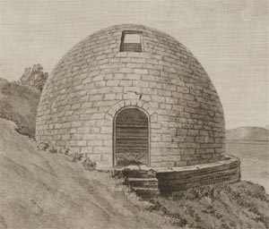
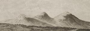
Most of the plates are therefore large scale plans of particular sites. He also included plans of camps taken from the major military historians: Polybius of the 2nd century BC, and Hyginus Gromaticus, probably of the 2nd century AD. These plans were complemented by several views, including one of Arthur's O'on, presumed to have been a Roman victory monument (destroyed in 1743), and sketches of the inscribed stones, recently discovered in the 1760s at Auchendavy and Castlecary.
Chronology of surveying of particular sites
- 1752 - Castle O'er (XXVI), Chew Green (Plate XXII), and Netherby (XLVI)
- 1752-3 - Burnswark (XVI and XXIV), and Wood Castle (VIII)
- 1753 - Castledykes (XXVII) and Lyne (XXVIII)
- 1755 - Antonine Wall (XXXV), Ardoch (X, XXX, and XXXI), Battledykes (XIII), Camelon (XXIX), Dalginross (XI), Duntocher Bridge (XXXVII), Inchtuthil (XVIII), Keithick, Kirkbuddo and Lintrose (XIV), Strageath (XXXII), the White and Brown Catherthuns (XLVIII)
- 1764 - Cleghorn (IX)
- 1769 - Castlecary (XXXIX), Channelkirk (VI), Kreiginthorp and Reycross (XVII), Tassies Holm (VIII), Torwood Moor (VII)
- 1771 - Auchendavy (XXXVIII), the Eildons (XXI), Grassy Walls and Bertha (XII)
Text
Roy's text, completed by the summer of 1773, is divided into five main sections or 'books':
- A history of the Romans in Britain
- A history of the Roman militia and their encampments
- A descriptive topography of Scotland
- A description of the ancient geography of Scotland
- A description of the Antonine Wall
The text of the Military Antiquities... 'is but seldom referred to [having] little to teach us, save a respect for the author's modesty and fairness of mind, and for the scientific spirit in which he confronts the problems that he sets himself' (MacDonald, 1917, p.161). Nevertheless, although later archaeologists have been able to take Roy's initial work much further, and correct his interpretation of some sites, the text still allows a fuller understanding on the background and form of the many Roman camps in Scotland.
Manuscript copies and publication

The most complete manuscript copy of the Military Antiquities... was presented to King George III, and survives today in the British Library (King's MS. 248). There are also several beautifully executed plans by Roy in the British Library K.Top. collections. Although Roy in his will was clear that the King's copy should be preferred for engraving / publication, perhaps through an oversight, in the event, the poorer copy he bequeathed to the Society of Antiquaries was mainly used. Thomas Camberlain, a draughtsman at the Board of Ordnance Drawing Room in the Tower of London, was employed to copy the plans, and they were engraved by James Basire. (MacDonald (1917) contains a plate-by-plate comparison). It is estimated that about 750 copies of the Military Antiquities... were printed in 1793, with each of the 513 members of the Society of Antiquaries (listed at the end of the volume) receiving a copy.
Bibliography
Breeze, David J, Roman Scotland: frontier country. (London: B.T. Batsford; Historic Scotland, 1996)
Macdonald, George, 'General William Roy and his 'Military Antiquities of the Romans in North Britain', Archaeologia, LXVIII (1917), 161-228.
Maxwell, Gordon S, The Romans in Scotland. (Edinburgh: James Thin, 1989)
O'Donoghue, Yolande, William Roy 1726-1790: Pioneer of the Ordnance Survey. (London: British Library, 1977)
Further information:
- Introduction
- Roman conquests of Scotland and William Roy
- Plans, chronology of surveying, and publication
