Admiralty Charts of Scotland, 1795-1904
| Name: | Great Britain. Hydrographic Office. Simpson, C.H., Captain |
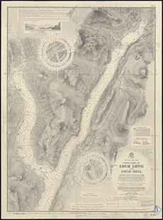
| Title: | Upper part of Loch Long and Loch Goil |
| Imprint: | [London: Hydrographic Office], 1908. Revised to 1928. |
| Pagination: | 1 map; 700 x 515 mm. |
| Shelfmark: | MS.5855, No.61 |
| Notes: | Admiralty Chart 3739. This map is from our Stevenson civil engineering plans collection. |
| Zoom Into Map: | Click on the map to view in greater detail. |