Admiralty Charts of Scotland, 1795-1904
| Name: | Great Britain. Hydrographic Office.< br/>Smith & Jeffrey |
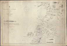
| Title: | Lochs Laxford and Inchard with Scourie Bay. Surveyed by Smith and Jeffrey, 1846. Revisions to 1865. |
| Pagination: | 1 map :col. ; 69 x 100 cm |
| Shelfmark: | Acc.10225/271 |
| Notes: | We are very grateful to Sutherland Estates for permission to display this map on our website. Sutherland Estate mapping home page. |
| Zoom Into Map: | Click on the map to view in greater detail. |