Estate Maps, 1750s-1900s
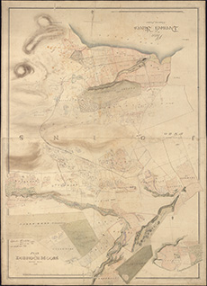
| Title: | Plan of Dornoch Moors North Part and South Part, 1820, showing allotments and cultivated land |
| Pagination: | 1 map ; 99 x 90 cm |
| Shelfmark: | Acc.10225/39 |
| Notes: | We are very grateful to Sutherland Estates for permission to display this map on our website. Sutherland Estate mapping home page. |
| Zoom Into Map: | Click on the map to view in greater detail. |