County maps, 1580s-1950s
| Name: | Ordnance Survey |
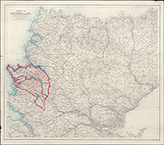
| Title: | Annotated OS map of the County of Sutherland showing land proposed to be sold to Andrew Carnegie, 1895-9 |
| Imprint: | 1895-9 |
| Pagination: | 1 map: col.; 79 x 89 cm |
| Shelfmark: | Acc.10225/293(iii) |
| Notes: | We are very grateful to Sutherland Estates for permission to display this map on our website. Sutherland Estate mapping home page. |
| Zoom Into Map: | Click on the map to view in greater detail. |