Estate Maps, 1750s-1900s
| Name: | Beattie, James J. |
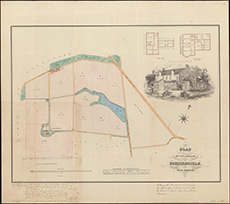
| Title: | Plan of the lands of Burnieboozle near Aberdeen / (by James J. Beattie, land surveyor. Maclure & Macdonald Litho.). |
| Imprint: | [Aberdeen, 1848] |
| Pagination: | 1 map ; 445 x 593 mm. |
| Shelfmark: | EMS.s.540 |
| Zoom Into Map: | Click on the map to view in greater detail. |