Estate Maps, 1750s-1900s

| Name: | Turnbull, James (fl.ca. 1754-84) |
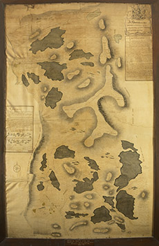
| Title: | A Survey of the Hill of Weaves and other barren ground contiguous, being part of the Barony of Castle Leod, drawn by James Turnbull, 1762 |
| Imprint: | Surveyed: 1762 |
| Pagination: | 1 ms. map : hand col.; 205 x 132 cm. |
| Shelfmark: | NOSAS CL.4 |
| Notes: | Scale: 1:5498. Peter May, an Aberdeenshire surveyor, was appointed by the Commissioners of the Forfeited Estates to survey the lands of the Cromartie Estate, which he undertook in 1756. This is likely to be his survey, although perhaps drawn by James Turnbull, a draughtsman that worked with him, six years later. Courtesy of the North of Scotland Archaeological Society. |
| Zoom Into Map: | Click on the map to view in greater detail. |