Estate Maps, 1750s-1900s
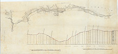

| Title: | [Road Morar to Mallaig] |
| Imprint: | 19th century |
| Pagination: | 1 map: col.; 42 x 90 cm. |
| Shelfmark: | Lovat338 |
| Notes: | 1:3960. (40 chains = 8" ). An undated, unsigned map showing the road from Morar to Mallaig. Note South is on the right.. Courtesy of Lovat Highland Estates and the North of Scotland Archaeological Society. View Lovat Highland Estates mapping |
| Zoom Into Map: | Click on the map to view in greater detail. |