Estate Maps, 1750s-1900s

| Name: | Gordon, David, 1820-1893 |
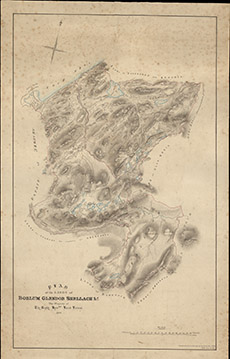
| Title: | Plan of the Lands of Borlum, Glendoe, Shellach, etc the Property of the Right Hon Lord Lovat, 1859 |
| Imprint: | 1859 |
| Pagination: | 1 manuscript map: col.; 64 x 40 cm. |
| Shelfmark: | Lovat326 |
| Notes: | 1:31680. (40 chains = 1" ). Handwritten on map: Reduced from a survey by David Gordon 1859, 09 March 1864. Courtesy of Lovat Highland Estates and the North of Scotland Archaeological Society. View Lovat Highland Estates mapping |
| Zoom Into Map: | Click on the map to view in greater detail. |