Estate Maps, 1750s-1900s

| Name: | Ordnance Survey |
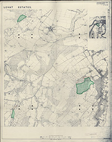
| Title: | Lovat Estates |
| Imprint: | 1962 |
| Pagination: | 1 map: col.; 87 x 69 cm. |
| Shelfmark: | Lovat293 |
| Notes: | On the background of a standard OS sheet (Inverness-shire LXVIII) a shaded area of green based on Cabrich. Printed on bottom R corner:THIS IS THE MAP REFERRED TO IN MY LETTER OF 16th January 1962 (then a signature) Scale 1:10560. (6" = 1 mile ). Courtesy of Lovat Highland Estates and the North of Scotland Archaeological Society. View Lovat Highland Estates mapping |
| Zoom Into Map: | Click on the map to view in greater detail. |