Estate Maps, 1750s-1900s

| Name: | Abernethy, James |
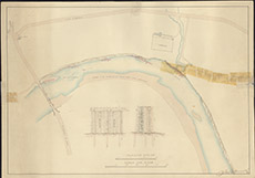
| Title: | [River Piling and Embanking at Teawig] |
| Imprint: | 1830s ? |
| Pagination: | 1 map: col.; 45 x 64 cm. |
| Shelfmark: | Lovat275 |
| Notes: | Shows Teawig Farm, near Beauly Bridge, with proposed embankment and weirs Scale 1:1200. (500' = 5" ). Courtesy of Lovat Highland Estates and the North of Scotland Archaeological Society. View Lovat Highland Estates mapping |
| Zoom Into Map: | Click on the map to view in greater detail. |