Estate Maps, 1750s-1900s

| Name: | Ordnance Survey |
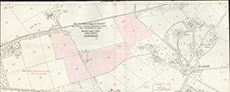
| Title: | Board of Agriculture of Scotland: Plan Showing Proposed Alternative Scemes for Enlargements from Wester Lovat Farm, Lovat Estate, Inverness-shire |
| Imprint: | 1913 |
| Pagination: | 1 map: col.; 38 x 94 cm. |
| Shelfmark: | Lovat255 |
| Notes: | Part of a standard 1903 25" map, showing fields in pink representing proposed enlargements Scale 1:2534. (25" = 1 mile ). Courtesy of Lovat Highland Estates and the North of Scotland Archaeological Society. View Lovat Highland Estates mapping |
| Zoom Into Map: | Click on the map to view in greater detail. |