Estate Maps, 1750s-1900s

| Name: | Mitchell, Joseph (1803-1883) |
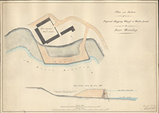
| Title: | Plan and Section of a Proposed Shipping Wharf at Wester Lovat on the River Beauley |
| Imprint: | 1839 |
| Pagination: | 1 map: col.; 52 x 73 cm. |
| Shelfmark: | Lovat253 |
| Notes: | A map showing in detail the wharf proposed on the northern bank of the Beauly. A similar "shipping wharf" map, Lovat 253, covers a larger geographical area. Scale 1:369. (200' = 6.5" ). Courtesy of Lovat Highland Estates and the North of Scotland Archaeological Society. View Lovat Highland Estates mapping |
| Zoom Into Map: | Click on the map to view in greater detail. |