Estate Maps, 1750s-1900s

| Name: | Gordon, David, 1820-1893 |
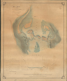
| Title: | Plan and Section of the site of a Proposed Bridge at the Lower Kilmorack Falls |
| Imprint: | 1848 |
| Pagination: | 1 map: col.; 73 x 60 cm. |
| Shelfmark: | Lovat245 |
| Notes: | Line of bridge indicated by A-B on the map Scale 1:640. (400' = 7.5" ). Courtesy of Lovat Highland Estates and the North of Scotland Archaeological Society. View Lovat Highland Estates mapping |
| Zoom Into Map: | Click on the map to view in greater detail. |