Estate Maps, 1750s-1900s

| Name: | Ordnance Survey |
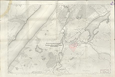
| Title: | Board of Agriculture for Scotland Garthbeg Small Holdings Scheme Proposed Enlarggement. |
| Imprint: | 1913 |
| Pagination: | 1 map: col.; 68 x 102 cm. |
| Shelfmark: | Lovat217 |
| Notes: | Overwritten on a standard 2nd Edn 6"=1mile OS Map, is a drawn and coloured area just east of Whitebridge in Stratherrick. Stamped: Board of Agriculture for Scotland, 122 George Street, Edinburgh Wallace Coles Chief Surveyor 24/4/13 Scale 1:10560. (6" = 1 mile ). Courtesy of Lovat Highland Estates and the North of Scotland Archaeological Society. View Lovat Highland Estates mapping |
| Zoom Into Map: | Click on the map to view in greater detail. |