Estate Maps, 1750s-1900s
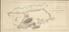

| Title: | Sketch of the Hill Ground of Crochiel and Inchullie, 1860. |
| Imprint: | 1860 |
| Pagination: | 1 map: col.; 26 x 56 cm. |
| Shelfmark: | Lovat178 |
| Notes: | Also shows the march with Chisholm Scale 1:15840. (1 mile = 4" ). Courtesy of Lovat Highland Estates and the North of Scotland Archaeological Society. View Lovat Highland Estates mapping |
| Zoom Into Map: | Click on the map to view in greater detail. |