Estate Maps, 1750s-1900s
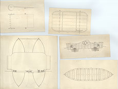

| Title: | [Proposed Chain Boat on the Beauly] |
| Imprint: | 1850 05 |
| Pagination: | 5 maps in one image; 81 x 106 cm |
| Shelfmark: | Lovat150 |
| Notes: | Five separate plans on one sheet, and an accompanying letter of explanation, rolled up inside each other. Relating to a proposed floating boat bridge or ferry across the Beauly River. Dated, not signed. Scale 1:24. (1/2" = 1' ). Courtesy of Lovat Highland Estates and the North of Scotland Archaeological Society. View Lovat Highland Estates mapping |
| Zoom Into Map: | Click on the map to view in greater detail. |