Estate Maps, 1750s-1900s
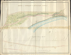

| Title: | Sketch of Approach to Beaufort Castle |
| Imprint: | 1840 |
| Pagination: | 1 manuscript map: col.; 65 x 83 cm. |
| Shelfmark: | Lovat105 |
| Notes: | Section along the Beauly Road from Junction of Belladrum Road, showing the proposed cutting Scale 1:1333. (700' = 6.3" ). Courtesy of Lovat Highland Estates and the North of Scotland Archaeological Society. View Lovat Highland Estates mapping |
| Zoom Into Map: | Click on the map to view in greater detail. |