Estate Maps, 1750s-1900s

| Name: | Ordnance Survey |
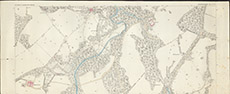
| Title: | Kiltarlity & Convinth Parish Inverness Sheet X 11. |
| Imprint: | 1872 |
| Pagination: | 1 map: col.; 45 x 110 cm. |
| Shelfmark: | Lovat095 |
| Notes: | Part of a standard 25" 1st edition OS map, centred on the area S of Beaufort Castle Scale 1:2534. (25" = 1 mile ). Courtesy of Lovat Highland Estates and the North of Scotland Archaeological Society. View Lovat Highland Estates mapping |
| Zoom Into Map: | Click on the map to view in greater detail. |