Town Plans / Views, 1580s-1940s
| Name: | Stevenson, Robert, 1772-1850 |
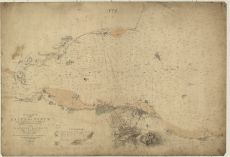
| Title: | Chart of the Firth of Forth from Queensferry to Inchkeith, showing the relative position of the proposed harbour at Granton ... Edinburgh, 1834 |
| Pagination: | 1 map : col. ; 68 x 99 cm |
| Shelfmark: | Acc.10706, No.293 |
| Zoom Into Map: | Click on the map to view in greater detail. |
| Notes: | This map is from our Stevenson civil engineering plans collection. |