Your subject search for Road returned 78 records.
Ordered chronologically (undated items first).
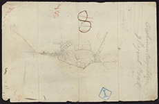
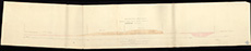
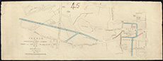
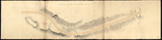
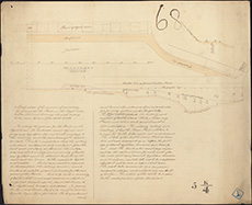
| Description: | Edinburgh: Canonmills. Section of new road from Dundas Street | |
| Place: | Edinburgh, Canonmills | |
| County: | Edinburgh | |
| Subject: | Road | |
| Inventory: | Drawing | |
| Colour: | Colour | |
| Media: | Graphite; Hand coloured; Ink | |
| Object: | Folded | |
| Physical: | Paper | |
| Size: | 530 mm x 2400 mm | |
| Shelfmark: | MS.5848, 25 | |
| Show location on map ? | ||
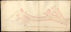
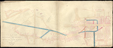
| Description: | Edinburgh, Leith. Leith Street to Foot of Leith Walk | |
| Place: | Leith | |
| County: | Edinburgh | |
| Subject: | Road | |
| Inventory: | Drawing | |
| Colour: | Colour | |
| Media: | Hand coloured; Ink | |
| Object: | Folded | |
| Physical: | Paper | |
| Size: | 490 mm x 2800 mm | |
| Shelfmark: | MS.5848, 94 | |
| Show location on map ? | ||
| Description: | Edinburgh, Regent Road. Section | |
| Place: | Edinburgh, Regent Road | |
| County: | Edinburgh | |
| Subject: | Road | |
| Inventory: | Drawing | |
| Colour: | Colour | |
| Media: | Hand coloured; Ink | |
| Object: | Flat | |
| Physical: | Paper | |
| Size: | 572 mm x 845 mm | |
| Shelfmark: | MS.5849, 58 | |
| Show location on map ? | ||
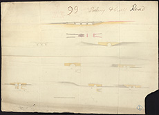
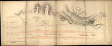
| Description: | Edinburgh, Regent Road. Section from Jock's Lodge to Baron Norton's Gate | |
| Place: | Edinburgh, Regent Road | |
| County: | Edinburgh | |
| Subject: | Road | |
| Inventory: | Drawing | |
| Colour: | B&W | |
| Media: | Graphite; Ink | |
| Object: | Folded | |
| Physical: | Paper | |
| Size: | 775 mm x 1980 mm | |
| Shelfmark: | MS.5849, 59 | |
| Show location on map ? | ||
| Description: | Edinburgh, Regent Road. Sections | |
| Place: | Edinburgh, Regent Road | |
| County: | Edinburgh | |
| Subject: | Road | |
| Inventory: | Series of 5 drawings | |
| Colour: | Colour | |
| Media: | Hand coloured; Ink | |
| Object: | Folded | |
| Physical: | Paper | |
| Size: | 530 mm x 2620 mm | |
| Shelfmark: | MS.5849, 60 | |
| Show location on map ? | ||
| Description: | Edinburgh, Regent Road. Copy of Parliamentary Plan | |
| Place: | Edinburgh, Regent Road | |
| County: | Edinburgh | |
| Subject: | Road | |
| Inventory: | Drawing | |
| Colour: | B&W | |
| Media: | Graphite; Ink | |
| Object: | Flat | |
| Physical: | Paper | |
| Size: | 320 mm x 205 mm | |
| Shelfmark: | MS.5849, 65 | |
| Show location on map ? | ||
 | ||
| Zoom Into Map: | Click on the map to view in greater detail. | |
| Description: | Edinburgh, Regent Road. East End of Princes Street showing Regent Bridge | |
| Place: | Edinburgh, Regent Road | |
| County: | Edinburgh | |
| Subject: | Road | |
| Inventory: | Drawing | |
| Colour: | Colour | |
| Media: | Hand coloured; Ink | |
| Object: | Folded | |
| Physical: | Paper | |
| Size: | 580 mm x 1292 mm | |
| Shelfmark: | MS.5849, 66 | |
| Show location on map ? | ||
 | ||
| Zoom Into Map: | Click on the map to view in greater detail. | |
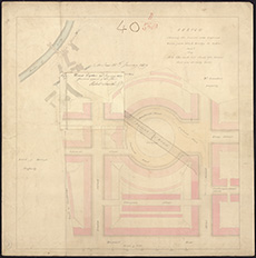
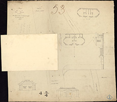
| Description: | Edinburgh, Regent Road. Sketches of proposed new buildings | |
| Place: | Edinburgh, Regent Road | |
| County: | Edinburgh | |
| Subject: | Road | |
| Inventory: | Series of 2 drawings | |
| Colour: | Colour | |
| Media: | Hand coloured; Ink | |
| Object: | Flat | |
| Physical: | Paper | |
| Size: | 330 mm x 561 mm | |
| Shelfmark: | MS.5849, 67 | |
| Show location on map ? | ||
 | ||
| Zoom Into Map: | Click on the map to view in greater detail. | |
| Description: | Edinburgh, Regent Road. Section of Windsor Street and Leopold | |
| Place: | Edinburgh, Regent Road | |
| County: | Edinburgh | |
| Subject: | Road | |
| Inventory: | Drawing | |
| Colour: | Colour | |
| Media: | Hand coloured; Ink | |
| Object: | Flat | |
| Physical: | Paper | |
| Size: | 535 mm x 635 mm | |
| Shelfmark: | MS.5849, 69 | |
| Show location on map ? | ||
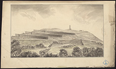
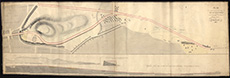
| Description: | Edinburgh: Calton Hill. Sections | |
| Place: | Edinburgh, Calton Hill | |
| County: | Edinburgh | |
| Subject: | Road | |
| Inventory: | Drawing | |
| Colour: | B&W | |
| Media: | Graphite; Ink | |
| Object: | Flat | |
| Physical: | Transparent paper/Linen/Cloth | |
| Size: | 705 mm x 1020 mm | |
| Shelfmark: | MS.5848, 14 | |
| Show location on map ? | ||
| Description: | Edinburgh: Calton Hill. Sketch plan and section of road | |
| Place: | Edinburgh, Calton Hill | |
| County: | Edinburgh | |
| Subject: | Road | |
| Inventory: | Drawing | |
| Colour: | Colour | |
| Media: | Hand coloured; Ink | |
| Object: | Folded | |
| Physical: | Paper | |
| Size: | 580 mm x 1170 mm | |
| Shelfmark: | MS.5848, 15 | |
| Show location on map ? | ||
| Description: | Edinburgh, London Road. Sections through lands of Hillside | |
| Place: | Edinburgh, London Road | |
| County: | Edinburgh | |
| Subject: | Road | |
| Inventory: | Drawing | |
| Colour: | Colour | |
| Media: | Hand coloured; Ink | |
| Object: | Flat | |
| Physical: | Paper | |
| Size: | 564 mm x 1032 mm | |
| Shelfmark: | MS.5849, 9 | |
| Show location on map ? | ||
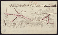
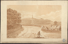
| Description: | Edinburgh, Princes Street. Sketch of East End with proposed alterations | |
| Place: | Edinburgh, Princes Street | |
| County: | Edinburgh | |
| Subject: | Road | |
| Inventory: | Drawing | |
| Colour: | Colour | |
| Media: | Hand coloured; Ink | |
| Object: | Flat | |
| Physical: | Paper | |
| Size: | 325 mm x 535 mm | |
| Shelfmark: | MS.5849, 50 | |
| Show location on map ? | ||
 | ||
| Zoom Into Map: | Click on the map to view in greater detail. | |
| Description: | Kingston. Longitudinal section for Branch Tramroad | |
| Place: | Kingston | |
| County: | Elgin | |
| Subject: | Road | |
| Inventory: | Drawing | |
| Colour: | Colour | |
| Media: | Graphite; Hand coloured; Ink | |
| Object: | Folded | |
| Physical: | Paper | |
| Size: | 330 mm x 1835 mm | |
| Shelfmark: | MS.5854, 15 | |
| Show location on map ? | ||
 | ||
| Zoom Into Map: | Click on the map to view in greater detail. | |
| Name: | Stevenson (unspecified) | |
| Description: | Lerwick. Road from Lerwick to the Gill of Frackafield | |
| Place: | Lerwick | |
| County: | Zetland | |
| Subject: | Road | |
| Inventory: | Print by Forrester and Ruthven | |
| Colour: | Colour | |
| Media: | Hand coloured; Printed | |
| Object: | Flat | |
| Physical: | Paper | |
| Size: | 492 mm x 610 mm | |
| Shelfmark: | MS.5855, 15 | |
| Show location on map ? | ||
| Name: | Stevenson, Robert, 1772-1850 | |
| Description: | Linlithgow. Sketch survey of Turnpike road from Linlithgow to Falkirk at Castle Bridge | |
| Place: | Linlithgow | |
| County: | West Lothian | |
| Subject: | Road | |
| Inventory: | Drawing | |
| Colour: | Colour | |
| Media: | Hand coloured; Ink | |
| Object: | Folded | |
| Physical: | Paper | |
| Size: | 500 mm x 1220 mm | |
| Shelfmark: | MS.5855, 48 | |
| Show location on map ? | ||
| Description: | Stirling. Sections of Stirling and Crieff road | |
| Place: | Stirling | |
| County: | Stirling | |
| Subject: | Road | |
| Inventory: | Drawing | |
| Colour: | Colour | |
| Media: | None | |
| Object: | Flat | |
| Physical: | Card | |
| Size: | 535 x 755 mm | |
| Shelfmark: | MS.5862, 114 | |
| Show location on map ? | ||
 | ||
| Zoom Into Map: | Click on the map to view in greater detail. | |
| Name: | Stevenson, Robert, 1772-1850 | |
| Description: | Roads and Bridges - Edinburgh. Sketch showing the western line of approach to the City of Edinburgh proposed by Mr Stevenson, n.d. | |
| Place: | Edinburgh, Calton Hill | |
| County: | Edinburgh | |
| Subject: | Road | |
| Colour: | Colour | |
| Media: | None | |
| Object: | Flat | |
| Physical: | Paper | |
| Size: | 145 x 240 mm | |
| Shelfmark: | Acc.10706, 462 | |
| Show location on map ? | ||
 | ||
| Zoom Into Map: | Click on the map to view in greater detail. | |
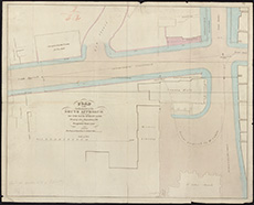
| Description: | Roads and Bridges - Edinburgh. Plan of the northern part of the south approach by the Bank Street Line, showing also the position of the proposed East Line, n.d. | |
| Place: | Edinburgh, Bank Street | |
| County: | Edinburgh | |
| Subject: | Road | |
| Colour: | Colour | |
| Media: | None | |
| Object: | Flat | |
| Physical: | Paper | |
| Size: | 450 x 560 mm | |
| Shelfmark: | Acc.10706, 463 | |
| Show location on map ? | ||
 | ||
| Zoom Into Map: | Click on the map to view in greater detail. | |
| Description: | Edinburgh. Sketch showing the improvements to the Stockbridge Road. | |
| Place: | Edinburgh | |
| County: | Edinburgh | |
| Subject: | Road | |
| Colour: | Colour | |
| Media: | None | |
| Object: | Folded | |
| Physical: | Paper | |
| Size: | 260 x 12770 mm | |
| Shelfmark: | Acc.10706, 683 | |
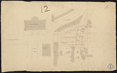
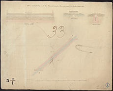
| Description: | Edinburgh, Regent Road. Sections | |
| Place: | Edinburgh, Regent Road | |
| County: | Edinburgh | |
| Subject: | Road | |
| Inventory: | Series of 5 drawings | |
| Colour: | Colour | |
| Media: | Graphite; Hand coloured; Ink | |
| Object: | Folded | |
| Physical: | Paper | |
| Size: | 540 mm x 2610 mm | |
| Shelfmark: | MS.5849, 61 | |
| Description: | Edinburgh, Regent Road. Sections | |
| Place: | Edinburgh, Regent Road | |
| County: | Edinburgh | |
| Subject: | Road | |
| Inventory: | Series of 5 drawings | |
| Colour: | Colour | |
| Media: | Graphite; Hand coloured; Ink | |
| Object: | Folded | |
| Physical: | Paper | |
| Size: | 430 mm x 4750 mm | |
| Shelfmark: | MS.5849, 62 | |
| Description: | Edinburgh, Regent Road. Sections | |
| Place: | Edinburgh, Regent Road | |
| County: | Edinburgh | |
| Subject: | Road | |
| Inventory: | Series of 5 drawings | |
| Colour: | Colour | |
| Media: | Graphite; Hand coloured; Ink | |
| Object: | Folded | |
| Physical: | Paper | |
| Size: | 573 mm x 1355 mm | |
| Shelfmark: | MS.5849, 63 | |
| Description: | Edinburgh, Regent Road. Sections | |
| Place: | Edinburgh, Regent Road | |
| County: | Edinburgh | |
| Subject: | Road | |
| Inventory: | Series of 5 drawings | |
| Colour: | Colour | |
| Media: | Graphite; Hand coloured; Ink | |
| Object: | Folded | |
| Physical: | Paper | |
| Size: | 325 mm x 1050 mm | |
| Shelfmark: | MS.5849, 64 | |
| Description: | Edinburgh, Regent Road. Sketches of proposed new buildings | |
| Place: | Edinburgh, Regent Road | |
| County: | Edinburgh | |
| Subject: | Road | |
| Inventory: | Series of 2 drawings | |
| Colour: | Colour | |
| Media: | Hand coloured; Ink | |
| Object: | Flat | |
| Physical: | Paper | |
| Size: | 350 mm x 535 mm | |
| Shelfmark: | MS.5849, 68 | |
 | ||
| Zoom Into Map: | Click on the map to view in greater detail. | |
| Description: | Roads and Bridges - Edinburgh. Reduced lithograph copy of 466. | |
| Place: | Edinburgh, Grassmarket | |
| County: | Edinburgh | |
| Subject: | Road | |
| Colour: | Colour | |
| Media: | None | |
| Object: | Flat | |
| Physical: | Paper | |
| Size: | 275 x 750 mm | |
| Shelfmark: | Acc.10706, 467 | |
| Show location on map ? | ||
 | ||
| Zoom Into Map: | Click on the map to view in greater detail. | |
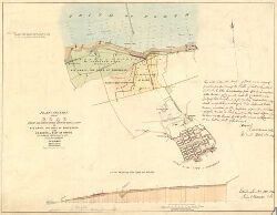
| Description: | Roads and Bridges - Edinburgh. MS plan for a new road or street from the Muscleburgh road, at or near Jocks Lodge to Princes Street, Edinburgh. [Regent Terrace] s.l.s.d. | |
| Place: | Edinburgh, Princes Street | |
| County: | Edinburgh | |
| Subject: | Road | |
| Colour: | Colour | |
| Media: | Linen/Cloth | |
| Object: | Folded | |
| Physical: | Paper | |
| Size: | 750 x 2300 mm | |
| Shelfmark: | Acc.10706, 470 | |
| Show location on map ? | ||
 | ||
| Zoom Into Map: | Click on the map to view in greater detail. | |
| Description: | Marykirk. Section of road to lead from Marykirk Bridge to Montrose and Marykirk roads | |
| Year: | 1812 | |
| Place: | Marykirk | |
| County: | Forfar ; Kincardine | |
| Subject: | Road | |
| Inventory: | Drawing | |
| Colour: | Colour | |
| Media: | Graphite; Hand coloured; Ink | |
| Object: | Folded | |
| Physical: | Paper | |
| Size: | 2675 mm x 635 mm | |
| Shelfmark: | MS.5856, 19 | |
| Show location on map ? | ||
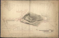
| Name: | Stevenson, Robert, 1772-1850 | |
| Description: | Roads and Bridges - Edinburgh. Survey of the lands of Calton Hill and design for a new approach to the City of Edinburgh...signed Robert Stevenson, 1814. | |
| Year: | 1814 | |
| Place: | Edinburgh, Calton Hill | |
| County: | Edinburgh | |
| Subject: | Road | |
| Colour: | Colour | |
| Media: | Linen/Cloth | |
| Object: | Folded | |
| Physical: | Paper | |
| Size: | 755 x 1280 mm | |
| Shelfmark: | Acc.10706, 464 | |
| Show location on map ? | ||
| Name: | Stevenson, Robert, 1772-1850 | |
| Description: | Roads and Bridges - Edinburgh. Plan of the lands of Calton Hill and design for a new approach to the City of Edinburgh by a bridge over Calton Street. Robert Stevenson, 1814. | |
| Year: | 1814 | |
| Place: | Edinburgh, Calton Hill | |
| County: | Edinburgh | |
| Subject: | Road | |
| Colour: | Colour | |
| Media: | Linen/Cloth | |
| Object: | Folded | |
| Physical: | Paper | |
| Size: | 650 x 990 mm | |
| Shelfmark: | Acc.10706, 465 | |
| Show location on map ? | ||
 | ||
| Zoom Into Map: | Click on the map to view in greater detail. | |
| Name: | Stevenson, Robert, 1772-1850 | |
| Description: | Lasswade. Survey of village with proposed new road | |
| Year: | 1815 | |
| Place: | Lasswade | |
| County: | Edinburgh | |
| Subject: | Road | |
| Inventory: | Drawing | |
| Colour: | Colour | |
| Media: | Hand coloured; Ink | |
| Object: | Flat | |
| Physical: | Paper/Linen/Cloth | |
| Size: | 850 mm x 1300 mm | |
| Shelfmark: | MS.5855, 5 | |
| Show location on map ? | ||
| Description: | Edinburgh: Calton Hill. Sketch, plan and section of road | |
| Year: | 1815 | |
| Place: | Edinburgh, Calton Hill | |
| County: | Edinburgh | |
| Subject: | Road | |
| Inventory: | Drawing | |
| Colour: | Colour | |
| Media: | Graphite; Hand coloured; Ink | |
| Object: | Folded | |
| Physical: | Paper | |
| Size: | 534 mm x 2175 mm | |
| Shelfmark: | MS.5848, 8 | |
| Show location on map ? | ||
 | ||
| Zoom Into Map: | Click on the map to view in greater detail. | |
| Description: | Edinburgh: Calton Hill. Section of road | |
| Year: | 1815 | |
| Place: | Edinburgh, Calton Hill | |
| County: | Edinburgh | |
| Subject: | Road | |
| Inventory: | Drawing | |
| Colour: | Colour | |
| Media: | Graphite; Hand coloured; Ink | |
| Object: | Folded | |
| Physical: | Paper | |
| Size: | 530 mm x 2090 mm | |
| Shelfmark: | MS.5848, 9 | |
| Show location on map ? | ||
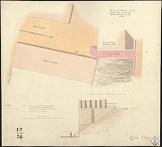
| Description: | Regent Road. Retaining Wall, Regent Road, Edinburgh (Trotter's Workshop & yard.) Watermark: W. Spear 1815 | |
| Year: | 1815 | |
| Place: | Edinburgh, Regent Road | |
| County: | Edinburgh | |
| Subject: | Road | |
| Shelfmark: | MS.5896, 1 | |
| Description: | Lasswade. Proposed new road | |
| Year: | 1816 | |
| Place: | Lasswade | |
| County: | Edinburgh | |
| Subject: | Road | |
| Inventory: | Series of 2 drawings | |
| Colour: | Colour | |
| Media: | Hand coloured; Ink | |
| Object: | Folded | |
| Physical: | Paper | |
| Size: | 530 mm x 1560 mm | |
| Shelfmark: | MS.5855, 6 | |
| Show location on map ? | ||
| Description: | Lasswade. Proposed new road | |
| Year: | 1816 | |
| Place: | Lasswade | |
| County: | Edinburgh | |
| Subject: | Road | |
| Inventory: | Series of 2 drawings | |
| Colour: | Colour | |
| Media: | Hand coloured; Ink | |
| Object: | Folded | |
| Physical: | Paper | |
| Size: | 330 mm x 1510 mm | |
| Shelfmark: | MS.5855, 7 | |
| Show location on map ? | ||
| Name: | Richardson, Thomas | |
| Description: | Glasgow. Copy of part of play of roads in Barony Parish | |
| Year: | 1817 | |
| Place: | Glasgow | |
| County: | Lanark | |
| Subject: | Road | |
| Inventory: | ||
| Colour: | Colour | |
| Media: | Hand coloured; Printed | |
| Object: | Flat | |
| Physical: | Paper | |
| Size: | 670 mm x 740 mm | |
| Shelfmark: | MS.5851, 11 | |
| Show location on map ? | ||
| Description: | Edinburgh, London Road. Sections through lands of Hillside | |
| Year: | 1817 | |
| Place: | Edinburgh, London Road | |
| County: | Edinburgh | |
| Subject: | Road | |
| Inventory: | Drawing | |
| Colour: | Colour | |
| Media: | Hand coloured; Ink | |
| Object: | Flat | |
| Physical: | Paper | |
| Size: | 655 mm x 1040 mm | |
| Shelfmark: | MS.5849, 1 | |
| Show location on map ? | ||
| Name: | Stevenson, Robert, 1772-1850 | |
| Description: | Roads and Bridges - Edinburgh. Plan of Princes Street and Regent Street signed Robert Stevenson, 1817. | |
| Year: | 1817 | |
| Place: | Edinburgh, Princes Street | |
| County: | Edinburgh | |
| Subject: | Road | |
| Colour: | Colour | |
| Media: | None | |
| Object: | Folded | |
| Physical: | Paper | |
| Size: | 285 x 3200 mm | |
| Shelfmark: | Acc.10706, 469 | |
| Show location on map ? | ||
 | ||
| Zoom Into Map: | Click on the map to view in greater detail. | |
| Description: | Roads and Bridges - Glasgow. Lithographed copy of part of map of the roads and tollbars in the neighbourhood of Glasgow. David Smith, 1818. | |
| Year: | 1818 | |
| Place: | Glasgow | |
| County: | Lanark | |
| Subject: | Road | |
| Colour: | Colour | |
| Media: | None | |
| Object: | Flat | |
| Physical: | Paper | |
| Size: | 670 x 1010 mm | |
| Shelfmark: | Acc.10706, 471 | |
| Show location on map ? | ||
| Description: | Edinburgh. Sketch showing the present and proposed roads from Stockbridge to Edinburgh, 1819 | |
| Year: | 1819 | |
| Place: | Edinburgh | |
| County: | Edinburgh | |
| Subject: | Road | |
| Colour: | Colour | |
| Media: | None | |
| Object: | Flat | |
| Physical: | Card | |
| Size: | 490 x 485 mm | |
| Shelfmark: | Acc.10706, 682 | |
 | ||
| Zoom Into Map: | Click on the map to view in greater detail. | |
| Name: | Stevenson, Robert, 1772-1850 | |
| Description: | Edinburgh: Calton Hill. Sketch showing proposed feuing of lands of Heriot's Hospital | |
| Year: | 1819 | |
| Place: | Edinburgh, Calton Hill | |
| County: | Edinburgh | |
| Subject: | Road | |
| Inventory: | Drawing | |
| Colour: | Colour | |
| Media: | Hand coloured; Ink | |
| Object: | Flat | |
| Physical: | Paper | |
| Size: | 576 mm x 845 mm | |
| Shelfmark: | MS.5848, 10 | |
| Show location on map ? | ||
| Name: | Kemp, William | |
| Description: | Denny. Improvements on road from Loanhead to Denny | |
| Year: | 1819 | |
| Place: | Denny | |
| County: | Stirling | |
| Subject: | Road | |
| Inventory: | Drawing | |
| Colour: | Colour | |
| Media: | Hand coloured; Ink | |
| Object: | Folded | |
| Physical: | Paper | |
| Size: | 515 mm x 2202 mm | |
| Shelfmark: | MS.5847, 5 | |
| Show location on map ? | ||
| Name: | M.S. | |
| Description: | Edinburgh, Regent Road. Section of Tunnel under new road by Jock's Lodge | |
| Year: | 1819 | |
| Place: | Edinburgh, Regent Road | |
| County: | Edinburgh | |
| Subject: | Road | |
| Inventory: | Series of 4 drawings | |
| Colour: | Colour | |
| Media: | Graphite; Hand coloured; Ink | |
| Object: | Flat | |
| Physical: | Paper | |
| Size: | 510 mm x 640 mm | |
| Shelfmark: | MS.5849, 54-57 | |
| Show location on map ? | ||
 | ||
| Zoom Into Map: | Click on the map to view in greater detail. | |
| Name: | Stevenson, Robert, 1772-1850 | |
| Description: | Fyne, Loch. Shore, with sections of proposed road | |
| Year: | 1819 | |
| Place: | Fyne, Loch | |
| County: | Argyll | |
| Subject: | Road | |
| Inventory: | Drawing | |
| Colour: | Colour | |
| Media: | Hand coloured; Ink | |
| Object: | Folded | |
| Physical: | Paper | |
| Size: | 450 mm x 2275 mm | |
| Shelfmark: | MS.5850, 85 | |
| Show location on map ? | ||
| Name: | Stevenson, Robert, 1772-1850 | |
| Description: | Edinburgh, Princes Street. Retaining Wall for Mr Trotter's property proposed to be erected on Princes Street | |
| Year: | 1820 | |
| Place: | Edinburgh, Princes Street | |
| County: | Edinburgh | |
| Subject: | Road | |
| Inventory: | Series of 2 drawings | |
| Colour: | Colour | |
| Media: | Graphite; Hand coloured; Ink | |
| Object: | Flat | |
| Physical: | Paper | |
| Size: | 532 mm x 650 mm | |
| Shelfmark: | MS.5849, 48-49 | |
| Show location on map ? | ||
| Description: | Edinburgh: Canonmills. Retaining Wall on Canonmills Road | |
| Year: | 1820 | |
| Place: | Edinburgh, Canonmills | |
| County: | Edinburgh | |
| Subject: | Road | |
| Inventory: | Drawing | |
| Colour: | Colour | |
| Media: | Hand coloured; Ink | |
| Object: | Flat | |
| Physical: | Paper | |
| Size: | 535 mm x 655 mm | |
| Shelfmark: | MS.5848, 20 | |
| Show location on map ? | ||
| Name: | Stevenson, Robert, 1772-1850 | |
| Description: | Kirk Kettle Ford. Survey and sections of improved lines of road at Cleugh leading ro Ford | |
| Year: | 1820 | |
| County: | Edinburgh | |
| Subject: | Road | |
| Inventory: | Drawing | |
| Colour: | Colour | |
| Media: | Graphite; Hand coloured; Ink | |
| Object: | Folded | |
| Physical: | Paper | |
| Size: | 530 mm x 1260 mm | |
| Shelfmark: | MS.5854, 47 | |
| Show location on map ? | ||
| Name: | Playfair, William Henry, 1790-1857 | |
| Description: | Edinburgh, Royal Terrace. Specification and plans for excavating ground for houses in Royal Terrace & forming road to Leith Walk | |
| Year: | 1821 | |
| Place: | Edinburgh, Royal Terrace | |
| County: | Edinburgh | |
| Subject: | Road | |
| Inventory: | Series of 3 drawings | |
| Colour: | Colour | |
| Media: | Hand coloured; Ink | |
| Object: | Flat | |
| Physical: | Paper | |
| Size: | 490 mm x 600 mm | |
| Shelfmark: | MS.5849, 71 | |
 | ||
| Zoom Into Map: | Click on the map to view in greater detail. | |
| Name: | Playfair, William Henry, 1790-1857 | |
| Description: | Edinburgh, Royal Terrace. Specification and plans for excavating ground for houses in Royal Terrace & forming road to Leith Walk | |
| Year: | 1821 | |
| Place: | Edinburgh, Royal Terrace | |
| County: | Edinburgh | |
| Subject: | Road | |
| Inventory: | Series of 3 drawings | |
| Colour: | Colour | |
| Media: | Hand coloured; Ink | |
| Object: | Flat | |
| Physical: | Paper | |
| Size: | 552 mm x 674 mm | |
| Shelfmark: | MS.5849, 72 | |
| Name: | Playfair, William Henry, 1790-1857 | |
| Description: | Edinburgh, Royal Terrace. Specification and plans for excavating ground for houses in Royal Terrace & forming road to Leith Walk | |
| Year: | 1821 | |
| Place: | Edinburgh, Royal Terrace | |
| County: | Edinburgh | |
| Subject: | Road | |
| Inventory: | Series of 3 drawings | |
| Colour: | B&W | |
| Media: | Graphite; Ink | |
| Object: | Flat | |
| Physical: | Paper | |
| Size: | 531 mm x 565 mm | |
| Shelfmark: | MS.5849, 70 | |
| Show location on map ? | ||
 | ||
| Zoom Into Map: | Click on the map to view in greater detail. | |
| Name: | Playfair, William Henry, 1790-1857 | |
| Description: | Edinburgh, Royal Terrace. Cellars and sections of houses | |
| Year: | 1821 | |
| Place: | Edinburgh, Royal Terrace | |
| County: | Edinburgh | |
| Subject: | Road | |
| Inventory: | Series of 6 drawings | |
| Colour: | Colour | |
| Media: | Hand coloured; Ink | |
| Object: | Flat | |
| Physical: | Paper | |
| Size: | 145 mm x 177 mm | |
| Shelfmark: | MS.5849, 73 | |
| Show location on map ? | ||
| Name: | Playfair, William Henry, 1790-1857 | |
| Description: | Edinburgh, London Road. Sections of drains | |
| Year: | 1821 | |
| Place: | Edinburgh, London Road | |
| County: | Edinburgh | |
| Subject: | Road | |
| Inventory: | Series of 6 drawings | |
| Colour: | Colour | |
| Media: | Hand coloured; Ink | |
| Object: | Folded | |
| Physical: | Paper | |
| Size: | 524 mm x 625 mm | |
| Shelfmark: | MS.5849, 2-7 | |
| Show location on map ? | ||
| Name: | Stevenson, Robert, 1772-1850 | |
| Description: | Linlithgow. Longitudinal cross section of main street | |
| Year: | 1822 | |
| Place: | Linlithgow | |
| County: | West Lothian | |
| Subject: | Road | |
| Inventory: | Drawing | |
| Colour: | Colour | |
| Media: | Graphite; Hand coloured; Ink | |
| Object: | Folded | |
| Physical: | Paper | |
| Size: | 785 mm x 2060 mm | |
| Shelfmark: | MS.5855, 47 | |
| Show location on map ? | ||
| Name: | Stevenson, Robert, 1772-1850 | |
| Description: | Roads and Bridges - Edinburgh. Sketch of a new proposed access from the Cross to the Grass Market. Robert Stevenson, 1824. | |
| Year: | 1824 | |
| Place: | Edinburgh, Grassmarket | |
| County: | Edinburgh | |
| Subject: | Road | |
| Colour: | Colour | |
| Media: | Linen/Cloth | |
| Object: | Flat | |
| Physical: | Paper | |
| Size: | 525 x 1300 mm | |
| Shelfmark: | Acc.10706, 466 | |
| Show location on map ? | ||
 | ||
| Zoom Into Map: | Click on the map to view in greater detail. | |
| Name: | Stevenson, Robert, 1772-1850 | |
| Description: | Stirling. Proposed alternations on road from Stirling to Crieff | |
| Year: | 1826 | |
| Place: | Stirling | |
| County: | Stirling | |
| Subject: | Road | |
| Inventory: | Series of 2 drawings | |
| Colour: | Colour | |
| Media: | Linen/Cloth | |
| Object: | Folded | |
| Physical: | Paper | |
| Size: | 725 x 1800 mm | |
| Shelfmark: | MS.5862, 109 | |
| Show location on map ? | ||
 | ||
| Zoom Into Map: | Click on the map to view in greater detail. | |
| Name: | Stevenson, Robert, 1772-1850 | |
| Description: | Stirling. Proposed alternations on road from Stirling to Crieff | |
| Year: | 1826 | |
| Place: | Stirling | |
| County: | Stirling | |
| Subject: | Road | |
| Inventory: | Series of 2 drawings | |
| Colour: | Colour | |
| Media: | None | |
| Object: | Folded | |
| Physical: | Card | |
| Size: | 920 x 1600 mm | |
| Shelfmark: | MS.5862, 110 | |
| Show location on map ? | ||
| Name: | Stevenson, Robert, 1772-1850 | |
| Description: | Denny. Surrounding lands and roads | |
| Year: | 1826 | |
| Place: | Denny | |
| County: | Stirling | |
| Subject: | Road | |
| Inventory: | Drawing | |
| Colour: | Colour | |
| Media: | Graphite; Hand coloured; Ink | |
| Object: | Folded | |
| Physical: | Paper | |
| Size: | 605 mm x 1270 mm | |
| Shelfmark: | MS.5847, 8 | |
| Show location on map ? | ||
| Name: | W.M.M. | |
| Description: | Perth. Section, showing turnpike road to Dundee and old road to Dundee | |
| Year: | 1827 | |
| Place: | Perth | |
| County: | Perth | |
| Subject: | Road | |
| Inventory: | Drawing | |
| Colour: | Colour | |
| Media: | Graphite; Hand coloured; Ink | |
| Object: | Flat | |
| Physical: | Paper | |
| Size: | 450 mm x 790 mm | |
| Shelfmark: | MS.5859, 11 | |
| Show location on map ? | ||
 | ||
| Zoom Into Map: | Click on the map to view in greater detail. | |
| Description: | Glasgow. Proposed road from Glasgow to Kilmarnock | |
| Year: | 1830 | |
| Place: | Glasgow | |
| County: | Lanark | |
| Subject: | Road | |
| Inventory: | ||
| Colour: | Colour | |
| Media: | Hand coloured; Printed | |
| Object: | Folded | |
| Physical: | Paper | |
| Size: | 330 mm x 675 mm | |
| Shelfmark: | MS.5851, 30 | |
| Show location on map ? | ||
| Description: | . Sketch map of the streets adjacent to the top of Leith Walk showing projected new streets, on paper watermarked 1830. | |
| Year: | 1830 | |
| Place: | Edinburgh | |
| County: | Edinburgh | |
| Subject: | Road | |
| Colour: | Colour | |
| Media: | None | |
| Object: | Flat | |
| Physical: | Paper | |
| Size: | 405 x 585 mm | |
| Shelfmark: | Acc.10706, 381 | |
| Show location on map ? | ||
 | ||
| Zoom Into Map: | Click on the map to view in greater detail. | |
| Name: | Stevenson, Robert, 1772-1850 | |
| Description: | Edinburgh: Howard Place. New road to Warriston | |
| Year: | 1831 | |
| Place: | Edinburgh, Howard Place | |
| County: | Edinburgh | |
| Subject: | Road | |
| Inventory: | Drawing | |
| Colour: | Colour | |
| Media: | Hand coloured; Ink | |
| Object: | Flat | |
| Physical: | Paper | |
| Size: | 664 mm x 990 mm | |
| Shelfmark: | MS.5848, 62 | |
| Show location on map ? | ||
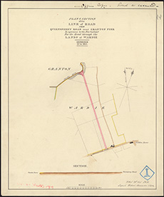
| Name: | Stevenson, Robert, 1772-1850 | |
| Description: | Edinburgh: Granton. Plan of road from Granton Pier to Leith and Queensferry Road | |
| Year: | 1835 | |
| Place: | Granton | |
| County: | Edinburgh | |
| Subject: | Road | |
| Inventory: | Series of 4 drawings | |
| Colour: | Colour | |
| Media: | Hand coloured; Printed | |
| Object: | Flat | |
| Physical: | Paper/Linen/Cloth | |
| Size: | 465 mm x 385 mm | |
| Shelfmark: | MS.5848, 48 | |
| Show location on map ? | ||
 | ||
| Zoom Into Map: | Click on the map to view in greater detail. | |
| Name: | Stevenson, Robert, 1772-1850 | |
| Description: | Edinburgh: Granton. Plan of road from Granton Pier to Leith and Queensferry Road | |
| Year: | 1835 | |
| Place: | Granton | |
| County: | Edinburgh | |
| Subject: | Road | |
| Inventory: | Series of 4 drawings | |
| Colour: | Colour | |
| Media: | Hand coloured; Printed | |
| Object: | Flat | |
| Physical: | Paper | |
| Size: | 410 mm x 345 mm | |
| Shelfmark: | MS.5848, 49 | |
| Show location on map ? | ||
 | ||
| Zoom Into Map: | Click on the map to view in greater detail. | |
| Name: | Stevenson, Robert, 1772-1850 | |
| Description: | Edinburgh: Granton. Plan of road from Granton Pier to Leith and Queensferry Road | |
| Year: | 1835 | |
| Place: | Granton | |
| County: | Edinburgh | |
| Subject: | Road | |
| Inventory: | Series of 4 drawings | |
| Colour: | Colour | |
| Media: | Hand coloured; Printed | |
| Object: | Flat | |
| Physical: | Paper | |
| Size: | 375 mm x 313 mm | |
| Shelfmark: | MS.5848, 50 | |
| Show location on map ? | ||
 | ||
| Zoom Into Map: | Click on the map to view in greater detail. | |
| Name: | Stevenson, Robert, 1772-1850 | |
| Description: | Edinburgh: Granton. Plan of road from Granton Pier to Leith and Queensferry Road | |
| Year: | 1835 | |
| Place: | Granton | |
| County: | Edinburgh | |
| Subject: | Road | |
| Inventory: | Series of 4 drawings | |
| Colour: | Colour | |
| Media: | Hand coloured; Ink | |
| Object: | Flat | |
| Physical: | Paper | |
| Size: | 525 mm x 380 mm | |
| Shelfmark: | MS.5848, 51 | |
| Show location on map ? | ||
 | ||
| Zoom Into Map: | Click on the map to view in greater detail. | |
| Name: | Stevenson, Robert, 1772-1850 ; Stevenson, Alan, 1807-1865 | |
| Description: | Edinburgh: Granton. Plan and section of road | |
| Year: | 1836 | |
| Place: | Granton | |
| County: | Edinburgh | |
| Subject: | Road | |
| Inventory: | Drawing | |
| Colour: | Colour | |
| Media: | Hand coloured; Ink | |
| Object: | Flat | |
| Physical: | Paper | |
| Size: | 564 mm x 721 mm | |
| Shelfmark: | MS.5848, 56 | |
| Show location on map ? | ||
 | ||
| Zoom Into Map: | Click on the map to view in greater detail. | |
| Name: | Stevenson, Robert, 1772-1850 | |
| Description: | Springfield. Plan of road and sections | |
| Year: | 1836 | |
| Place: | Edinburgh, Springfield | |
| County: | Edinburgh | |
| Subject: | Road | |
| Inventory: | Drawing | |
| Colour: | Colour | |
| Media: | None | |
| Object: | Flat | |
| Physical: | Card | |
| Size: | 775 x 1900 mm | |
| Shelfmark: | MS.5862, 102 | |
| Show location on map ? | ||
| Name: | Stevenson, Robert, 1772-1850 ; Stevenson, Alan, 1807-1865 | |
| Description: | Edinburgh: Granton. Sections of Granton Road | |
| Year: | 1837 | |
| Place: | Granton | |
| County: | Edinburgh | |
| Subject: | Road | |
| Inventory: | Drawing | |
| Colour: | Colour | |
| Media: | Hand coloured; Ink | |
| Object: | Flat | |
| Physical: | Paper | |
| Size: | 374 mm x 532 mm | |
| Shelfmark: | MS.5848, 57 | |
| Show location on map ? | ||
| Name: | Stevenson, Robert, 1772-1850 | |
| Description: | Edinburgh, London Road. Cross Sections | |
| Year: | 1838 | |
| Place: | Edinburgh, London Road | |
| County: | Edinburgh | |
| Subject: | Road | |
| Inventory: | Drawing | |
| Colour: | Colour | |
| Media: | Hand coloured; Ink | |
| Object: | Folded | |
| Physical: | Paper | |
| Size: | 320 mm x 1680 mm | |
| Shelfmark: | MS.5849, 8 | |
| Show location on map ? | ||
 | ||
| Zoom Into Map: | Click on the map to view in greater detail. | |
| Name: | Whyte, George | |
| Description: | Deer. Commutation Road in Buchan district | |
| Year: | 1842 | |
| Place: | Deer | |
| Subject: | Road | |
| Inventory: | ||
| Colour: | B&W | |
| Media: | Hand coloured; Printed | |
| Object: | Folded | |
| Physical: | Paper | |
| Size: | 1103 mm x 952 mm | |
| Shelfmark: | MS.5847, 4 | |
| Show location on map ? | ||
| Description: | Edinburgh: Calton Hill. Plan and section of proposed stair of Greenside Wall | |
| Year: | 1845 | |
| Place: | Edinburgh, Calton Hill | |
| County: | Edinburgh | |
| Subject: | Road | |
| Inventory: | Drawing | |
| Colour: | Colour | |
| Media: | Hand coloured; Ink | |
| Object: | Flat | |
| Physical: | Paper | |
| Size: | 450 mm x 490 mm | |
| Shelfmark: | MS.5848, 11 | |
| Show location on map ? | ||
 | ||
| Zoom Into Map: | Click on the map to view in greater detail. | |
| Description: | Westbarns. Section of Turnpike road and bridge | |
| Year: | 1846 | |
| Place: | Westbarns | |
| County: | East Lothian | |
| Subject: | Road | |
| Inventory: | Drawing | |
| Colour: | Colour | |
| Media: | None | |
| Object: | Flat | |
| Physical: | Card | |
| Size: | 505 x 690 mm | |
| Shelfmark: | MS.5864, 6 | |
| Show location on map ? | ||
 | ||
| Zoom Into Map: | Click on the map to view in greater detail. | |
| Name: | Stevenson (unspecified) | |
| Description: | Scrabster. Thurso Bay & Scrabster road with low water pier | |
| Year: | 1847 | |
| Place: | Scrabster | |
| County: | Caithness | |
| Subject: | Road | |
| Inventory: | Series of 3 prints by Fr. Schenck | |
| Colour: | B&W | |
| Media: | None | |
| Object: | Flat | |
| Physical: | Paper | |
| Size: | 500 x 680 mm | |
| Shelfmark: | MS.5862, 65 | |
| Show location on map ? | ||
| Name: | Stevenson (unspecified) | |
| Description: | Scrabster. Thurso Bay & Scrabster road with low water pier | |
| Year: | 1847 | |
| Place: | Scrabster | |
| County: | Caithness | |
| Subject: | Road | |
| Inventory: | Series of 3 prints by Fr. Schenck | |
| Colour: | B&W | |
| Media: | None | |
| Object: | Flat | |
| Physical: | Paper | |
| Size: | 500 x 540 mm | |
| Shelfmark: | MS.5862, 66 | |
| Show location on map ? | ||
| Name: | Stevenson (unspecified) | |
| Description: | Scrabster. Thurso Bay & Scrabster road with low water pier | |
| Year: | 1847 | |
| Place: | Scrabster | |
| County: | Caithness | |
| Subject: | Road | |
| Inventory: | Series of 3 prints by Fr. Schenck | |
| Colour: | Colour | |
| Media: | None | |
| Object: | Flat | |
| Physical: | Paper | |
| Size: | 500 x 580 mm | |
| Shelfmark: | MS.5862, 67 | |
| Show location on map ? | ||
| Description: | St. Boswells. Turnpike road | |
| Year: | 1849 | |
| Place: | St. Boswells | |
| County: | Berwick ; Roxburgh | |
| Subject: | Road | |
| Inventory: | Drawing | |
| Colour: | Colour | |
| Media: | None | |
| Object: | Flat | |
| Physical: | Paper | |
| Size: | 580 x 720 mm | |
| Shelfmark: | MS.5862, 8 | |
| Show location on map ? | ||
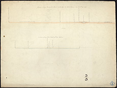
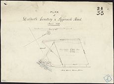
| Description: | Dalkieth. Dalkeith cemetry and approach road | |
| Year: | 1875 | |
| Place: | Dalkieth | |
| County: | Edinburgh | |
| Subject: | Road | |
| Inventory: | Drawing | |
| Colour: | Colour | |
| Media: | Graphite; Ink | |
| Object: | Flat | |
| Physical: | Paper | |
| Size: | 387 mm x 280 mm | |
| Shelfmark: | MS.5847, 3 | |
| Show location on map ? | ||
 | ||
| Zoom Into Map: | Click on the map to view in greater detail. | |