Your name search for McWilliam returned 9 records.
Ordered chronologically (undated items first).
| Name: | McWilliam, George | |
| Description: | Spynie, Loch. Part of Loch with canal | |
| Year: | 1832 | |
| Place: | Loch Spynie | |
| County: | Elgin | |
| Subject: | Canal | |
| Inventory: | Series of 2 drawings | |
| Colour: | Colour | |
| Media: | None | |
| Object: | Flat | |
| Physical: | Card | |
| Size: | 825 x 550 mm | |
| Shelfmark: | MS.5862, 103 - Mc | |
| Show location on map ? | ||
| Name: | McWilliam, George | |
| Description: | Spynie, Loch. Part of Loch with canal | |
| Year: | 1832 | |
| Place: | Loch Spynie | |
| County: | Elgin | |
| Subject: | Canal | |
| Inventory: | Series of 2 drawings | |
| Colour: | Colour | |
| Media: | None | |
| Object: | Flat | |
| Physical: | Card | |
| Size: | 555 x 820 mm | |
| Shelfmark: | MS.5862, 104 - Mc | |
| Show location on map ? | ||
| Name: | McWilliam, George ; Leslie, James, 1801-1889 ; Mitchell, James | |
| Description: | Burghead. Town and Harbour, and proposed extension of outer Pier | |
| Year: | 1837 | |
| Place: | Burghead | |
| County: | Elgin | |
| Subject: | Harbour | |
| Inventory: | Print by R.W. Hume | |
| Colour: | B&W | |
| Media: | Printed | |
| Object: | Flat | |
| Physical: | Paper | |
| Size: | 613 mm x 484 mm | |
| Shelfmark: | MS.5845, 84 | |
| Show location on map ? | ||
| Name: | McWilliam, George | |
| Description: | Lossiemouth. Plan and sections of Stotfield and Lossiemouth | |
| Year: | 1852 | |
| Place: | Lossiemouth | |
| County: | Elgin | |
| Subject: | Reference Material | |
| Inventory: | Drawing | |
| Colour: | Colour | |
| Media: | Graphite; Hand coloured; Ink | |
| Object: | Flat | |
| Physical: | Paper/Linen/Cloth | |
| Size: | 657 mm x 970 mm | |
| Shelfmark: | MS.5855, 65 | |
| Show location on map ? | ||
| Name: | McWilliam, George | |
| Description: | Lossiemouth. Plan of sea wall and pier-head | |
| Year: | 1853 | |
| Place: | Lossiemouth | |
| County: | Elgin | |
| Subject: | Harbour | |
| Inventory: | Drawing | |
| Colour: | Colour | |
| Media: | Hand coloured; Ink | |
| Object: | Flat | |
| Physical: | Paper/Linen/Cloth | |
| Size: | 750 mm x 660 mm | |
| Shelfmark: | MS.5855, 66 | |
| Show location on map ? | ||
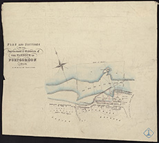
| Name: | McWilliam, George | |
| Description: | Port Gordon. Plan and sections for improvements and extension of harbour | |
| Year: | 1853 | |
| Place: | Portgordon | |
| County: | Banff | |
| Subject: | Harbour | |
| Inventory: | ||
| Colour: | Colour | |
| Media: | None | |
| Object: | Flat | |
| Physical: | Paper | |
| Size: | 370 x 420 mm | |
| Shelfmark: | MS.5859, 109 | |
| Show location on map ? | ||
 | ||
| Zoom Into Map: | Click on the map to view in greater detail. | |
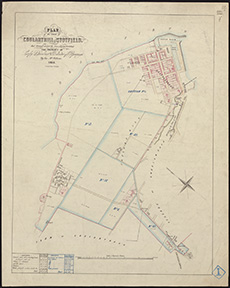
| Name: | McWilliam, George | |
| Description: | Lossiemouth. Plan of lands of Coularthill and Stotfield | |
| Year: | 1855 | |
| Place: | Lossiemouth | |
| County: | Elgin | |
| Subject: | Reference Material | |
| Inventory: | Series of 3 prints by W. Banks | |
| Colour: | Colour | |
| Media: | Hand coloured; Printed | |
| Object: | Flat | |
| Physical: | Paper | |
| Size: | 585 mm x 470 mm | |
| Shelfmark: | MS.5855, 67 | |
| Show location on map ? | ||
 | ||
| Zoom Into Map: | Click on the map to view in greater detail. | |
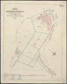
| Name: | McWilliam, George | |
| Description: | Lossiemouth. Plan of lands of Coularthill and Stotfield | |
| Year: | 1855 | |
| Place: | Lossiemouth | |
| County: | Elgin | |
| Subject: | Reference Material | |
| Inventory: | Series of 3 prints by W. Banks | |
| Colour: | Colour | |
| Media: | Hand coloured; Printed | |
| Object: | Flat | |
| Physical: | Paper | |
| Size: | 585 mm x 470 mm | |
| Shelfmark: | MS.5855, 68 | |
| Show location on map ? | ||
 | ||
| Zoom Into Map: | Click on the map to view in greater detail. | |
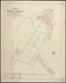
| Name: | McWilliam, George | |
| Description: | Lossiemouth. Plan of lands of Coularthill and Stotfield | |
| Year: | 1855 | |
| Place: | Lossiemouth | |
| County: | Elgin | |
| Subject: | Reference Material | |
| Inventory: | Series of 3 prints by W. Banks | |
| Colour: | Colour | |
| Media: | Hand coloured; Printed | |
| Object: | Flat | |
| Physical: | Paper | |
| Size: | 585 mm x 470 mm | |
| Shelfmark: | MS.5855, 69 | |
| Show location on map ? | ||
 | ||
| Zoom Into Map: | Click on the map to view in greater detail. | |