Project
Confirming and documenting the existence of each of the mills or associated features in the dataset were major tasks. Each record had to be viewed individually and the relevant data recorded accurately, being guided by both the time limit for the project and restrictions due to the Covid 19 pandemic.
First, the Ordnance Survey 1st and 2nd edition 6 inch to the mile maps and the 2nd edition 25 inch to the mile maps were imported to ArcMap as georeferenced layers. The 2nd edition 25 inch to the mile mapping was not produced for all of Scotland, just for more inhabited areas, so not all mill features could be checked on the 25 inch maps.) Each map was viewed in turn to address these questions:
- a. Is there a mill or associated feature on the maps?
- b. If the feature is not depicted on the maps, is its existence confirmed by Canmore?
If necessary, the location of the feature point was adjusted. Often this was required because the GB1900 project created features based on text which was placed adjacent to the mill rather than over it.
Then, if an associated Canmore record was assigned during the proximity querying process, a check was required to ensure that it had been linked to the correct mill feature.
The next step was to ascertain when the mill was operational, its power source, and the mill’s function. Sometimes this process was clear from the mapping; otherwise, further research was required:
- a. Looking at an associated Canmore record, if available
- b. If a mill feature was labelled with a specific name e.g. ‘Burnside Mill’, it could be searched for in the Ordnance Survey Name Books that accompany the 1st edition maps.
- c. If a. and b. did not provide the information, a web search was conducted. The websites of district councils and historical societies often contain records of local mills.
Depictions of mills on the Ordnance Survey Maps
Named Mills
For this project, the interpretation was that if a mill was named on the Ordnance Survey mapping and a function also given then the mill was operational at the time of the map being drawn. If there was only a name or if it was followed by “disused” or “ruins” then the mill was judged to no longer be in use. The example of Gartness Mill (below) would therefore be recorded as a woollen mill and also a watermill on both the 1st and 2nd edition maps.
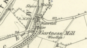
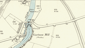
To test this procedure, the Ordnance Survey Name Books were consulted for a sample of mills and it was concluded that it was sufficiently reliable for the project. However, there are examples where no function is given on the map but it is probable that the mill was in fact operating. Conversely, there are others which are described as being disused in the Ordnance Survey Name Books but no indication of this is given on the maps. It is possible that there were regional differences in the depictions of mills on the Ordnance Survey maps since we have no record of the guidance given to the map surveyors.
Waterwheels
Occasionally a waterwheel was named on the map as was the case for the flour mill at Cultenhove and the Chartershall corn mill.
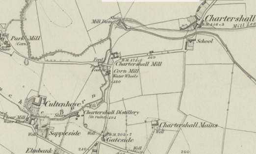
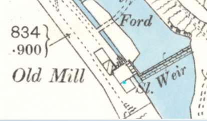
The wheel could also be depicted with a symbol although this level of detail tends to only be found at the scale of 25 inch to the mile.
Unnamed Mills
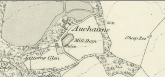
Where a mill dam or mill lade were depicted and named on a map without a named mill, this was recorded as a possible mill. This was particularly common in rural areas. Many are likely to have been farmsteads with their own water powered threshing mills.
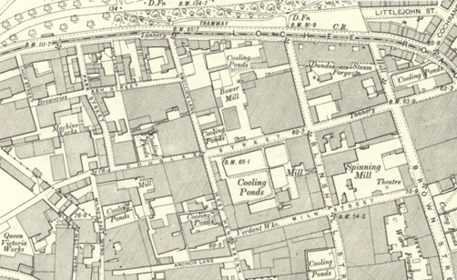
Mills would also be unnamed in urban, heavily built-up areas. For example, in central Dundee at 25 inch to the mile scale (see image below) many of the mill buildings are named, but at 6 inch to mile none of the mill buildings has been labelled. However, the level of detail is inconsistent even at 25 inch, providing specific names for some (Verdant Works, Queen Victoria Works) while using generic terms for others (Mill, Spinning Mill). Unless there was an associated Canmore record it was challenging to research these unnamed mills. Additional time to search online or consult physical archival materials may have identified unnamed mills but this was beyond the scope of this project.
Omissions
The aim of this project was to capture as many mills in Scotland as possible but there are certainly mills that have been missed unintentionally or by necessity. As has been noted, mills were included on the basis of four sources: the Canmore database; the GB1900 Gazeteer; the combined demo dataset; and later the georeferenced versions of the OS 1st edition map (6 inch to the mile), and the Ordnance Survey 2nd edition maps (6 inch and 25 inch to the mile). Errors and omissions from Canmore and GB1900 have unfortunately automatically been carried through to the project’s final ‘product’.
Threshing mills: Towards the end of this six-month project it became clear that it would not be possible to check through all of the data. It was decided to focus the remaining time on sites more likely to have been commercial mills (textile mills, corn mills, saw mills etc.), ignoring suspected threshing mills (identified on the maps by a mill dam near a farm). On this basis, eight counties with large numbers of possible threshing mills currently remain incomplete (Aberdeen, Angus, Banff, Berwick, Dumfries, Kincardine, Moray, Roxburgh).
Alternate methodologies: Use of different methodologies for locating mill sites will produce different results to the map displayed on this site.
For example, the Historical Journeys along British Rivers project by Tom Robertson and Alastair Robertson, has produced a dataset of watermills in catchments of the River Tyne (East Lothian) and the Water of Urr (Galloway). The project aimed to document watermills in existence between 1750 and early twentieth century. The sources used were similar to those of the Scottish Water Mills Project. They began with the 6 inch to the mile 1st edition OS maps before consulting the NLS’s digitised maps, printed texts, and web searches. The Robertsons worked systematically, identifying the mouth of a river on the 6 inch 1st edition OS map and working upstream along the main channel and all tributaries to record mill names, functions, and the millstream names encountered along the river. In contrast, the NLS mills data was extracted from a database and, for the most part, the stretches of river between data points were not examined.
The results of the Robertson's project display a good correlation with the Scottish Water Mills data for the given catchments. However, the Robertsons’ systematic methodology was able to record some mills that had closed prior to the 1st edition OS mapping as well as a number of threshing mills not identified by in the Scottish Water Mills Project.

