Pont maps | Pont texts | biographies | history | subjects | further reading
Place-names on Pont's maps
by Christopher Fleet and Dr. Simon Taylor
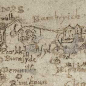
pronounced locally (Bambryich)
Timothy Pont's maps are an invaluable source of information about Scottish place-names.
Most obviously, they contain a large number of place-names. According to Jeffrey Stone, the manuscript and engraved maps collectively show over 20,000 individually named places (Stone, 1989, p.5).
Second, of greater importance, the maps are not only the earliest cartographic source for most of these names (therefore providing graphic information on their location) but also the earliest source of any kind, textual or graphic.
Third, Pont was a very diligent and detailed recorder: for some areas, there are not only more names than on any later mapping, but also names that do not appear in any other source (Taylor & Wentworth, 2001). For example, ylen Gewish or Eilean Giuthais ('Scots fir or pine island') in Loch Maree in Wester Ross (Pont 4), or Cunninghols in Fife [Gordon 54] can only be found on Pont maps. In general, Pont's place-name information was not surpassed until the Roy Military Survey and county maps of the 18th century.

Finally, Pont sometimes recorded the meaning of names, as when he notes Bhellachmaddy or Woolfs Way (probably for the Gaelic Bealach Madaidh, or 'Wolf's Pass', or less likely Bealach nam Madadh, 'Pass of the Wolves') on Pont 3 or when he writes Aalach is the yrish na[me] of atholl on Pont 20. Pont's description of Cunningham, 'Cunninghame Topographized' also records etymological information, often in the form of accurate and colourful descriptions, such as Achindarroch nether, vich Irisch or ancient Scotts vord signifies a fold or cast of manured soyle amongest oake trees, or vithin ane ocke voode (Fullarton, 1853, 9). (Achindarroch does in fact derive from Gaelic achadh an daraich, 'field of the oak', or acadh nan darach, 'field of the oaks').

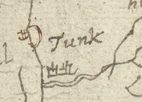
Of course, those using the maps for place-names must be wary of a few potential pitfalls. Pont's maps do contain occasional omissions of places known to exist in areas where the maps survive. Also, even if one adds to Pont's surviving manuscript maps the maps which Joan Blaeu had engraved for his great atlas of 1654, and which were largely based on Pont manuscript maps (some of which no longer survive), parts of Northern and Highland Scotland are only covered by maps containing relatively little detail and relatively few place-names. What is more, although Pont's handwriting for place-names is usually clear, not all names can be deciphered unambiguously, and the lack of standard forms for names in Pont's time often leads to different forms of the same name appearing on different maps (eg. Tunk and Tung for Tongue; Weemb and Weemh for Weems).

A number of recent projects have demonstrated the value of recording and studying place-names on Pont's maps, particularly by linking Pont's maps with later place-name sources and building historical gazetteers of Pont names. As Ruth Richens has shown for Clydesdale, recording place-names can also provide valuable clues to Pont's survey methods, and further conclusions can be drawn on the topographic accuracy of the maps by linking Pont's names to their modern equivalents (eg. Dumfriesshire, Stone, 1968; Eskdale and Ewesdale, Robinson, 1994). The National Library of Scotland's Map Library have been keen to co-ordinate research on Pont's place names to avoid duplication, as well as collate the results of particular research projects, and they can be contacted at maps@nls.uk. It is hoped that, in the future, this work can be brought together and built upon through the integration of place-name information in the emerging Scottish Place-Names Database, about which more information is available on the Scottish Place-Name Society website.
For a fuller discussion of the place of Pont in the study of Scottish placenames, see the chapter 'Pont and Place-Names' by Simon Taylor and Roy Wentworth in The Nation Survey'd, edited by Ian C. Cunningham.
