Ordnance Survey Characteristic Sheets - further information
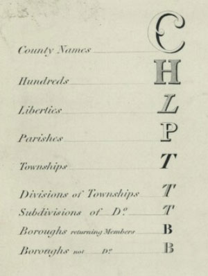
indicating fonts for particular features.
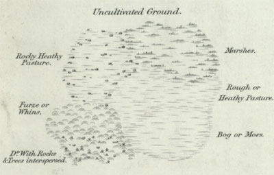
This set of printed items show the different symbols, features, styles for lettering, and stamps used on the main Ordnance Survey maps from the mid- to late- 19th century through to the 1920s. Through use of these sheets, especially in conjunction with a knowledge of Ordnance Survey’s own internal practices and its instructions to its own surveyors and draftsmen, we can reach a clearer understanding of the depiction of real-world features on OS maps at this time. These symbols and lettering styles emerged through the production of maps over a series of decades, and were not laid down as a fixed specification at the outset. In addition, the characteristics, as for the production of the maps, continued to evolve in response to a range of factors, including changing external requirements, the need to make economies, revised surveying practices, and new printing and production processes. The set was clearly used as an internal working collection within Ordnance Survey before its donation to the National Library of Scotland, and several of the items carry annotations by Ordnance Survey staff, usually noting when the document had been superseded.
Dating
Only 22 of these sheets carry a printed date on them. The earliest of these printed dates is 1847, whilst the rest of the printed dates are between 1897 and 1924. We hope to be able to offer better estimated dates in the future, based on the internal evidence of the detail on these sheets, knowledge of lettering styles, and by comparison with other states of these characteristics sheets from other libraries. It is likely that most of the sheets date from the 1890s to the 1920s. Only three of these Characteristics Sheets are listed in the earliest of the OS catalogues (1862) - two for the six-inch and one for the one-inch. It seems probable that they were regarded as only occasional and undated publications until the late 1890s, when there seems to have been a more concerted effort to create a set of consistent characteristics sheets for the main series from the six-inch to the ten-mile scales.
Related publications
(1897). Zoomable image.
Most of these sheets were produced as standalone sheets for reference purposes, but several others were printed for other publications, or intended to be read in conjunction with other publications. For example, the two editions of Character of Writing for Ordnance Survey Plans (OS 404) - 1881 (PDF, 9 Mb) and 1914 (PDF, 26 Mb), provide a practical explanation of the use of the Characters of the Writing sheets. The sketches to illustrate boundary mereings were ‘specially referred to in the 1914 Edition of Notes on Boundaries.’ Two of the sheets, numbered successively as ‘Plate I’ and ‘Plate IV’ were included in Ordnance Survey’s A description of the large scale maps of Great Britain produced and published by the Ordnance Survey, with specimens, symbol sheet, and diagrams. (1920 and later editions):
- Conventional Signs and Writing Used on the 1/2500 Plans of the Ordnance Survey. Plate I.
- Conventional Signs and Writing Used on the Six Inch Maps of the Ordnance Survey. Plate IV.
The use of symbols and lettering depicting antiquities are also explained in the Notes on Archaeology for Guidance in the Field, 1921 (PDF, 13 Mb). These were compiled by O.G.S. Crawford, (appointed as Ordnance Survey’s Archaeology Officer in 1920) and were reprinted several times over the following decades.
Provenance
It is believed that the original Characteristic Sheets volume was donated to the National Library of Scotland from Ordnance Survey in the late 1960s, along with the transfer of the main set of County Series record sheets at the same time from the Ordnance Survey’s store at Burley in Hampshire. More certainly, several decades earlier, the volume was used as a working set of symbols and lettering guides for consultation within Ordnance Survey for many years in the late 19th and early 20th centuries. Many of the sheets have been annotated by hand by an Ordnance Survey employee as to their currency or whether they were superseded. The latest annotations date from the 1920s, and so the collection would have related to set of maps that were all superseded by around the time of the Second World War.
The volume was not printed as a formal publication. Although some of the items within the collection were originally bound, others were physically stuck in or attached at various later times, and sometimes folded. The original binding for the volume was missing, and whilst some of the sheets were loose, others were attached in various gatherings, or with items stuck on top of each other. Conservation work in 2016 cleaned the sheets, removed glue where possible, and flattened pages to create a set of single flat sheets which were then digitised to make them available online.
References
Booth, J.R.S. (1980). Public Boundaries and Ordnance Survey, 1840-1980. Southampton?: Ordnance Survey.
Oliver, R. (2013). Ordnance Survey maps: a concise guide for historians. 3rd ed. London: Charles Close Society.
Ordnance Survey (1920 and later editions). A description of the large scale maps of Great Britain produced and published by the Ordnance Survey, with specimens, symbol sheet, and diagrams. Southampton: Ordnance Survey.
Winterbotham, H. St. J. L. (1934). The national plans (the ten-foot, five-foot, twenty-five-inch and six-inch scales). OS Professional Papers, New series, 16. London: HMSO.