Ordnance Survey Maps - Six-inch England and Wales, Special Emergency Edition
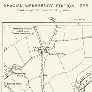
A set of 73 sheets, forming part of the 'Special Emergency Edition', a rapid revision in 1938-39 of the OS Six-Inch to the mile maps for Air Raid Precaution purposes. Most of the revision relates to new buildings and roads, with information obtained variously from One-Inch to the mile revision material, recent 25 inch to the mile revision, and some special surveys. Many sheets therefore show landscape detail which reflects much earlier revision in ca. 1900-25, juxtaposed with some building developments and roads which were very recent in 1939. Read further information on the Special Emergency Edition.
Although 3,058 Special Emergency Edition sheets were printed (covering all places with a population of over 2,000 people), the sheets were not sent to the Legal Deposit Libraries. We are very grateful to the Charles Close Society for donating these maps to NLS.
Browse the maps:
- These maps are available in the graphic index with our standard OS Six-Inch mapping (Filter by date to 1939:1939 to show these and other sheets printed/published in 1939)
- By map sheet number - see table below:
Sheet Number Date of Survey/Revision Date of Publication Cheshire VII.NE Revised: 1924 to 1925
Selected Revision: 1938Printed: 1939 Cheshire IX.NW Revised: 1904 to 1908
Selected Revision: 1938Printed: 1939 Cheshire IX.NE Revised: 1904 to 1908
Selected Revision: 1938Printed: 1939 Cheshire XI.SW Revised: 1896 to 1907
Selected Revision: 1938Printed: 1939 Cheshire XXII.NW Revised: 1908 to 1909
Selected Revision: 1938Printed: 1939 Cheshire XXII.SW Revised: 1909
Selected Revision: 1938Printed: 1939 Cheshire XXVIII.SE Revised: 1907
Selected Revision: 1938Printed: 1939 Cheshire XXIX.NW Revised: 1907
Selected Revision: 1938Printed: 1939 Cheshire XXXIII.SE Revised: 1908 to 1909
Selected Revision: 1938Printed: 1939 Cheshire XXXVI.SE Revised: 1907
Selected Revision: 1938Printed: 1939 Cheshire XXXVII.NW Revised: 1907
Selected Revision: 1938Printed: 1939 Cheshire XXXVII.SW Revised: 1907
Selected Revision: 1938Printed: 1939 Cheshire LI.NW Revised: 1907 to 1908
Selected Revision: 1938Printed: 1939 Cheshire LVI.NW Revised: 1908
Selected Revision: 1938Printed: 1939 Cheshire LVI.NE Revised: 1908
Selected Revision: 1938Printed: 1939 Cheshire LVI.SW Revised: 1908
Selected Revision: 1938Printed: 1939 Cheshire LVII.NW Revised: 1908
Selected Revision: 1938Printed: 1939 Durham I.SW Revised: 1914
Selected Revision: 1938Printed: 1939 Durham I.SE Revised: 1914
Selected Revision: 1938Printed: 1939 Durham II.SW Revised: 1913 to 1914
Selected Revision: 1938Printed: 1939 Durham III.NE Revised: 1913 to 1920
Selected Revision: 1938Printed: 1939 Durham III.SW Revised: 1912 to 1913
Selected Revision: 1938Printed: 1939 Durham IV.NW Revised: 1912 to 1920
Selected Revision: 1938Printed: 1939 Durham XVIII.NE Revised: 1919
Selected Revision: 1938Printed: 1939 Durham XIX.NW Revised: 1915
Selected Revision: 1938Printed: 1939 Durham XIX.NE Revised: 1915
Selected Revision: 1938Printed: 1939 Durham XXV.SE Revised: 1915 to 1916
Selected Revision: 1938Printed: 1939 Durham XXVII.SW Revised: 1915
Selected Revision: 1938Printed: 1939 Durham XXXIII.NE Revised: 1916 to 1919
Selected Revision: 1938Printed: 1939 Durham XXXIII.SE Revised: 1915 to 1919
Selected Revision: 1938Printed: 1939 Durham XXXV.NW Revised: 1915
Selected Revision: 1938Printed: 1939 Durham XLII.SW Revised: 1914 to 1915
Selected Revision: 1938Printed: 1939 Durham XLII.NW Revised: 1915
Selected Revision: 1938Printed: 1939 Durham XLII.NE Revised: 1915
Selected Revision: 1938Printed: 1939 Durham XLII.SE Revised: 1914 to 1915
Selected Revision: 1938Printed: 1939 Flintshire VI.NW Revised: 1910
Selected Revision: 1938Printed: 1939 Flintshire X.SW Revised: 1909 to 1910
Selected Revision: 1938Printed: 1939 Northumberland nII.SW Revised: 1922 to 1923
Selected Revision: 1938Printed: 1939 Northumberland nIV.NW Revised: 1922
Selected Revision: 1938Printed: 1939 Northumberland nXXXV.NW Revised: 1921 to 1922
Selected Revision: 1938Printed: 1939 Northumberland nXLIV.SW Revised: 1921
Selected Revision: 1938Printed: 1939 Northumberland nXLIV.NW Revised: 1921 to 1922
Selected Revision: 1938Printed: 1939 Northumberland nLXI.SW Revised: 1921
Selected Revision: 1938Printed: 1939 Northumberland nLXI.SE Revised: 1921
Selected Revision: 1938Printed: 1939 Northumberland nLXIX.NW Revised: 1921
Selected Revision: 1938Printed: 1939 Northumberland nLXIX.NE Revised: 1921
Selected Revision: 1938Printed: 1939 Northumberland nLXIX.SW Revised: 1921
Selected Revision: 1938Printed: 1939 Northumberland nLXIX.SE Revised: 1921
Selected Revision: 1938Printed: 1939 Northumberland nLXX.NW Revised: 1921
Selected Revision: 1938Printed: 1939 Northumberland nLXX.NE Revised: 1921
Selected Revision: 1938Printed: 1939 Northumberland nLXX.SW Revised: 1920 to 1921
Selected Revision: 1938Printed: 1939 Northumberland nLXX.SE Revised: 1921
Selected Revision: 1938Printed: 1939 Northumberland nLXXVII.NE Revised: 1920 to 1921
Selected Revision: 1938Printed: 1939 Northumberland nLXXVII.SE Revised: 1920
Selected Revision: 1938Printed: 1939 Northumberland nLXXVIII.NW Revised: 1920
Selected Revision: 1938Printed: 1939 Northumberland nLXXVIII.NE Revised: 1920 to 1921
Selected Revision: 1938Printed: 1939 Northumberland nLXXVIII.SW Revised: 1920
Selected Revision: 1938Printed: 1939 Northumberland nLXXVIII.SE Revised: 1920
Selected Revision: 1938Printed: 1939 Northumberland nLXXXV.NE Revised: 1913
Selected Revision: 1938Printed: 1939 Northumberland nLXXXV.SE Revised: 1913
Selected Revision: 1938Printed: 1939 Northumberland nLXXXVI.NW Revised: 1913 to 1914
Selected Revision: 1938Printed: 1939 Northumberland nLXXXVI.NE Revised: 1913 to 1921
Selected Revision: 1938Printed: 1939 Northumberland nLXXXVI.SW Revised: 1913
Selected Revision: 1938Printed: 1939 Northumberland nLXXXVI.SE Revised: 1913
Selected Revision: 1938Printed: 1939 Northumberland nLXXXVII.SW Revised: 1913 to 1914
Selected Revision: 1938Printed: 1939 Northumberland nXCI.SE Revised: 1920
Selected Revision: 1938Printed: 1939 Northumberland nXCIII.NE Revised: 1913
Selected Revision: 1938Printed: 1939 Shropshire I.SE Revised: 1908 to 1924
Selected Revision: 1938Printed: 1939 Shropshire VIII.NW Revised: 1924
Selected Revision: 1938Printed: 1939 Shropshire XII.NE Revised: 1924
Selected Revision: 1938Printed: 1939 Staffordshire III.SW Revised: 1907 to 1922
Selected Revision: 1938Printed: 1939 Staffordshire XXIV.NW Revised: 1922
Selected Revision: 1938Printed: 1939 Staffordshire XXIV.NE Revised: 1922
Selected Revision: 1938Printed: 1939