Military Maps of Scotland (18th century)
Your search returned 252 records.
Ordered chronologically (undated items first).
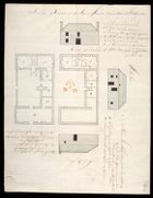
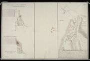
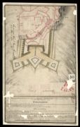
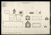
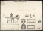
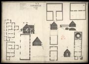
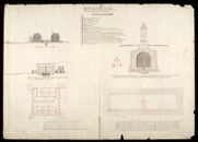
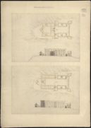
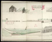
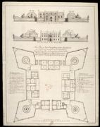
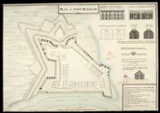
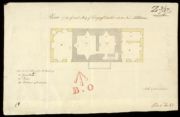
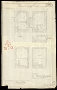
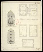
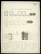
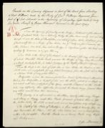
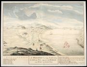
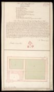
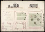
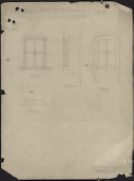
| Title: | A Plan & Elevation of Mr Stewart's House, the Barrack-master at Fort Augustus. | |
| Name: | [Clark or Carte, Thomas] [Storekeeper - name in bottom left corner] | |
| Shelfmark: | MS.1650 Z.46/59 | |
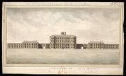
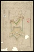
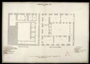
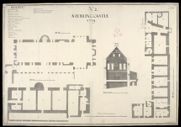
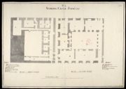
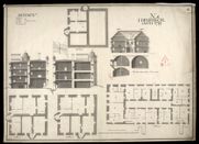
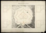
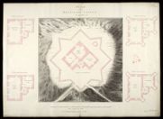
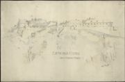
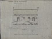
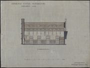
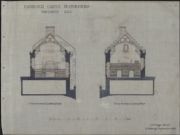
| Title: | North Elevation of Gordon Castle | |
| Name: | Carte (Clark?), Thomas [Storekeeper] | |
| Shelfmark: | MS.1650 Z.46/63 | |
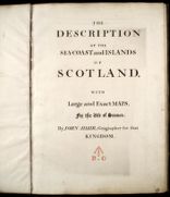
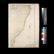
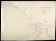
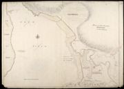
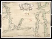
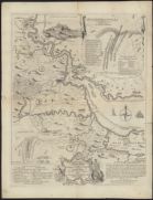
| Title: | The Description of the Sea-Coast and Islands of Scotland with Large and Exact Maps for the Use of Seamen [manuscript copy of title page] | |
| Name: | Adair, John | |
| Survey: | 1703 | |
| Shelfmark: | MS.1651 Z.69/01 | |
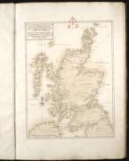
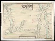
| Title: | A true and exact Hydrographical description of the Sea Coast and Isles of Scotland Made in Voyage round the same by that great and mighty Prince James the 5th.[mansucript copy] | |
| Name: | Adair, John | |
| Survey: | 1703 | |
| Shelfmark: | MS.1651 Z.69/01 | |
| Title: | Holy-Island Fairn Islands with the many Rocks and Hazards that lye Scatter'd in that Sea And the Coast from Sunderland point in England to St Abbs-head in Scotland [manuscript copy] | |
| Name: | Adair, John | |
| Survey: | 1703 | |
| Shelfmark: | MS.1651 Z.69/01 | |
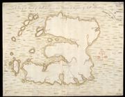
| Title: | The Frith of Forth; From the Entry to the Queen's-ferry, with all the Islands, Rocks, Sands, &c.[manuscript copy] | |
| Name: | Adair, John | |
| Survey: | 1703 | |
| Shelfmark: | MS.1651 Z.69/01 | |
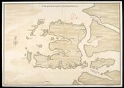
| Title: | The Frith and River of Tay with all the Rocks, Sands, Shoals, &c..[manuscript copy] | |
| Name: | Adair, John | |
| Survey: | 1703 | |
| Shelfmark: | MS.1651 Z.69/01 | |
| Title: | The Town and Water of Montross with the neighbouring Country & Coast from the Red-head to the North-water [mansucript copy] | |
| Name: | Adair, John | |
| Survey: | 1703 | |
| Shelfmark: | MS.1651 Z.69/01 | |
| Title: | The Coast of Scotland from the Red-head to Aberdeen [manuscript copy] | |
| Name: | Adair, John | |
| Survey: | 1703 | |
| Shelfmark: | MS.1651 Z.69/01 | |
| Title: | Sterling Castle | |
| Name: | Dury, Theodore (Engineer) | |
| Survey: | [1708] | |
| Shelfmark: | MS.1646 Z.02/16a | |
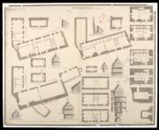
| Title: | [Stirling Castle, showing plans to fortify the main entrance and the nether bailey] | |
| Name: | Dury, Theodore (Engineer) | |
| Survey: | [1708?] | |
| Shelfmark: | MS.1646 Z.02/16b | |
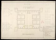
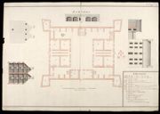
| Title: | Ground Floor of the Palace at Stirling Castle | |
| Name: | Dury, Theodore (Engineer) | |
| Survey: | [1708] | |
| Shelfmark: | MS.1646 Z.02/17 | |
| Title: | A Plan of Sterling Castle, as here Colour'd in Red lines, and the Black is a Design for better Fortifying the Entrance of the same; A profile of Elphinstons Tower and French Spur at Sterling Castle | |
| Name: | Dury, Theodore (Engineer) Edwards, Talbot (Engineer) | |
| Survey: | 1708 | |
| Shelfmark: | MS.1646 Z.02/23a | |
| Title: | A Plan of Sterling Castle, as here Color'd in Red lines, and the Black is a Design for better Fortifying the Entrance of the same; A profile of Elphinstons Tower and French Spur at Sterling Castle [1708] [copy] | |
| Name: | Dury, Theodore (Engineer) Edwards, Talbot (Engineer) Beaumont, John (Copyist) | |
| Survey: | [1708] | |
| Shelfmark: | MS.1646 Z.02/23b | |
| Title: | A Plan of Sterling Castle, as here Color'd in Red lines, and the Black is a Design for better Fortifying the Entrance of the same; A profile of Elphinstons Tower and French Spur at Sterling Castle [1708] [copy] | |
| Name: | Dury, Theodore (Engineer) Edwards, Talbot (Engineer) | |
| Survey: | [1708?] | |
| Shelfmark: | MS.1646 Z.02/23c | |
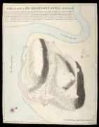
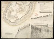
| Title: | A Draught of Dumbarton Castle Anno 1708 | |
| Name: | [Dury, Theodore (Engineer)] | |
| Survey: | 1708 | |
| Shelfmark: | MS.1647 Z.02/71a | |
| Title: | A Draught of Dumbarton Castle Anno 1708 [copy] | |
| Name: | Field, John (Copyist) | |
| Survey: | 1708 | |
| Shelfmark: | MS.1647 Z.02/71b | |
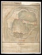
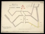
| Title: | A Plan of the Castle of Dunbarton and the repairs requisite to be done there 1709 | |
| Name: | O 'Brien, John (Engineer) | |
| Survey: | 1709 | |
| Shelfmark: | MS.1647 Z.02/72 | |
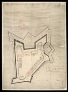
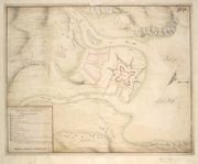
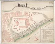
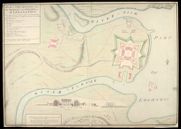
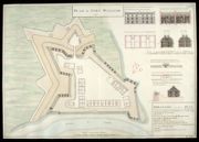
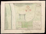
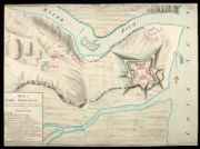
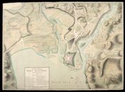
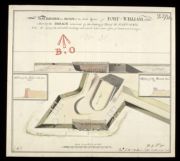
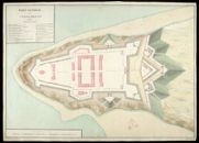
| Title: | Plan of Fort William at Inverlochy in its present condition Augst. 1709 | |
| Name: | [Dury, Theodore (Engineer)] | |
| Survey: | 1709 | |
| Shelfmark: | MS.1646 Z.02/24c | |
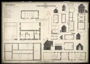
| Title: | A Plan of Edinburgh Castle | |
| Name: | Edwards, Talbot (Engineer) | |
| Survey: | 1709 | |
| Shelfmark: | MS.1649 Z.03/58a | |
| Title: | Plan of the Works proposed to be made at the Castle of Edinburgh | |
| Name: | Dury, Theodore (Engineer) | |
| Survey: | 1709 | |
| Shelfmark: | MS.1649 Z.03/58b | |
| Title: | A Designe for better Securing the Entrance into Edinburgh Castle 1710 | |
| Name: | Edwards, Talbot (Engineer) | |
| Survey: | 1710 | |
| Shelfmark: | MS.1649 Z.03/58c | |
| Title: | Profil of the flanck proposed to be made at the West End of the new Wall at the Castle of Edinburgh | |
| Name: | Edwards, Talbot (Engineer) | |
| Survey: | 1710 | |
| Shelfmark: | MS.1649 Z.03/58d | |
| Title: | A Profile to my Design for the better Fortifying Edinburgh Castle, with a Hornwork, and Retrenchments within the same November 1710 | |
| Name: | Edwards, Talbot (Engineer) | |
| Survey: | 1710 | |
| Shelfmark: | MS.1649 Z.03/58e | |

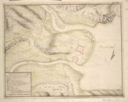
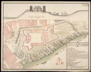
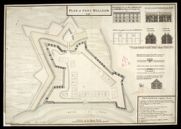
| Title: | Plan of Fort William with the country adjacent | |
| Name: | Johnson, Robert (Overseer) | |
| Survey: | [ca.1710] | |
| Shelfmark: | MS.1646 Z.02/24a | |
| Title: | Plan of Fort William at Inverlochie in Lochaber | |
| Name: | [Dury, Theodore (Engineer)] | |
| Survey: | [ca.1710] | |
| Shelfmark: | MS.1646 Z.02/24b | |
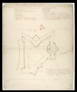
| Title: | An Exact Plan of the Town and adjacent parts of Perth as it was fortified and possess'd by the Rebells in Scotland till they were driven thence by the Victorious Arm of King George, Anno 1715/6. | |
| Name: | Horneck, William (Engineer) | |
| Survey: | 1715-16 | |
| Shelfmark: | MS.1647 Z.03/02a | |
| Title: | An Exact Plan of the Town and Adjacent parts of Perth as it was Fortified and Possess'd by the Rebells in Scotland till they were driven thence, by the Victorious Arms of King George Anno 1715/6 [copy]. | |
| Name: | Horneck, William (Engineer) | |
| Survey: | 1715-16 | |
| Shelfmark: | MS.1647 Z.03/02b | |
| Title: | An Exact Plan of the Town and adjacent parts of Perth as it was fortified and possess'd by the Rebells in Scotland till they were driven thence by the Victorious Arms of King George Anno 1715/6 [copy]. | |
| Name: | Horneck, William (Engineer) | |
| Survey: | 1715-16 | |
| Shelfmark: | MS.1647 Z.03/02c | |
| Title: | A Plan of the Two Carrinburghs drawen on the place | |
| Name: | Johnson, Robert (Overseer) | |
| Survey: | [1717] | |
| Shelfmark: | MS.1648 Z.03/24a | |
| Title: | The Roads between Innersnait Ruthvan of Badenock Kiliwhiman and Fort William in ye highlands of North Brittain | |
| Name: | Dumaresq, John & Bastide, John Henri (Engineer) Bastide, John Henri (Draughtsman) | |
| Survey: | 1718 | |
| Shelfmark: | MS.1648 Z.03/13a | |
| Title: | The Roads between Innersnait Ruthvan of Badenock Kiliwhiman and Fort William in the highlands of North Brittian [1718] [copy] | |
| Name: | Dumaresq, John & Bastide, John Henri (Engineer) Bastide, John Henri (Draughtsman) | |
| Survey: | 1718 | |
| Shelfmark: | MS.1648 Z.03/13b | |
| Title: | A Draught of Innersnait, in the Highlands of North Brittain, nere the Head of Loch Lomend with part of the country adjacent [copy] | |
| Name: | Dumaresq, John & Bastide, John Henri (Engineer) Bastide, John Henri (Draughtsman) | |
| Survey: | [1718] | |
| Shelfmark: | MS.1648 Z.03/15a | |
| Title: | A Plan of the Barrack at Kiliwhiman And of the Ground within the bounds of it betwixt the two Rivers & the letters AB.C | |
| Name: | Dumaresq, John & Bastide, John Henri (Engineer) Bastide, John Henri (Draughtsman) | |
| Survey: | 1718 | |
| Shelfmark: | MS.1647 Z.03/08a | |
| Title: | A Plan of ye Barrack at Kiliwhiman and of the Ground within the Bounds of it betwixt the Two Rivers; and the Letters A.B.C [copy] | |
| Name: | Dumaresq, John & Bastide, John Henri (Engineer) Bastide, John Henri (Draughtsman) | |
| Survey: | 1719 | |
| Shelfmark: | MS.1647 Z.03/08b | |
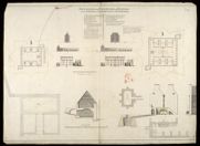
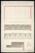
| Title: | Plan, Section and Elevation of the Barrack at Inveersnait and Kiliwhiman [with] Explanation; Powder Magasine at Edinbgh. Castle and Section of the Same at x; with a project of Arching the second Floor at y | |
| Name: | Romer, John Lambertus (Engineer) | |
| Survey: | [1719] | |
| Shelfmark: | MS.1647 Z.03/11a | |
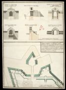
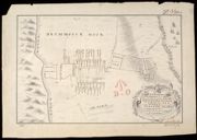
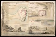
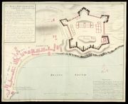
| Title: | Plan of the Fort Barrack of Bernera in Glen Elg 1719 | |
| Name: | Bastide, John Henri (Engineer) | |
| Survey: | 1719 | |
| Shelfmark: | MS.1647 Z.03/06b | |
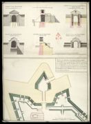
| Title: | Plan of the Fort Barrack of Bernera in Glen Elg 1719 [copy] | |
| Name: | Bastide, John Henri (Engineer) | |
| Survey: | 1719 | |
| Shelfmark: | MS.1647 Z.03/06c | |
| Title: | Plan of the Fort Barrack Bernera in Glen Elg [1719] [copy] | |
| Name: | Bastide, John Henri (Engineer) | |
| Survey: | 1719 | |
| Shelfmark: | MS.1647 Z.03/06d | |
| Title: | Barnera [1719] | |
| Name: | Bastide, John Henri (Engineer) | |
| Survey: | 1719 | |
| Shelfmark: | MS.1647 Z.03/05a | |
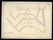
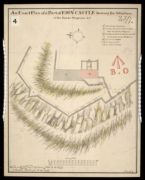
| Title: | Dunbarton Anno 1719 | |
| Name: | Jelfe, Andrews (Architect) Moore, Thomas (Engineer) | |
| Survey: | 1719 | |
| Shelfmark: | MS.1647 Z.02/73 | |
| Title: | A Draught of Innersnait, in the Highlands of North Brittain, nere the Head of Loch Lomend with part of the country adjacent | |
| Name: | Dumaresq, John & Bastide, John Henri (Engineer) Bastide, John Henri (Draughtsman) | |
| Survey: | 1719 | |
| Shelfmark: | MS.1648 Z.03/15b | |
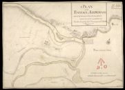
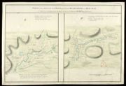
| Title: | A Plan of the Field of Battle that was fought on ye 10th of Iune 1719, at the Pass of Glenshiels in Kintail North Britain with ye Disposition of his Majtys Forces under ye Command of Majr. Genl. Wightman, & of those of ye Rebels | |
| Name: | Bastide, John Henri (Engineer) | |
| Survey: | 1719 | |
| Shelfmark: | MS.1648 Z.03/22a | |
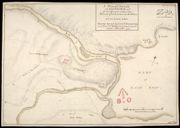
| Title: | A Plan of the Field of Battle that was fought on the 10th of Iune 1719, at the Pass of Glenshiels in Kintail North Britain with ye Disposition of his Majtys Forces under ye Command of Majr. Genl. Wightman, & of those of ye Rebels [copy] | |
| Name: | Bastide, John Henri (Engineer) | |
| Survey: | [1719?] | |
| Shelfmark: | MS.1648 Z.03/22b | |
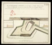
| Title: | Fort William, Anno 1719 [No.1] | |
| Name: | Jelfe, Andrews (Architect) Moore, Thomas (Engineer) | |
| Survey: | 1719 | |
| Shelfmark: | MS.1646 Z.02/26a | |
| Title: | Fort William, Anno 1719 [No.1] [copy] | |
| Name: | Jelfe, Andrews (Architect) Moore, Thomas (Engineer) Dodd, Pressick (Copyist) | |
| Survey: | 1719 | |
| Shelfmark: | MS.1646 Z.02/26b | |
| Title: | Fort William, Anno 1719 [No.2] | |
| Name: | Jelfe, Andrews (Architect) Moore, Thomas (Engineer) | |
| Survey: | 1719 | |
| Shelfmark: | MS.1646 Z.02/26c | |
| Title: | Sterling Castle, No. 1, [copy] 1741 | |
| Name: | Jelfe, Andrews (Architect) Moore, Thomas (Engineer) | |
| Survey: | [1719] | |
| Shelfmark: | MS.1646 Z.02/22a | |
| Title: | Sterling Castle, No. 2, [copy] 1741 | |
| Name: | Jelfe, Andrews (Architect) Moore, Thomas (Engineer) | |
| Survey: | [1719] | |
| Shelfmark: | MS.1646 Z.02/22b | |
| Title: | Sterling Castle, No. 3, [copy] 1741 | |
| Name: | Jelfe, Andrews (Architect) Moore, Thomas (Engineer) | |
| Survey: | [1719] | |
| Shelfmark: | MS.1646 Z.02/22c | |
| Title: | Sterling Castle, No. 4 [copy 1741] | |
| Name: | Jelfe, Andrews (Architect) Moore, Thomas (Engineer) | |
| Survey: | [1719] | |
| Shelfmark: | MS.1646 Z.02/22d | |
| Title: | Sterling Castle, November 1719. No.1: Plan of the 3d Stage at A in the Section | |
| Name: | Jelfe, Andrews (Architect) Moore, Thomas (Engineer) | |
| Survey: | 1719 | |
| Shelfmark: | MS.1646 Z.02/18a | |
| Title: | Sterling Castle, [November] 1719, No.2 | |
| Name: | Jelfe, Andrews (Architect) Moore, Thomas (Engineer) | |
| Survey: | 1719 | |
| Shelfmark: | MS.1646 Z.02/18b | |
| Title: | Sterling Castle, Novemr 1719, No.3 | |
| Name: | Jelfe, Andrews (Architect) Moore, Thomas (Engineer) | |
| Survey: | 1719 | |
| Shelfmark: | MS.1646 Z.02/18c | |
| Title: | Sterling Castle, Novembr: 1719, No.4 | |
| Name: | Jelfe, Andrews (Architect) Moore, Thomas (Engineer) | |
| Survey: | 1719 | |
| Shelfmark: | MS.1646 Z.02/18d | |
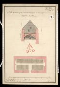
| Title: | No. 1, Edinburgh Castle, 1719. | |
| Name: | Jelfe, Andrews (Architect) Moore, Thomas (Engineer) | |
| Survey: | 1719 | |
| Shelfmark: | MS.1645 Z.02/01a | |
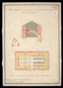
| Title: | No. 2, Edinburgh Castle, 1719. | |
| Name: | Jelfe, Andrews (Architect) Moore, Thomas (Engineer) | |
| Survey: | 1719 | |
| Shelfmark: | MS.1645 Z.02/01b | |
| Title: | No. 3, Edinburgh Castle, 1719. | |
| Name: | Jelfe, Andrews (Architect) Moore, Thomas (Engineer) | |
| Survey: | 1719 | |
| Shelfmark: | MS.1645 Z.02/01c | |
| Title: | No. 4, Edinburgh Castle, 1719. | |
| Name: | Jelfe, Andrews (Architect) Moore, Thomas (Engineer) | |
| Survey: | 1719 | |
| Shelfmark: | MS.1645 Z.02/01d | |
| Title: | No. 5, Edinburgh Castle, 1719. | |
| Name: | Jelfe, Andrews (Architect) Moore, Thomas (Engineer) | |
| Survey: | 1719 | |
| Shelfmark: | MS.1645 Z.02/01e | |
| Title: | [Plan of the Battle of Sheriffmuir, fought 13 November 1715] [copy] | |
| Name: | [Lascelles, Thomas (Engineer)] | |
| Survey: | [1719?] | |
| Shelfmark: | MS.1649 Z.03/45c | |
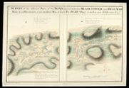
| Title: | A disposition of His Maj:ties Forces command'd by Majr. Genl. Wightman & of ye Rebells at ye Pass of Glenshiells in Kintail ... where ye battle was fought on ye 10th of June 1719 ... / by John Bastide. | |
| Name: | Bastide, John. | |
| Survey: | 1719 | |
| Shelfmark: | EMS.s.163 | |
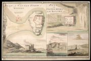
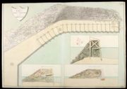
| Title: | A Prospect of that Part of the Land and Sea adjacent to ye Barrack to be Built in Glen Elg | |
| Name: | Bastide, John Henri (Engineer) | |
| Survey: | 1720 | |
| Shelfmark: | MS.1647 Z.03/07a | |
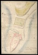
| Title: | Plan and Section of the Kings House and Garden at Perth | |
| Name: | Romer, John Lambertus (Engineer) | |
| Survey: | 1723 | |
| Shelfmark: | MS.1647 Z.03/03a | |
| Title: | Plan Section and Elevation of the Barracks at Killiwhimen with a particular Plan and Section of the Cistern. | |
| Name: | Romer, John Lambertus (Engineer) | |
| Survey: | 1723 | |
| Shelfmark: | MS.1647 Z.03/12a | |
| Title: | Plan Section and Elevation of the barracks at Killiwhimen, with a particular plan and section of the cistern [1723] [copy] | |
| Name: | Romer, John Lambertus (Engineer) | |
| Survey: | 1723 | |
| Shelfmark: | MS.1647 Z.03/12c | |
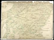
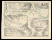
| Title: | [Map of Scotland showing the Forts at Inverness, Fort Augustus, Fort William and Moidart and on which is pencilled the proposed military roads, also the names and numbers of men that could be raised by the various clans] | |
| Name: | [Wade, George (Engineer)] | |
| Survey: | [ca. 1724-45?] | |
| Shelfmark: | Acc.10497 Wade.58a | |
| Title: | A Map of Part of the Highlands, not done by actual Survey, but laid down on the common computed distances of places … | |
| Name: | [Wade, George (Engineer)] | |
| Survey: | [ca. 1724-45?] | |
| Shelfmark: | Acc.10497 Wade.58c | |
| Title: | [Map showing the intended military roads joining up Stirling with Fort Augustus, etc.] | |
| Name: | [Wade, George (Engineer)] | |
| Survey: | [ca. 1724-45?] | |
| Shelfmark: | Acc.10497 Wade.58e | |
| Title: | A Plan of Killiwhymen [Fort Augustus] … | |
| Name: | Debize, R. [Wade, George (Engineer)] | |
| Survey: | [ca. 1724-45?] | |
| Shelfmark: | Acc.10497 Wade.58f | |

| Title: | A plan of the Barracks of Killiwhymen and of the Ground about it... | |
| Name: | Debize, R. [Wade, George (Engineer)] | |
| Survey: | 10 February 1724-5 | |
| Shelfmark: | Acc.10497 Wade.58g | |
| Title: | [Plan of Fort] | |
| Name: | [Wade, George (Engineer)] | |
| Survey: | [ca. 1724-45?] | |
| Shelfmark: | Acc.10497 Wade.58k | |
| Title: | [Plans and elevation of the Earl of Gowrie's House, Perth] | |
| Name: | [Wade, George (Engineer)] | |
| Survey: | [ca. 1724-45?] | |
| Shelfmark: | Acc.10497 Wade.58l | |
| Title: | [Sketch and description of the proposed Roads from Callander and Loch Tay to Fort William and Appin including details of mileage and of inns] | |
| Name: | [Wade, George (Engineer)] | |
| Survey: | [ca. 1724-45?] | |
| Shelfmark: | Acc.10497 Wade.58m | |
| Title: | [Plan of Fort and Barracks - Killiwhymen?] [CA thinks Ruthven] | |
| Name: | [Wade, George (Engineer)] | |
| Survey: | [ca. 1724-45?] | |
| Shelfmark: | Acc.10497 Wade.58n | |
| Title: | A Plan of the Town and Castle of Sterling 1725 | |
| Name: | Laye, John (Copyist) | |
| Survey: | 1725 | |
| Shelfmark: | MS.1646 Z.02/19a | |
| Title: | A Plan of the Town and Castle of Sterling 1740 [copy] | |
| Name: | Chamberlaine, Augustus H. (Copyist) | |
| Survey: | [1725] | |
| Shelfmark: | MS.1646 Z.02/21b | |
| Title: | Plan of Edinburgh Castle [1725] | |
| Name: | Moore, Thomas (Draughtsman) | |
| Survey: | [1725] | |
| Shelfmark: | MS.1645 Z.02/03a | |
| Title: | [Plan of Edinburgh Castle] [1725] [copy] | |
| Name: | Moore, Thomas (Draughtsman) Roe, Robert (Copyist) | |
| Survey: | [1725] | |
| Shelfmark: | MS.1645 Z.02/03b | |
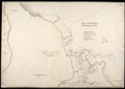
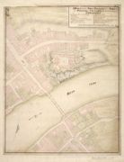
| Title: | A General Survey of Inverness, and the Country adjacent to the foot of Loch-Ness; [inset] West Prospect of Inverness | |
| Name: | Bastide, John Henri (Engineer) | |
| Survey: | [ca.1725] | |
| Shelfmark: | MS.1647 Z.02/76a | |
| Title: | A General Survey of Inverness, & the Country adjacent to the Foot of Loch-Ness [copy] | |
| Name: | Bastide, John Henri (Engineer) | |
| Survey: | [ca.1725] | |
| Shelfmark: | MS.1647 Z.02/76b | |
| Title: | A Generall Survey of Inverness, & the country adjacent to the foot of Loch-Ness [copy] | |
| Name: | Bastide, John Henri (Engineer) | |
| Survey: | [ca.1725] | |
| Shelfmark: | MS.1647 Z.02/76c | |
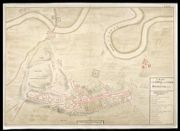
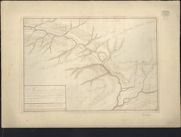
| Title: | This Plan containing Lochness Lochoyoch, Lochlochey, & all the Rivers and Strips of water that Runs in & set out from the same, from the East Sea before Inverness to the West Sea at Inverlochey before Fort William, together with all Roads & Remarkable pla | |
| Name: | Avery, Joseph | |
| Survey: | [ca.1727] | |
| Shelfmark: | MS.1648 Z.03/21 | |
| Title: | [Plan of] District of Fort Wm. | |
| Name: | [Wade, George (Engineer)] | |
| Survey: | 1728 | |
| Shelfmark: | Acc.10497 Wade.58i | |
| Title: | A plan of part of the town of Inverness with a project for Barracks on Castle Hill … | |
| Name: | Romer, John Lambertus (Engineer) [Wade, George (Engineer)] | |
| Survey: | 1728 | |
| Shelfmark: | Acc.10497 Wade.58j | |
| Title: | Fort William; Fort Augustus; Fort George, Inverness | |
| Name: | Romer, John Lambertus (Engineer) Jackson, Leonard (Draughtsman) | |
| Survey: | [ca.1729-46] | |
| Shelfmark: | MS.1646 Z.02/31c | |
| Title: | A plan of the intended Fortress with the Situation of Killiwhymen | |
| Name: | Romer, John Lambertus (Engineer) [Wade, George (Engineer)] | |
| Survey: | [1729?] | |
| Shelfmark: | Acc.10497 Wade.58h | |
| Title: | A Plan of Kiliwhymen where Fort Augustus is situated | |
| Name: | [Wade, George (Engineer)] | |
| Survey: | 1729 | |
| Shelfmark: | Acc.10497 Wade.58h | |
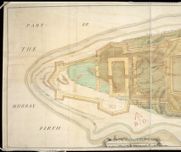
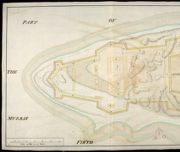
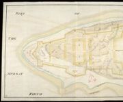
| Title: | [Plan of the Murray Firth and Cromarty Firth, with parts of the Shires of Inverness, Sutherland, Ross, Nairn, and Elgin. Showing roads] | |
| Name: | [Avery, Joseph Wade, George (Engineer)] | |
| Survey: | 1730 | |
| Shelfmark: | Acc.10497 Wade.58d | |
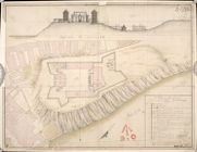
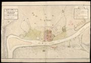
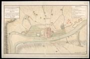
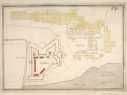
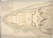
| Title: | A Plan of Fort George wth part of the Town of Inverness 1730 | |
| Name: | Romer, John Lambertus (Engineer) | |
| Survey: | 1730 | |
| Shelfmark: | MS.1646 Z.02/33a | |
| Title: | A Plan of Fort George with Part of the Town of Inverness [1730] [copy] | |
| Name: | Romer, John Lambertus (Engineer) | |
| Survey: | [1730] | |
| Shelfmark: | MS.1646 Z.02/33b | |
| Title: | A Plan of Fort George with part of the Town of Inverness 1730 [copy] | |
| Name: | Romer, John Lambertus (Engineer) | |
| Survey: | 1730 | |
| Shelfmark: | MS.1646 Z.02/33c | |
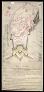
| Title: | A Description of Part of the Highlands of Scotland [showing clans which rebelled in 1715] | |
| Name: | Manson, John (Draughtsman) | |
| Survey: | [ca.1731] | |
| Shelfmark: | MS.1649 Z.03/41a | |
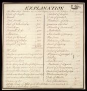
| Title: | Explanation [of 'A Description of Part of the Highlands of Scotland', showing clans which rebelled in 1715] | |
| Name: | Manson, John (Draughtsman) | |
| Survey: | [ca.1731] | |
| Shelfmark: | MS.1649 Z.03/41b | |
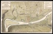
| Title: | A Plan of Fort George, & part of the Town of Inverness, with proper Sections relating to the Fort. Anno 1732. | |
| Name: | Romer, John Lambertus (Engineer) | |
| Survey: | 1732 | |
| Shelfmark: | MS.1646 Z.02/34a | |
| Title: | A Plan of Fort George and part of the Town of Inverness, with proper Sections relating to the Fort. Anno 1732 [copy] | |
| Name: | Romer, John Lambertus (Engineer) | |
| Survey: | 1732 | |
| Shelfmark: | MS.1646 Z.02/34b | |
| Title: | Profiles and Elevations Relating to the Plan of Fort William, 1733 | |
| Name: | Romer, John Lambertus (Engineer) Massey, George & Coombs, Richard (Copyist) | |
| Survey: | 1733 | |
| Shelfmark: | MS.1646 Z.02/27c | |
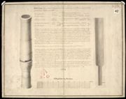
| Title: | Munsmeg, a Gun so called, at Edinburgh Castle; her Demensions, Requisite of Powder, Weight of Shott, greatest Range, Force etc., areas follow | |
| Name: | Borthwick, Robert (Engineer) | |
| Survey: | 1734 | |
| Shelfmark: | MS.1645 Z.02/11 | |
| Title: | A Plan of Fort Augustus with the Old Barracks and Situation 1734 [copy] | |
| Name: | Hewitt, John (Copyist) | |
| Survey: | 1734 | |
| Shelfmark: | MS.1647 Z.02/61b | |
| Title: | A Plan of part of Edinburgh Castle | |
| Name: | White, [John] (Engineer) | |
| Survey: | [1735] | |
| Shelfmark: | MS.1645 Z.02/09 | |
| Title: | A Plan of the Country where the New Intended Road is to be made from the Barrack at Ruthven in Badenoth to Invercall in Brae Marr… | |
| Name: | Avery, Joseph (Engineer) [Wade, George (Engineer)] | |
| Survey: | 1735 | |
| Shelfmark: | Acc.10497 Wade.58b | |
| Title: | [Plan showing fortifications of Fort William and Town of Maryborough.] | |
| Name: | [Wade, George (Engineer)] | |
| Survey: | [ca. 1736?] | |
| Shelfmark: | Acc.10497 Wade.58o | |
| Title: | A Plan of Fort William in the Shire of Inverness, with the District as is described by the Occult lines markt with yel=low & bounded by the River Navis. | |
| Name: | [Wade, George (Engineer)] | |
| Survey: | 1736 | |
| Shelfmark: | Acc.10497 Wade.58p | |
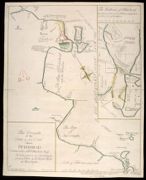
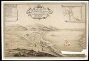
| Title: | This Draught of the Town & Sea Coast About Peterhead Commonly call'd Buchan-Ness Is dedicated to the Inhabitants of said Town by William Moir of Invernytie | |
| Name: | Moir, William Jaffray, John (Draughtsman) | |
| Survey: | 1739 | |
| Shelfmark: | MS.1648 Z.03/29b | |
| Title: | Elevations and Section for a Governours, Storekeeper, and Master Gunner's House at Edinborough Castle for the year 1740 [copy] | |
| Name: | Campbell, Dugal (Engineer) Deleny, John (Copyist) | |
| Survey: | 1740 | |
| Shelfmark: | MS.1645 Z.02/05a | |
| Title: | A Map of the Roads between Innersnaid Ruthvan of Badenock, Kiliwhiman and Fort William, in the Highlands of North Brittain [1718] 1741[copy] | |
| Name: | Dumaresq, John & Bastide, John Henri (Engineer) Bastide, John Henri (Draughtsman) Coombs, Richard (Copyist) | |
| Survey: | 1741 | |
| Shelfmark: | MS.1648 Z.03/14a | |
| Title: | A Map of the Roads between Innersnait, Ruthvan of Badenock, Kiliwhiman and Fort William, in the Highlands of North Brittain [1718] 1741[copy] | |
| Name: | Dumaresq, John & Bastide, John Henri (Engineer) Bastide, John Henri (Draughtsman) Assiotti, Francis Aegidius (Copyist) | |
| Survey: | 1741 | |
| Shelfmark: | MS.1648 Z.03/14b | |
| Title: | A Map of the Roads between Innersnaid Ruthvan of Badenock, Kiliwhiman and Fort William in the Highlands of North Brittain [1718] 1741 [copy] | |
| Name: | Dumaresq, John & Bastide, John Henri (Engineer) Bastide, John Henri (Draughtsman) | |
| Survey: | 1741 | |
| Shelfmark: | MS.1648 Z.03/14c | |
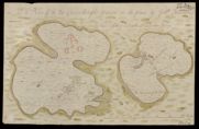
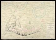
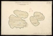
| Title: | A Plan of the Island of Mull with the adjacent Islands Drawen on the place | |
| Name: | Johnson, Robert (Overseer) | |
| Survey: | [1741] | |
| Shelfmark: | MS.1648 Z.03/23a | |
| Title: | A Plan of the Island of Mull with the adjacent Islands [copied] 1741 | |
| Name: | Johnson, Robert (Overseer) | |
| Survey: | 1741 | |
| Shelfmark: | MS.1648 Z.03/23b | |
| Title: | A Plan of the Two Carrinburghs 1741 [copy] | |
| Name: | Johnson, Robert (Overseer) | |
| Survey: | 1741 | |
| Shelfmark: | MS.1648 Z.03/24b | |
| Title: | Plan of the Castle of Blackness [ca.1690] | |
| Name: | Dury, Theodore (Engineer) | |
| Survey: | [1741] | |
| Shelfmark: | MS.1647 Z.02/75a | |
| Title: | Plan of the Castle of Blackness [in 1690]; [copied in] 1741 | |
| Name: | Dury, Theodore (Engineer) | |
| Survey: | [1741] | |
| Shelfmark: | MS.1647 Z.02/75b | |
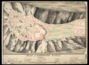
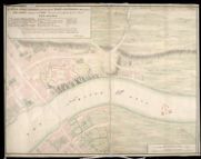
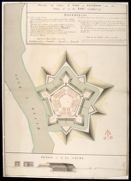
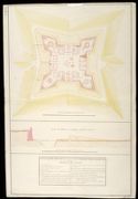
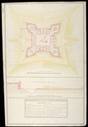
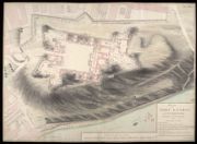
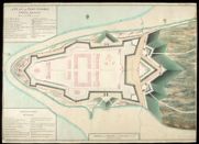
| Title: | The Plan of Fort Augustus, in the Highlands of Scotland (a modern fortification, Copied from the delineation of Captn John Romer, Engineer). This fortification was begun in 1729, & finish'd in 1742. | |
| Name: | Romer, John Lambertus (Engineer) | |
| Survey: | ca.1742? | |
| Shelfmark: | MS.1647 Z.02/63 | |
| Title: | A Draught of Innersnait, in the Highlands of North Brittain, nere the Head of Loch Lomend with part of the country adjacent [copy] | |
| Name: | Dumaresq, John & Bastide, John Henri (Engineer) Bastide, John Henri (Draughtsman) | |
| Survey: | 1742 | |
| Shelfmark: | MS.1648 Z.03/15c | |
| Title: | Plan of the Works on the Entrance of the Castle of Edinbo.[1742] [copy] | |
| Name: | Campbell, Dugal (Engineer) Anderson, Jabez (Copyist) | |
| Survey: | pre-1742 | |
| Shelfmark: | MS.1645 Z.02/04b | |
| Title: | Plan of the Works on the Entrance of the Castle of Edinb. [1742] [copy] | |
| Name: | Campbell, Dugal (Engineer) Sedley, John S. (Copyist) | |
| Survey: | pre-1742 | |
| Shelfmark: | MS.1645 Z.02/04c | |
| Title: | A Plan of Edinburgh Castle [1737] [copy] | |
| Name: | Romer, John Lambertus (Engineer) | |
| Survey: | pre-1742 | |
| Shelfmark: | MS.1645 Z.02/04d | |
| Title: | Plan of the Front on the Entrance to Fort William, representing the Main Gate Way as proposed to be rebuilt with the Wing Walls sustaining the ground of the Rampart on each side of the Entrance. And the manner proposed for forming the Earth Work of the R | |
| Name: | Campbell, Dugal (Engineer) Deleny, John (Copyist) | |
| Survey: | [1744] | |
| Shelfmark: | MS.1646 Z.02/27a | |
| Title: | Plan of the front on the Entrance to Fort William, representing the Main Gate Way as proposed to be rebuilt with the Wing Walls sustaining the ground of the Rampart on each side of the Entrance. And the manner proposed for forming the Earth Work of the R | |
| Name: | Campbell, Dugal (Engineer) Field, John (Copyist) | |
| Survey: | [1744] | |
| Shelfmark: | MS.1646 Z.02/27b | |
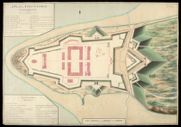
| Title: | Plan of Fort William 1745 | |
| Name: | Campbell, Dugal (Engineer) Tarrant, Charles (Copyist) | |
| Survey: | 1745 | |
| Shelfmark: | MS.1646 Z.02/29a | |
| Title: | Plan of Fort William 1745 [copy] | |
| Name: | Campbell, Dugal (Engineer) Deleny, John (Copyist) | |
| Survey: | 1745 | |
| Shelfmark: | MS.1646 Z.02/29b | |
| Title: | Plan of Fort William 1745 [copy] | |
| Name: | Campbell, Dugal (Engineer) Deleny, John (Copyist) | |
| Survey: | 1745 | |
| Shelfmark: | MS.1646 Z.02/29c | |
| Title: | A plan of the action at Seatowne the 21. of Septr. 1745 by an engineer ... who was present ... / (P. Fourdrinier sulp.) [By Richard Jack?] | |
| Name: | Fourdrinier, Paul | |
| Survey: | 1745 | |
| Shelfmark: | EMS.s.162 | |
| Title: | A Map of the River Forth, from Stirling to Barroustouness, including Linlithgow, Falkirk, and the countries adjacent, with the route of both armies to the field of battle. / T. Jefferys sculp.. | |
| Name: | Jefferys, Thomas | |
| Survey: | 1746 | |
| Shelfmark: | EMS.s.161 | |
| Title: | A plan of the battle of Culloden and the adjacent country, shewing the Incampment of the English Army at Nairn and the March of the Highlanders in order to attack them by night | |
| Name: | Finlayson, John ? | |
| Survey: | 1746? | |
| Shelfmark: | EMS.s.156 | |
| Title: | A Map of the River Forth, from Stirling to Barroustouness, including Linlithgow, Falkirk, and the countries adjacent, with the route of both armies to the field of battle. / T. Jefferys sculp.. | |
| Name: | Jefferys, Thomas | |
| Survey: | 1746 | |
| Shelfmark: | EMS.s.794 | |
| Title: | Plan, Elevation and Sections of a Shed, Ordered to be built at Edinbo. Castle for the reception of 50 Bread Carts. [1746] [copy] | |
| Name: | Campbell, Dugal (Engineer) Spencer, John (Copyist) | |
| Survey: | 1746 | |
| Shelfmark: | MS.1645 Z.02/06b | |

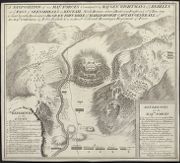
| Title: | A Plan of the Batle of Coullodin moore fought on the 16th. Of Aprile 1746 | |
| Name: | Paterson, Daniel (Engineer) | |
| Survey: | 1746 | |
| Shelfmark: | MS.1648 Z.03/30a | |
| Title: | A Plan of ye Battle of Colloden between his Majs. Forces Under the Command of his Royall Highness the Duke of Cumberland and the Sctt. Rebels April ye 16 1746 | |
| Name: | Jones, Jasper Leigh (Draughtsman) | |
| Survey: | 1746 | |
| Shelfmark: | MS.1648 Z.03/30b | |
| Title: | Profils of the Proposed Additional Works at Fort Augustus [1746] [copy]; Profile of the Fort through the Courtine; Profile of the Ravelin; Profile of the Covered Way and Glacies; Profil through the Line A.B in the Plan; Profile of the Entrenchment before | |
| Name: | Marcell, Lewis (Engineer) Read, William (Copyist) | |
| Survey: | 1746 | |
| Shelfmark: | MS.1647 Z.02/64c | |
| Title: | Plan for building a Fort at Inverness on the Vestige of an old Fort demolished 1746 [copy] | |
| Name: | Skinner, William (Engineer) Tarrant, Charles (Draughtsman) Thomas Smart (Copyist) | |
| Survey: | 1746 | |
| Shelfmark: | MS.1647 Z.02/82a | |
| Title: | A Plan of an Ancient piece of Fortification Near Perth Lately Repair'd by the Rebels | |
| Name: | Jones, Jasper Leigh (Draughtsman) | |
| Survey: | 1746 | |
| Shelfmark: | MS.1647 Z.03/01c | |
| Title: | A Plan of Fort Augustus in its present State with a Designd Fossee & Cover'd Way 1747 [copy] | |
| Name: | Skinner, William (Engineer) Miller, James (Copyist) | |
| Survey: | 1747 | |
| Shelfmark: | MS.1647 Z.02/65b | |
| Title: | A Plan of Fort Augustus in its present State with a Designd Fossee & Cover'd Way 1747 [copy] | |
| Name: | Skinner, William (Engineer) Miller, James (Copyist) | |
| Survey: | 1747 | |
| Shelfmark: | MS.1647 Z.02/65c | |
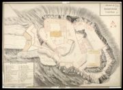
| Title: | Plan of Fort Augustus shewing the repairs and Additions done between Iune and September 1747. with the Works proposed to be Compleated in 1748 [copy] | |
| Name: | Skinner, William (Engineer) T.C. (Copyist) | |
| Survey: | 1747 | |
| Shelfmark: | MS.1647 Z.02/66c | |
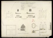
| Title: | An Exact Plan of a Part of Edinr. Castle, showing the Situation of the Powder Magazine &c. | |
| Name: | Watson, David (Engineer) | |
| Survey: | 1747 | |
| Shelfmark: | MS.1645 Z.02/07a | |
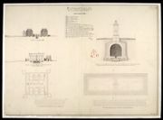
| Title: | Plan & Section of the Powder Magazine as it is at present, containing 684 Barrills of Powder. | |
| Name: | Watson, David (Engineer) | |
| Survey: | 1747 | |
| Shelfmark: | MS.1645 Z.02/07b | |
| Title: | Plan & Section of the Powder Magazine with the alterations propos'd, & will contain 1054 Barrils of Powder | |
| Name: | Watson, David (Engineer) | |
| Survey: | 1747 | |
| Shelfmark: | MS.1645 Z.02/07c | |
| Title: | Plan of the point of land at Arderseer with the design'd fort as trac'd thereon | |
| Name: | Skinner, William (Engineer) Heath, Joseph (Draughtsman) | |
| Survey: | [ca.1748-9?] | |
| Shelfmark: | MS.1647 Z.02/57a | |
| Title: | Plan of the point of land at Arderseer with the design'd fort as trac'd thereon [copy] | |
| Name: | Skinner, William (Engineer) Heath, Joseph (Draughtsman) | |
| Survey: | [ca.1748-9?] | |
| Shelfmark: | MS.1647 Z.02/57b | |
| Title: | Plan of the point of land at Arderseer with the design'd Fort as trac'd thereon [copy] | |
| Name: | Skinner, William (Engineer) Heath, Joseph (Draughtsman) | |
| Survey: | [ca.1748-9?] | |
| Shelfmark: | MS.1647 Z.02/57c | |
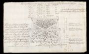
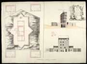
| Title: | Sketch of the ground about Braemarr Castle | |
| Name: | Watson, David (Engineer) | |
| Survey: | 1748 | |
| Shelfmark: | MS.1649 Z.03/32c | |
| Title: | Section of Braemarr Castle on the Line EF as it stands at present | |
| Name: | Watson, David (Engineer) | |
| Survey: | 1748 | |
| Shelfmark: | MS.1649 Z.03/33a | |
| Title: | Plan of Braemarr Castle as it stands at present. | |
| Name: | Watson, David (Engineer) | |
| Survey: | 1748 | |
| Shelfmark: | MS.1649 Z.03/33b | |
| Title: | Plan of Repairs for Braemarr Castle | |
| Name: | Watson, David (Engineer) | |
| Survey: | 1748 | |
| Shelfmark: | MS.1649 Z.03/33c | |
| Title: | Sketch of the Ground about Corgarff | |
| Name: | Watson, David (Engineer) | |
| Survey: | 1748 | |
| Shelfmark: | MS.1649 Z.03/35a | |
| Title: | Plan of the Ground Story of Corgarff Castle with the New Additions | |
| Name: | Watson, David (Engineer) | |
| Survey: | 1748 | |
| Shelfmark: | MS.1649 Z.03/37a | |
| Title: | Plan of Corgarff Castle as it stands at present. | |
| Name: | Watson, David (Engineer) | |
| Survey: | 1748 | |
| Shelfmark: | MS.1649 Z.03/37b | |
| Title: | Plan of the Repairs for Corgarff Castle | |
| Name: | Watson, David (Engineer) | |
| Survey: | 1748 | |
| Shelfmark: | MS.1649 Z.03/37c | |
| Title: | Plan of Castle Tyrim in Muydart; Plan of Castle Duirt in the Island of Mull 1748 [copy] | |
| Name: | Watson, David (Engineer) Sandby, Paul (Draughtsman) | |
| Survey: | 1748 | |
| Shelfmark: | MS.1648 Z.03/28d | |
| Title: | Plan of Castle Tyrim in Muydart; Plan of Castle Duirt in the Island of Mull 1748 | |
| Name: | Watson, David (Engineer) Sandby, Paul (Draughtsman) | |
| Survey: | 1748 | |
| Shelfmark: | MS.1648 Z.03/28e | |
| Title: | Report of Castle Tyrrim, Castle Duirt and the Castle in Island Stalker | |
| Name: | Watson, David (Engineer) | |
| Survey: | 1748 | |
| Shelfmark: | MS.1648 Z.03/28f | |
| Title: | Old Plans of Corgraff Castle; Repairs; Repairs of Braemarr Castle [copy] | |
| Name: | Coltman, Nathaniel (Copyist) | |
| Survey: | [1749] | |
| Shelfmark: | MS.1649 Z.03/37e | |
| Title: | A Survey of the Road made by the Detachmt. Of Genl. Guise's Regt. In Brae Marr; beginning where Genl. Blakeney's left off; & Continue'd to the Spittle of Glen-Shee 1749 | |
| Name: | Archer, John (Engineer) | |
| Survey: | 1749 | |
| Shelfmark: | MS.1649 Z.03/32a | |
| Title: | A Survey of the Road made by the Detachment. Of Genl. Guise's Regt. In Brae Marr; begining where Genl. Blakeney's left off; & Continued to the Spittle of Glen Shee 1749 [copy] | |
| Name: | Archer, John (Engineer) | |
| Survey: | 1749 | |
| Shelfmark: | MS.1649 Z.03/32b | |
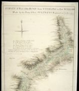
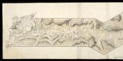
| Title: | Survey of Part of the Road from Sterling to Fort William; Made by the Party of Genl. Pultneys Regiment in 1749 | |
| Name: | Morrison, George (Engineer) | |
| Survey: | 1749 | |
| Shelfmark: | MS.1649 Z.03/39a | |
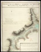
| Title: | Survey of Part of the Road from Sterling to Fort William; Made by the Party of Genl. Pultneys Regiment in 1749 [copy] | |
| Name: | Morrison, George (Engineer) | |
| Survey: | 1749 | |
| Shelfmark: | MS.1649 Z.03/39b | |
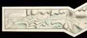
| Title: | Remarks on the Country Adjacent to part of the Road from Sterling to Fort William, made by the Party of Genl. Pultneys Regement, from part of Loch Lubinich to the beginning of Larigilay. Eight Miles and Forty five Yards | |
| Name: | Morrison, George (Engineer) | |
| Survey: | 1749 | |
| Shelfmark: | MS.1649 Z.03/39c | |

| Title: | A Survey of the Road made by the Detatchments Colln. Rich's & Genl. Guise's Regts. between Fort William & the head of King-loch Leven 1750 | |
| Name: | Archer, John (Engineer) | |
| Survey: | 1750 | |
| Shelfmark: | MS.1649 Z.03/40a | |
| Title: | Plans of Brae-Marr Castle in the Year 1750 [copy] | |
| Name: | Skinner, William (Engineer) Tarrant, Charles (Draughtsman) Day, Thomas (Copyist) | |
| Survey: | 1750 | |
| Shelfmark: | MS.1649 Z.03/31b | |
| Title: | Plans of Brae-Marr Castle in the Year 1750 [copy] | |
| Name: | Skinner, William (Engineer) Tarrant, Charles (Draughtsman) Burr, G.D. (Copyist) | |
| Survey: | 1750 | |
| Shelfmark: | MS.1649 Z.03/31c | |
| Title: | Survey of the different Parts of the Road joyned betwixt Blair Gowrie and Braemar; Made by a Detachment of one Hundred Men of Lord Viscount Bury's Regt. in the Year 1750 | |
| Name: | Morrison, George (Engineer) | |
| Survey: | 1750 | |
| Shelfmark: | MS.1649 Z.03/38a | |
| Title: | A Plan of Fort Augustus with the adjacent lands 1750 [copy] | |
| Name: | Daubant, Abraham (Engineer) Rogerson, William M. (Copyist) | |
| Survey: | 1750 | |
| Shelfmark: | MS.1647 Z.02/67c | |
| Title: | Plan of Fort George at Inverness, Shewing it's present Condition. 1750 [copy] | |
| Name: | Skinner, William (Engineer) Tarrant, Charles (Draughtsman) Burr, G.D. (Copyist) | |
| Survey: | 1750 | |
| Shelfmark: | MS.1646 Z.02/36b | |
| Title: | Plan of Fort George North Britain Shewing how far the Works are Carried on in 1750 and what is propos'd to be done in 1751 [copy] | |
| Name: | Skinner, William (Engineer) Tarrant, Charles (Draughtsman) Day, Thomas (Copyist) | |
| Survey: | 1750 | |
| Shelfmark: | MS.1646 Z.02/40b | |
| Title: | Plan of Edinburgh Castle, 1750 [copy] | |
| Name: | Skinner, William (Engineer) Fane, Stephen (Draughtsman) Day, Thomas (Copyist) | |
| Survey: | 1750 | |
| Shelfmark: | MS.1645 Z.02/08b | |
| Title: | Plan, Elevation and Section of the South Bastion of Fort William, Shewing the Breach occasiond by the Shooting of Part of the Scarp-Wall. | |
| Name: | Walker, Thomas (Engineer) | |
| Survey: | 1751 | |
| Shelfmark: | MS.1646 Z.02/31a | |
| Title: | Plan, Elevation and Section of the South Bastion of Fort William, Shewing the Breach occasion'd by the Shooting of Part of the Scarp Wall [copy] | |
| Name: | Walker, Thomas (Engineer) Gould, Francis (Draughtsman) | |
| Survey: | [1751] | |
| Shelfmark: | MS.1646 Z.02/31b | |

| Title: | Plans Section and Elevation of the Barrack at Cargarff [about 1750] [copy] | |
| Name: | Skinner, William (Engineer) Tarrant, Charles (Draughtsman) Day, Thomas (Copyist) | |
| Survey: | 1752 | |
| Shelfmark: | MS.1649 Z.03/35d | |
| Title: | Plan and Section of the Pier built at Fort Augustus in 1753 [copy] | |
| Name: | Skinner, William (Engineer) Read, William (Copyist) | |
| Survey: | 1753 | |
| Shelfmark: | MS.1647 Z.02/68b | |
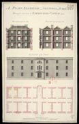
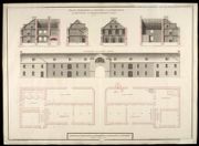
| Title: | A Plan, Elevation and Sections of the Barracks Design'd to be built in Edinburgh Castle 1755 | |
| Name: | Tarrant, Charles (Draughtsman) Rae, Alfred (Copyist) | |
| Survey: | 1755 | |
| Shelfmark: | MS.1646 Z.02/15 | |

| Title: | A Prospect of that Part of the Land and Sea adjacent to the Barrack to be Built in Glen Elg [1720] [copy] | |
| Name: | Bastide, John Henri (Engineer) Test, William (Copyist) | |
| Survey: | 1762 | |
| Shelfmark: | MS.1647 Z.03/07b | |
| Title: | A Prospect of that Part of the Land and Sea adjacent to the Barrack to be Built in Glen Elg [1720] [copy] | |
| Name: | Bastide, John Henri (Engineer) [Test, William (Copyist)] | |
| Survey: | 1762 | |
| Shelfmark: | MS.1647 Z.03/07c | |
| Title: | Barnera [1719] [copy] | |
| Name: | Bastide, John Henri (Engineer) Gould, Francis (Copyist) | |
| Survey: | 1763 | |
| Shelfmark: | MS.1647 Z.03/05b | |
| Title: | Plan Elevation and Sections of the Store-House for Provisions, and Barrack-Masters Stores 1762 [copy] | |
| Name: | Skinner, William (Engineer) Booth, William (Draughtsman) | |
| Survey: | 1764 | |
| Shelfmark: | MS.1647 Z.02/55b | |
| Title: | Plan Section and Elevation of the barracks at Killiwhimen, with a particular plan and section of the cistern [1723] [copy] | |
| Name: | Romer, John Lambertus (Engineer) | |
| Survey: | 1766 | |
| Shelfmark: | MS.1647 Z.03/12b | |
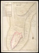
| Title: | Plan of the Kings House and Garden at Perth [1723] [copy] | |
| Name: | Romer, John Lambertus (Engineer) Cooper, John (Copyist) | |
| Survey: | 1773 | |
| Shelfmark: | MS.1647 Z.03/03b | |
| Title: | Survey of the different parts of the Road joyned betwixt Blair Gowrie and Brae Mar; Made by a Detachment of one Hundred Men of Lord Viscount Bury's Regt. in the Year 1750 [copy] | |
| Name: | Morrison, George (Engineer) Castleman, Henry (Copyist) | |
| Survey: | 1779 | |
| Shelfmark: | MS.1649 Z.03/38b | |
| Title: | Survey of the different parts of the Road joyned betwixt Blair Gowrie and Brae Mar; Made by a Detachment of one Hundred Men of Lord Viscount Bury's Regt. in the Year 1750 [copy] | |
| Name: | Morrison, George (Engineer) Gould, Francis (Draughtsman) | |
| Survey: | 1781 | |
| Shelfmark: | MS.1649 Z.03/38c | |
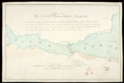
| Title: | Plan of the River or Firth of Forth | |
| Name: | Colebrooke, Pawlett William (Engineer) | |
| Survey: | 1782 | |
| Shelfmark: | MS.1649 Z.03/47a | |
| Title: | Plan of the River or Firth of Forth [1782] [copy] | |
| Name: | Colebrooke, Pawlett William (Engineer) | |
| Survey: | 1782 | |
| Shelfmark: | MS.1649 Z.03/47b | |
| Title: | Plan of the Bay called Brassa Sound [1783] [copy] | |
| Name: | Frazer, Andrew (Engineer) Dodd, Pressick (Copyist) | |
| Survey: | 1786 | |
| Shelfmark: | MS.1649 Z.03/43b | |
| Title: | Sketch of the Ground about Cargarff [1748] [copy] | |
| Name: | Watson, David (Engineer) Dodd, Pressick (Copyist) | |
| Survey: | 1786 | |
| Shelfmark: | MS.1649 Z.03/35b | |
| Title: | Plans and Elevations of the Barracks at Fort Charlotte Shetland [1786] [copy] | |
| Name: | Frazer, Andrew (Engineer) Dodd, Pressick (Copyist) | |
| Survey: | 1787 | |
| Shelfmark: | MS.1649 Z.03/44c | |
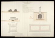
| Title: | Sketch of the Carpenters Work in Ten Feet Running of the Pier at Fort George | |
| Name: | Shipley, Sir Charles (Engineer) Elphinstone, Sir Howard (Engineer) | |
| Survey: | 1787 | |
| Shelfmark: | MS.1650 Z.46/57f | |
| Title: | Plan, Section and Elevation of the Barrack at Inveersnait and Kiliwhiman [with] Explanation; Powder Magasine at Edinbgh. Castle and Section of the Same at x; with a project of Arching the second Floor at y [1720] [copy] | |
| Name: | Romer, John Lambertus (Engineer) Chamberlaine, Thomas (Draughtsman) | |
| Survey: | 1798 | |
| Shelfmark: | MS.1647 Z.03/11b | |
| Title: | Fort George in North Britain 1769 | |
| Name: | Skinner, William (Engineer) Sedley, John S. (Copyist) | |
| Survey: | [1769] | |
| Shelfmark: | MS.1647 Z.02/59b | |
| Title: | A Plan of Fort George North Britain [1769] | |
| Name: | Skinner, William (Engineer) Robinson, David, & Basset, C. (Copyist) | |
| Survey: | [1769] | |
| Shelfmark: | MS.1647 Z.02/59c | |
| Title: | Plan of Train Barracks at Perth Formerly the House of Earl Gowry [1754] [copy] | |
| Name: | Tarrant, Charles (Draughtsman) Rae, Alfred (Copyist) | |
| Survey: | 1808 | |
| Shelfmark: | MS.1647 Z.03/04b | |
| Title: | A Plan of Fort George North Britain [1769] | |
| Name: | Skinner, William (Engineer) Rogerson, William M. (Copyist) | |
| Survey: | [1769?] | |
| Shelfmark: | MS.1647 Z.02/59a | |
| Title: | Plans Section and Elevation of the Barrack at Cargarff [about 1750] [copy] | |
| Name: | Skinner, William (Engineer) Tarrant, Charles (Draughtsman) Rae, Alfred (Copyist) | |
| Survey: | 1808 | |
| Shelfmark: | MS.1649 Z.03/35e | |
| Title: | Plan of Fort Charlotte at Lerwick in Shetland No. 2 Jany. 1783 [copy] | |
| Name: | Frazer, Andrew (Engineer) Lewis, W. (Copyist) | |
| Survey: | 1812 | |
| Shelfmark: | MS.1649 Z.03/42c | |
| Title: | Plan of Brassa Sound in the Southern Part of the Isles of Shetland, and Survey of the Grounds adjoining to Fort Charlotte [1783] [copy] | |
| Name: | Frazer, Andrew (Engineer) Fisher, T. (Copyist) | |
| Survey: | 1812 | |
| Shelfmark: | MS.1649 Z.03/43c | |
| Title: | Plan of Fort Charlotte in March 1781 No. 1; Section from A to B in March 1781; Section from A to B January 1783 [copy] | |
| Name: | Frazer, Andrew (Engineer) Field, John (Copyist) | |
| Survey: | 1812 | |
| Shelfmark: | MS.1649 Z.03/48b | |
| Title: | Plan of Fort Charlotte in March 1781 No. 1; Section from A to B in March 1781; Section from A to B January 1783 [copy] | |
| Name: | Frazer, Andrew (Engineer) Field, John (Copyist) | |
| Survey: | 1812 | |
| Shelfmark: | MS.1649 Z.03/48c | |
| Title: | Sketch of the River Clyde shewing the proposed situation for a Battery of nine 26 Prs. for the defence of the Harbour and Anchorage at Greenock; Plan of White Farline Point with the proposed Battery of nine 26 Prs. having a Magazine; Store House & Guard H | |
| Name: | [Carmichael-]Smyth, Major [J] (Engineer) | |
| Survey: | 1813 | |
| Shelfmark: | MS.1650 Z.46/19 | |
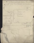
| Title: | [Map of area around Fort William showing] Boundary of the Crown lands; plans, elevations and sections of Ordnance Store and Magazine; Table of Reference [showing] Nature of the Encroachment, How Occupied, Occupiers Name, and Rent & to Whom Paid | |
| Name: | Elphinstone, Sir Howard (Engineer) | |
| Survey: | 1818 | |
| Shelfmark: | MS.1650 Z.46/21 | |
| Title: | Fort William; plan shewing the situation and extent of the grant made to the Episcopal Inhabitants by the Board in Decr. 1815 | |
| Name: | Elphinstone, Sir Howard (Engineer) | |
| Survey: | 1818 | |
| Shelfmark: | MS.1650 Z.46/22 | |
| Title: | Edinburgh Castle - from Princes Street | |
| Name: | Blanc, Hippolyte (1844-1917) | |
| Survey: | ca. 1885-92 | |
| Shelfmark: | MS.1739, 18 | |
| Title: | Edinburgh Castle - | |
| Name: | Blanc, Hippolyte (1844-1917) | |
| Survey: | 1885 | |
| Shelfmark: | MS.1739, 19 | |
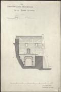
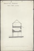
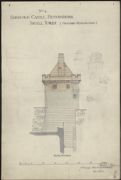
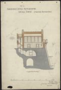
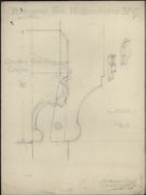
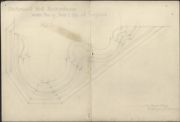
| Title: | Edinburgh Castle - Restorations Argyll Tower (as existing) No 1 | |
| Name: | Blanc, Hippolyte (1844-1917) | |
| Survey: | 1885 | |
| Shelfmark: | MS.1739, 22 | |
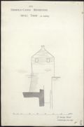
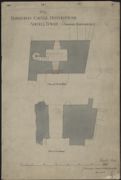
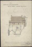
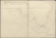
| Title: | Edinburgh Castle - Restorations Argyll Tower Previous to Restorations No 2 | |
| Name: | Blanc, Hippolyte (1844-1917) | |
| Survey: | 1885 | |
| Shelfmark: | MS.1739, 23 | |
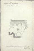
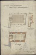
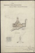
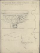
| Title: | Edinburgh Castle - Restorations Argyll Tower (as existing) No 3 | |
| Name: | Blanc, Hippolyte (1844-1917) | |
| Survey: | 1885 | |
| Shelfmark: | MS.1739, 24 | |
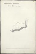
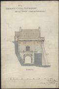
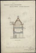
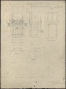
| Title: | Edinburgh Castle - Restorations Argyll Tower (as existing) No 4 | |
| Name: | Blanc, Hippolyte (1844-1917) | |
| Survey: | 1885 | |
| Shelfmark: | MS.1739, 25 | |
| Title: | Edinburgh Castle - Restorations Argyll Tower (as existing) No 5 | |
| Name: | Blanc, Hippolyte (1844-1917) | |
| Survey: | 1885 | |
| Shelfmark: | MS.1739, 26 | |
| Title: | Edinburgh Castle - Restorations Argyll Tower (as existing) No 6 | |
| Name: | Blanc, Hippolyte (1844-1917) | |
| Survey: | ca. 1885-92 | |
| Shelfmark: | MS.1739, 27 | |
| Title: | Edinburgh Castle - Restorations Argyll Tower (as existing) No 7 | |
| Name: | Blanc, Hippolyte (1844-1917) | |
| Survey: | ca. 1885-92 | |
| Shelfmark: | MS.1739, 28 | |
| Title: | Edinburgh Castle - Restorations Argyll Tower (proposed restorations) No 1 | |
| Name: | Blanc, Hippolyte (1844-1917) | |
| Survey: | 1885 | |
| Shelfmark: | MS.1739, 29 | |
| Title: | Edinburgh Castle - Restorations Argyll Tower (proposed restorations) No 2 | |
| Name: | Blanc, Hippolyte (1844-1917) | |
| Survey: | 1885 | |
| Shelfmark: | MS.1739, 30 | |
| Title: | Edinburgh Castle - Restorations Argyll Tower (proposed restorations) No 3 | |
| Name: | Blanc, Hippolyte (1844-1917) | |
| Survey: | 1885 | |
| Shelfmark: | MS.1739, 31 | |
| Title: | Edinburgh Castle - Restorations Argyll Tower (proposed restorations) No 4 | |
| Name: | Blanc, Hippolyte (1844-1917) | |
| Survey: | 1885 | |
| Shelfmark: | MS.1739, 32 | |
| Title: | Edinburgh Castle - Restorations Argyll Tower (proposed restorations) No 5 | |
| Name: | Blanc, Hippolyte (1844-1917) | |
| Survey: | 1885 | |
| Shelfmark: | MS.1739, 33 | |
| Title: | Edinburgh Castle - Restorations Argyll Tower (proposed restorations) No 6 | |
| Name: | Blanc, Hippolyte (1844-1917) | |
| Survey: | 1885 | |
| Shelfmark: | MS.1739, 34 | |
| Title: | Edinburgh Castle - Restorations Argyll Tower (proposed restorations) No 7 | |
| Name: | Blanc, Hippolyte (1844-1917) | |
| Survey: | 1885 | |
| Shelfmark: | MS.1739, 35 | |
| Title: | Edinburgh Castle - Restorations Argyll Tower (proposed restorations) No 8 | |
| Name: | Blanc, Hippolyte (1844-1917) | |
| Survey: | 1885 | |
| Shelfmark: | MS.1739, 36 | |
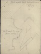
| Title: | Edinburgh Castle - Parliament Hall Restorations Moulded Wall-head Course | |
| Name: | Blanc, Hippolyte (1844-1917) | |
| Survey: | ca. 1885-92 | |
| Shelfmark: | MS.1739, 63 | |
| Title: | Edinburgh Castle - Parliament Hall Restorations Wallhead Course (Revised Drawing) | |
| Name: | Blanc, Hippolyte (1844-1917) | |
| Survey: | ca. 1885-92 | |
| Shelfmark: | MS.1739, 64 | |
| Title: | Edinburgh Castle - Parliament Hall Restorations Side Exterior Elevation Section Interior Elevation Plan | |
| Name: | Blanc, Hippolyte (1844-1917) | |
| Survey: | 1887 | |
| Shelfmark: | MS.1739, 66 | |
| Title: | Edinburgh Castle - Parliament Hall Restorations Drawings for Gallery & Stair at West End of Hall | |
| Name: | Blanc, Hippolyte (1844-1917) | |
| Survey: | ca. 1885-92 | |
| Shelfmark: | MS.1739, 69 | |
| Title: | Edinburgh Castle - Parliament Hall Restorations Drawing for Gallery at West End of Hall | |
| Name: | Blanc, Hippolyte (1844-1917) | |
| Survey: | ca. 1885-92 | |
| Shelfmark: | MS.1739, 70 | |
| Title: | Edinburgh Castle - Parliament Hall Restorations Drawing of Panelling on East Wall | |
| Name: | Blanc, Hippolyte (1844-1917) | |
| Survey: | ca. 1885-92 | |
| Shelfmark: | MS.1739, 76 | |
| Title: | Edinburgh Castle - Parliament Hall Restorations Ironmongery for Shutters | |
| Name: | Blanc, Hippolyte (1844-1917) | |
| Survey: | 1885 | |
| Shelfmark: | MS.1739, 72 | |
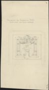
| Title: | Edinburgh Castle - Parliament Hall Restorations Central Panel over Royal Entrance | |
| Name: | Blanc, Hippolyte (1844-1917) | |
| Survey: | ca. 1885-92 | |
| Shelfmark: | MS.1739, 73 | |
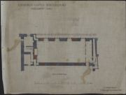
| Title: | Edinburgh Castle - Restorations Parliament Hall Plan of Hall Floor | |
| Name: | Blanc, Hippolyte (1844-1917) | |
| Survey: | 1887 | |
| Shelfmark: | MS.1739, 48 | |
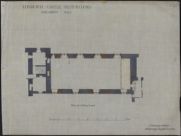
| Title: | Edinburgh Castle - Restorations Parliament Hall Plan at Gallery Level | |
| Name: | Blanc, Hippolyte (1844-1917) | |
| Survey: | 1887 | |
| Shelfmark: | MS.1739, 49 | |
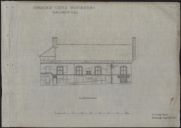
| Title: | Edinburgh Castle - Restorations Parliament Hall North Elevation | |
| Name: | Blanc, Hippolyte (1844-1917) | |
| Survey: | 1887 | |
| Shelfmark: | MS.1739, 50 | |
| Title: | Edinburgh Castle - Restorations Parliament Hall South Elevation | |
| Name: | Blanc, Hippolyte (1844-1917) | |
| Survey: | 1887 | |
| Shelfmark: | MS.1739, 51 | |
| Title: | Edinburgh Castle - Restorations Parliament Hall Longitudinal Section | |
| Name: | Blanc, Hippolyte (1844-1917) | |
| Survey: | 1887 | |
| Shelfmark: | MS.1739, 52 | |
| Title: | Edinburgh Castle - Restorations Parliament Hall Cross Section Looking East | |
| Name: | Blanc, Hippolyte (1844-1917) | |
| Survey: | 1887 | |
| Shelfmark: | MS.1739, 53 | |
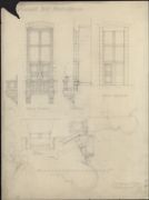
| Title: | Edinburgh Castle - Parliament Hall Restorations Drawing of Window on North Side | |
| Name: | Blanc, Hippolyte (1844-1917) | |
| Survey: | 1887 | |
| Shelfmark: | MS.1739, 54 | |
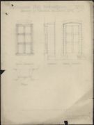
| Title: | Edinburgh Castle - Parliament Hall Restorations Drawing of Window on South Side | |
| Name: | Blanc, Hippolyte (1844-1917) | |
| Survey: | 1887 | |
| Shelfmark: | MS.1739, 55 | |
| Title: | Edinburgh Castle - Parliament Hall Restorations Full Size Details of Windows | |
| Name: | Blanc, Hippolyte (1844-1917) | |
| Survey: | 1887 | |
| Shelfmark: | MS.1739, 56 | |
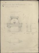
| Title: | Edinburgh Castle - Parliament Hall Restorations Drawing for Fireplace in Hall | |
| Name: | Blanc, Hippolyte (1844-1917) | |
| Survey: | 1887 | |
| Shelfmark: | MS.1739, 57 | |
| Title: | Edinburgh Castle - Parliament Hall Restorations Details of Fireplace Cap and Jamb | |
| Name: | Blanc, Hippolyte (1844-1917) | |
| Survey: | 1887 | |
| Shelfmark: | MS.1739, 58 | |
| Title: | Edinburgh Castle - Parliament Hall Restorations Inverted Plan of Jamb & Cap. Of Fireplace | |
| Name: | Blanc, Hippolyte (1844-1917) | |
| Survey: | 1887 | |
| Shelfmark: | MS.1739, 59 | |
| Title: | Edinburgh Castle - Parliament Hall Restorations Inverted Plan of Jamb & Base Of Fireplace | |
| Name: | Blanc, Hippolyte (1844-1917) | |
| Survey: | 1887 | |
| Shelfmark: | MS.1739, 59 | |
| Title: | Edinburgh Castle - Parliament Hall Restorations Details for the Upper Part of Fireplace | |
| Name: | Blanc, Hippolyte (1844-1917) | |
| Survey: | 1887 | |
| Shelfmark: | MS.1739, 60 | |
| Title: | Edinburgh Castle - Parliament Hall Restorations Drawing for Entrance Door | |
| Name: | Blanc, Hippolyte (1844-1917) | |
| Survey: | 1887 | |
| Shelfmark: | MS.1739, 61 | |
| Title: | Edinburgh Castle - Parliament Hall Restorations Drawing for Wallhead | |
| Name: | Blanc, Hippolyte (1844-1917) | |
| Survey: | 1887 | |
| Shelfmark: | MS.1739, 62 | |

| Title: | Edinburgh Castle - Restorations Parliament Hall Cross Section Looking West | |
| Name: | Blanc, Hippolyte (1844-1917) | |
| Survey: | 1888 | |
| Shelfmark: | MS.1739, 67 | |
| Title: | Edinburgh Castle - Parliament Hall Restorations Plan of First Floor | |
| Name: | Blanc, Hippolyte (1844-1917) | |
| Survey: | 1888 | |
| Shelfmark: | MS.1739, 68 | |
| Title: | Edinburgh Castle - Parliament Hall Restorations Drawing shewing New Parapet on North Elevation | |
| Name: | Blanc, Hippolyte (1844-1917) | |
| Survey: | 1888 | |
| Shelfmark: | MS.1739, 65 | |
| Title: | Edinburgh Castle - Parliament Hall Restorations 1/2 Detail of Panelling at East End of Hall | |
| Name: | Blanc, Hippolyte (1844-1917) | |
| Survey: | 1890 | |
| Shelfmark: | MS.1739, 71 | |
| Title: | Edinburgh Castle - Parliament Hall Restorations One panel over South East Door Three panels over North East Door | |
| Name: | Blanc, Hippolyte (1844-1917) | |
| Survey: | 1890 | |
| Shelfmark: | MS.1739, 74 | |
| Title: | Edinburgh Castle - Parliament Hall Restorations F B Gracery (?) panels on side panelling near East End | |
| Name: | Blanc, Hippolyte (1844-1917) | |
| Survey: | 1890 | |
| Shelfmark: | MS.1739, 75 | |
| Title: | Edinburgh Castle - Parliament Hall Restorations Detail of Presentation key | |
| Name: | Blanc, Hippolyte (1844-1917) | |
| Survey: | 1892 | |
| Shelfmark: | MS.1739, 77 | |
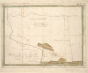
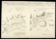
| Title: | General Wade's plan for a Glenfeshie road. | |
| Name: | Avery, Joseph / Mathieson, John | |
| Survey: | 1923 | |
| Shelfmark: | EMS.b.2.174(24) | |
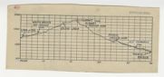
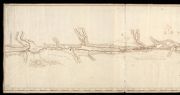
| Title: | [Profile of the proposed route of Wade's road from Linn of Dee via Geldie Lodge and Glen Feshie to Tromie Bridge] | |
| Name: | Avery, Joseph / Mathieson, John | |
| Survey: | 1923 | |
| Shelfmark: | EMS.b.2.174(24) | |