Military Maps of Scotland (18th century)
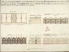
| Title: | Plan, Elevation and Sections of additional Barracks of Timber, Ordered by his Royal Highness the Duke of Cumberland to be built at Fort William, on the vacant ground near the Governours House for the accomodateing 160 private Men [copy] |
| Name: | Campbell, Dugal (Engineer) |
| Description: | 1 manuscript map ; 449 x 594 mm., on sheet, 457 x 603 mm. |
| Original Survey: | 1746 |
| Date on Map: | 1746? |
| Placename: | Fort William |
| Parish: | Kilmallie |
| County: | Inverness-shire |
| Shelfmark: | MS.1646 Z.02/30b |
| Zoom Into Map: | Click on the map to view in greater detail. |
All images © Crown Copyright and © National Library of Scotland