Military Maps of Scotland (18th century)
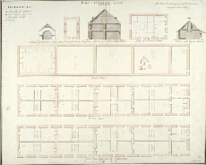
| Title: | Fort William, Anno 1719 [No.1] [copy] |
| Name: | Jelfe, Andrews (Architect) Moore, Thomas (Engineer) Dodd, Pressick (Copyist) |
| Description: | 1 manuscript map ; 464 x 583 mm., on sheet, 491 x 609 mm. |
| Original Survey: | 1719 |
| Date on Map: | 1785 |
| Placename: | Fort William |
| Parish: | Kilmallie |
| County: | Inverness-shire |
| Shelfmark: | MS.1646 Z.02/26b |
| Zoom Into Map: | Click on the map to view in greater detail. |
All images © Crown Copyright and © National Library of Scotland