Military Maps of Scotland (18th century)
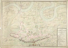
| Title: | Plan of the Town and Castle of Sterling 1740 |
| Description: | 1 manuscript map ; 482 x 695 mm., on sheet, 548 x 761 mm. |
| Original Survey: | [1725] |
| Date on Map: | 1725. (Shows Thedore Dury's outer defensive works at the southern end of the castle, constructed from 1708-1714). |
| Placename: | Stirling |
| Parish: | Stirling |
| County: | Stirlingshire |
| Shelfmark: | MS.1646 Z.02/21a |
| Zoom Into Map: | Click on the map to view in greater detail. |
All images © Crown Copyright and © National Library of Scotland