Military Maps of Scotland (18th century)
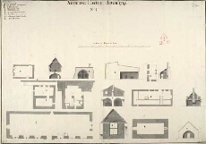
| Title: | Sterling Castle, Novembr: 1719, No.4 |
| Name: | Jelfe, Andrews (Architect) Moore, Thomas (Engineer) |
| Description: | 1 manuscript map ; 495 x 711 mm., on sheet, 506 x 722 mm. |
| Original Survey: | 1719 |
| Date on Map: | 1719 |
| Placename: | Stirling |
| Parish: | Stirling |
| County: | Stirlingshire |
| Shelfmark: | MS.1646 Z.02/18d |
| Zoom Into Map: | Click on the map to view in greater detail. |
All images © Crown Copyright and © National Library of Scotland