Military Maps of Scotland (18th century)
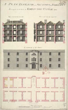
| Title: | A Plan, Elevation and Sections of the Barracks Design'd to be built in Edinburgh Castle 1755 |
| Name: | Tarrant, Charles (Draughtsman) Rae, Alfred (Copyist) |
| Description: | 1 manuscript map ; 534 x 323 mm., on sheet, 549 x 344 mm. |
| Original Survey: | 1755 |
| Date on Map: | 1755 |
| Placename: | Edinburgh Castle |
| Parish: | Edinburgh |
| County: | Edinburghshire/Midlothian |
| Shelfmark: | MS.1646 Z.02/15 |
| Zoom Into Map: | Click on the map to view in greater detail. |
All images © Crown Copyright and © National Library of Scotland