Military Maps of Scotland (18th century)
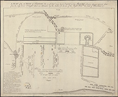
| Title: | A plan of the action at Seatowne the 21. of Septr. 1745 by an engineer ... who was present ... / (P. Fourdrinier sulp.) [By Richard Jack?] |
| Name: | Fourdrinier, Paul |
| Description: | 1 map ; 305 x 399 mm. |
| Original Survey: | 1745 |
| Date on Map: | 1745 |
| Placename: | Prestonpans |
| Parish: | Gladsmuir |
| County: | Haddingtonshire/East Lothian |
| Shelfmark: | EMS.s.162 |
| Zoom Into Map: | Click on the map to view in greater detail. |
All images © National Library of Scotland