Military Maps of Scotland (18th century)
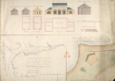
| Title: | Sketch of the River Clyde shewing the proposed situation for a Battery of nine 26 Prs. for the defence of the Harbour and Anchorage at Greenock; Plan of White Farline Point with the proposed Battery of nine 26 Prs. having a Magazine; Store House & Guard H |
| Name: | [Carmichael-]Smyth, Major [J] (Engineer) |
| Description: | 1 manuscript map ; 517 x 730 mm. |
| Original Survey: | 1813 |
| Date on Map: | 1813 |
| Placename: | Greenock |
| Parish: | Greenock |
| County: | Renfrewshire |
| Shelfmark: | MS.1650 Z.46/19 |
| Zoom Into Map: | Click on the map to view in greater detail. |
All images © Crown Copyright and © National Library of Scotland