Military Maps of Scotland (18th century)
Your search returned 4 records.
Ordered by maps relating to the whole county first, then alphabetically by parish.
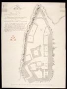
| Parish: | Carriden | |
| Title: | Plan of the Ground walls of Blackness Castle | |
| Shelfmark: | MS.1650 Z.46/61a | |
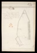
| Parish: | Carriden | |
| Title: | Plan of the Gun-ports of Blackness Castle. | |
| Shelfmark: | MS.1650 Z.46/61b | |
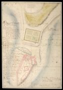
| Parish: | Carriden | |
| Title: | Plan of the Castle of Blackness [ca.1690] | |
| Name: | Dury, Theodore (Engineer) | |
| Original Survey: | [1741] | |
| Shelfmark: | MS.1647 Z.02/75a | |
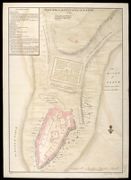
| Parish: | Carriden | |
| Title: | Plan of the Castle of Blackness [in 1690]; [copied in] 1741 | |
| Name: | Dury, Theodore (Engineer) | |
| Original Survey: | [1741] | |
| Shelfmark: | MS.1647 Z.02/75b | |