Mapmakers
Your search for Henderson returned 6 records.
Ordered chronologically (undated items first).
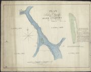
| Name: | Henderson, Andrew. | |
| Title: | Plan of Stokie Banks being part of the River Findhorn / by Andw. Henderson ... (Sinclairs lithog.). | |
| Imprint: | Edinburgh, 1823. | |
| Zoom Into Map: | Click on the map to view in greater detail. | |
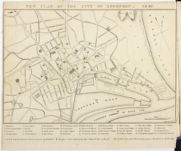
| Name: | Henderson, J. (Lithographer) | |
| Title: | New Plan of the City of Aberdeen 1840 | |
| Imprint: | [Aberdeen: Lewis Smith, 1840] | |
| Zoom Into Map: | Click on the map to view in greater detail. | |
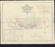
| Name: | Henderson, John | |
| Title: | Plan of part of the lands of Pitfodels in the parish of Banchory Devenick belonging to the trustees of the late John Menzies esqr. as divided for building lots, 1846 / (J. Henderson, Lithographer & Engraver). | |
| Imprint: | [Aberdeen, 1846] | |
| Zoom Into Map: | Click on the map to view in greater detail. | |
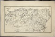
| Name: | Henderson, John. | |
| Title: | Map of the route of the Great North Railway from Aberdeen to Inverness through the intervening burgh & towns, with branches / (J. Henderson's lithography.). | |
| Imprint: | Aberdeen, [ca. 1850] | |
| Zoom Into Map: | Click on the map to view in greater detail. | |
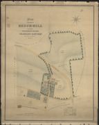
| Name: | Halkett, David Henderson | |
| Title: | Plan of the property of Beech Hill belonging to the heirs of the late Charles Hay esqr. MDCCCLII [1852]. | |
| Imprint: | MDCCCLII | |
| Zoom Into Map: | Click on the map to view in greater detail. | |
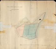
| Name: | Henderson, Peter? | |
| Title: | Plan of Arable Ground and Site of Chapel at Beoraid, North Morar | |
| Imprint: | 1889 | |
| Zoom Into Map: | Click on the map to view in greater detail. | |