Maps for Scottish local history
This resource explains some of the key kinds of maps that are useful for local history research. Maps can reveal detailed information about a local area over time, including buildings, gardens, industries, railways, roads, woodland and agricultural land. The topics below are divided by the subject and purpose of maps, including a breakdown of Ordnance Survey maps by scale (level of detail).
If you would like to use our map collections to research your own local history, you can search for digitised maps on our website, watch help videos, contact us or ask a question. You can also visit us by making an appointment to visit our Maps Reading Room in Edinburgh.
County maps
Maps that show the whole of a county, region or shire are often called county maps. They present an overview of the physical or man-made landscape of a wider region, province or administrative county.
- Before 1750, nearly all the detailed maps of counties or regions in Scotland are derived from the work of three main mapmakers:
- Timothy Pont in the late 16th century. Who was Timothy Pont?
- Robert Gordon in the mid-17th century. Who was Robert Gordon?
- John Adair in the late 17th century.
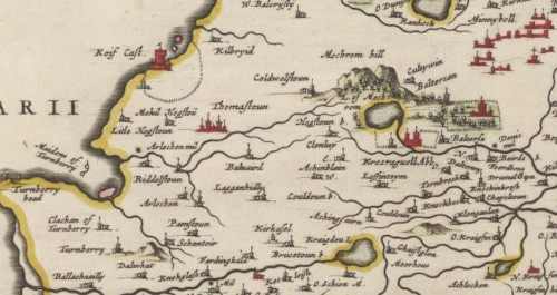
- The original survey work of Pont was the primary source behind the magnificent county maps in the first atlas of Scotland by Joan Blaeu in 1654. Who was Joan Blaeu?
- From the 1680s, John Adair was active in surveying and drafting new maps of Scottish counties, but due to financial and practical difficulties, the coverage of his surviving maps is fairly limited.
- From the 1760s, a new wave of active county map-making began, often based on an original survey, with more accurate distances and funded by subscriptions from a growing county gentry.
- Many of the lowland counties were surveyed by the early nineteenth century but often Highland counties lacked the number of subscribers needed to support a county survey.
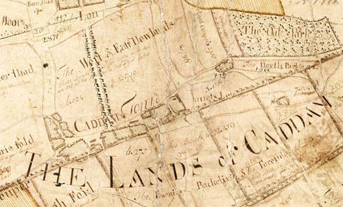
- These new county maps showed details of natural features like rivers and woodlands. They often showed industries, including quarries for coal and lime, as well as the names of hamlets and farms, sometimes for the first time.
showing roads, rivers and woodland, as well as boggy ground or moss to the north.
- In 1832, John Thomson published his monumental Atlas of Scotland, which included 58 detailed county maps. Every county in Scotland was included, even though some of the county maps were far more up-to-date than others, reflecting more recent county surveys.
- Further information on county maps of Scotland.
Estate maps
Estate maps usually very clear and detailed maps showing the grounds or territories owned by landowners and can be a useful source of local historical information, particularly of rural areas. But they do vary, and some can be a simple working outline of a field.
- Estate maps are primarily associated with the major era of agricultural improvement from around 1760 to 1840. They can illustrate all aspects of estate management including:
- Field and common land boundaries
- Drainage, embankments and areas of improved pasture or arable land created out of moss and muir
- New crops and new rotations
- Clearance of people, especially from upland areas
- The development of planned villages and new housing
- The development of new industries
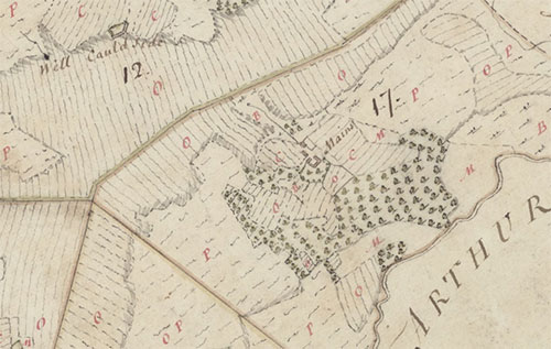
The map shows the pre-Improvement landscape (1774-5), an irregular patchwork of
O (Outfield), P (Pasture), C (Croft), M (Meadow), and B (Bog).

Note the broadly similar patterns of woodland, but with many new,
smaller and geometrically rectangular fields compared to 1774-5.
- Estate maps also illustrate profound socio-economic changes, the growing commercial use of land and resources, the expanding role of the market, all facilitated by better communications: new roads and bridges, canals, and later railways.
- Some estate maps form part of wider named estate map collections, showing different aspects of estate management over time relating to a particular estate.
- Many estate maps are in private hands or held by the National Records of Scotland. Some of these can be viewed on the ScotlandsPeople website. The National Library of Scotland's coverage of estate plans only extends over some parts of Scotland.
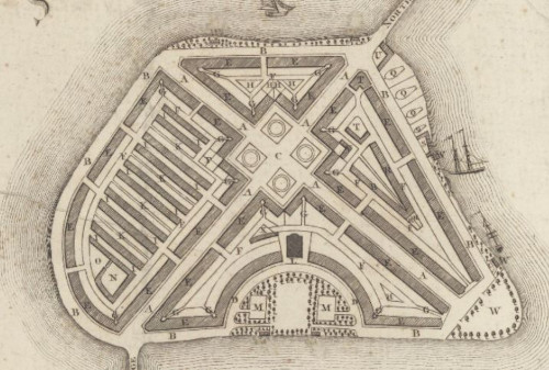
Miltary maps
Military maps are usually associated with warfare, for example showing locations suitable for attack and defence, for military purposes. They can include battle plans, plans of enemy positions, wartime land surveys, maps showing military roads and building plans of castles and forts.
- Warfare has been a primary motivation behind mapping for centuries. Some of the most important military maps of Scotland, both locally and nationally, were made for defensive and offensive military purposes.
- Scotland’s major conflicts drove the creation of large volumes of military maps including:
- English incursions into Scotland from the 15th to the 17th centuries
- The Jacobite risings in the 18th century
- The Napoleonic Wars
- The First and Second World Wars
- Early military maps often focused on the detail of particular sites, , and have value for local historical studies of these places.
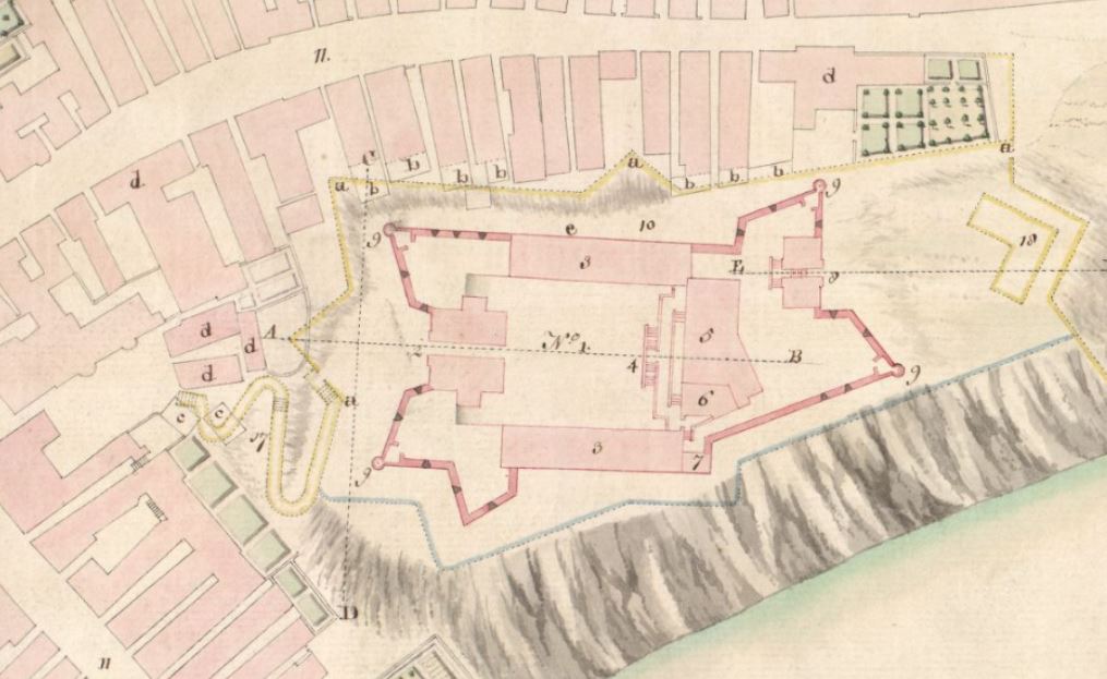
The first Fort George within Inverness was founded in 1727, named after George II,
adapting the old medieval castle in central Inverness.
- Military maps of the Board of Ordnance include the earliest detailed town plans of Perth and Inverness (ca. 1716)
- Many military maps show military roads planned under George Wade in the 1720s, as well as those under construction during the late 1740s under Wade’s successor, William Caulfeild.
- The Roy Military Survey (1747-55) is rightly well-known and a crucial map source for anyone interested in mainland Scotland in the 18th century.
- The Roy Military Survey provides a uniform graphic snapshot of the entire Scottish mainland at a time when the landscape was beginning an era of rapid change. For many Highland areas, it is the most detailed and informative map that survives for the entire 18th century. For all areas, it is the only standard topographic map prior to the Ordnance Survey mapping in the 19th century. Features of interest to an army commander, such as roads, rivers, the positions of villages and hamlets, as well as general land-cover and terrain are remarkably accurate. The designed landscapes around some of the larger country houses and estates are also particularly impressive.
- However it is important to also note:
- According to William Roy, the Roy Military Survey was a 'magnificent military sketch, [rather] than a very accurate map of the country' in which 'no geometrical exactness is to be expected, the sole object in view being, to shew remarkable things, or such as constitute the great outlines of the Country'.
- The Roy Map was the work of rapid reconnaissance rather than a carefully measured topographic survey. Many features beyond selective measured traverses — farms and houses, enclosures and woodland, as well as relief — were sketched in by eye.
- Place names are often quite variable too, sometimes reflecting local pronunciation, and recorded by surveyors who were usually unfamiliar with Gaelic or Scots.
- Further information on military maps of Scotland.
Town plans
Town plans are usually detailed maps of urban areas. They can refer to any built up settlement including cities and burghs.
- A few towns in Scotland have maps extending back over four centuries: Edinburgh and St Andrews were actively mapped from the 16th century, and Aberdeen from the mid-17th century.
- Many towns in Scotland were not first mapped until the late 18th or early 19th centuries.
- Town plans can show buildings under construction, or planned changes that never occurred to try to keep the map looking up-to-date. This is particularly true of feuing and development plans.
This impressive proposal was never implemented.
- The most significant surveyor of Scottish towns was John Wood, who published over 50 plans of Scottish towns between 1818 and 1826.
- A few of Wood’s plans were based on recent town plans by other surveyors, but many were based on original surveys by Wood himself. For many smaller Scottish towns these are the earliest plans that were created, and in addition to showing the town in good detail, many also name land and property owners.
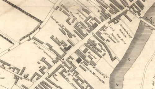
- Almost all of these plans were also published in Wood's Town Atlas of Scotland (1828). Wood’s Descriptive Account which accompanied his Town Atlas has useful written portraits of the towns too.
- Plans were published of 75 towns in Scotland in order to show new electoral boundaries for implementing the Great Reform Act (Scotland) of 1832. Further information about Great Reform Act plans.
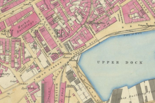
- Over 600 maps were included in Post Office Directories, which were issued for many of Scotland’s larger towns. As well as naming all streets, the Post Office Directory maps show good detail of all the built-up areas, clearly highlighting things like public buildings, churches and chapels, schools, railways, tramways, docks, harbours, public gardens and parks.
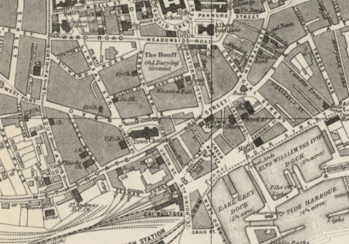
This plan can be found by searching the Town Plans listing.
- In the late 19th century, the firm of Charles Goad mapped a selection of Scottish towns in great detail for assessing fire risk. Read further information on Charles Goad and his maps.
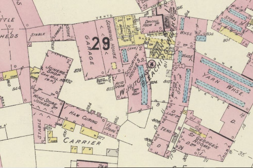
shows a corner of George Place with garages, a joiners shop and yarn warehouse labelled.
- Further information on town plans of Scotland.
Transport maps
Transport maps include more specific maps such as sea charts, road maps, canal plans, railway maps, or aeronautical charts. Engineering drawings and plans, for new routes tend to be more detailed than maps created to promote a route or to receive offical approval. Actual routes can differ from planned routes as plans were often changed, disputed or not practical. Some transport maps show details of towns and other local information such as nearby industries.
- Transport maps are particularly useful for researching the development of roads, canals, bridges, and railways from the later 18th century to the present.
- Early coastal sea charts date from the 16th century, including Dutch charts by Lucas Janszoon Waghenaer.
- Earlier charts from the 16th century tend to show less detail of the land than later 18th century charts. However, many charts include details of the coastal landscape and nearby settlements.
- Murdoch Mackenzie’s charts of Orkney (1750), for example, show inland settlements, larger houses, and churches, as well as prominent dykes or walls.
- Prominent buildings such as churches, windmills, towers, or chimneys, as well as the overall size and shape of settlements, were useful for navigation, and often shown on charts.
- Admiralty charts in the 19th and 20th centuries are often useful sources of information with details of roads, railways, bridges, and canals. Some early Admiralty charts pre-date Ordnance Survey mapping. Further information on Admiralty charts of Scotland.
- Land reclamation from the sea and other coastal change can be visibly seen by viewing charts over time.
- Further information on coastal charts of Scotland.
Ordnance Survey maps - a brief history
Ordnance Survey (OS) maps are a treasure trove of useful information to any local history researcher. As a government institution, the Ordnance Survey was able to produce hundreds of thousands of maps. These maps have been published in a wide range of scales from large scale (covering a smaller area in more detail) such as the OS Town Plans (1:500 / 1:1,056) to small scale (covering a large area in less detail) such as the OS Quarter-Inch to the mile series (1:253,440).
- The Ordnance Survey, officially founded in the 1790s, focused on mapping southern England and then Ireland first, before mapping Scotland comprehensively from the 1840s.
- Scotland was mapped, county by county, generally starting in the south-west and moving onwards to the north-east. The Ordnance Survey finished surveying the last counties, Orkney and Shetland, in 1877 to 1878. The pre-Second World War maps are often referred to as the County Series.
yellow (burnt sienna) and blue colouring used in some early OS maps.
- From 1890 to 1910, further widespread revisions at the large-scales were completed, and partial revisions of more built-up areas were continued up to the Second World War.
- From the Second World War onwards, the Ordnance Survey started surveying new maps using a new grid based system called the National Grid. The newly surveyed maps for the Highlands were not finished until 1980s. These later maps are often called the National Grid Series.
- The Ordnance Survey mapped urban areas undergoing greater change more regularly.
- For each scale of mapping, there were clear guidelines (which changed over time) on which features were to be included or ignored on the maps and on what characters and symbols would be used to represent these features.
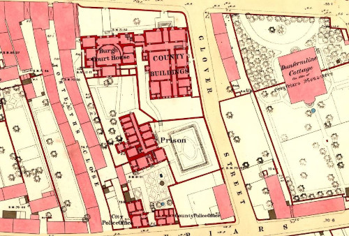
Ordnance Survey large-scale town plans
The OS town plans are highly detailed at scales of 1:500 and 1:1,056. The internal room layout of public buildings is often shown, such as the Dundee poorhouse; each room has been labelled and each window and door carefully drawn. Even the layout of the Hamilton Infantry Barracks can be seen.
- Public health concerns were the main motivation for these very detailed urban town plans. These town plans covered all settlements with more than 4,000 inhabitants.
- 59 Scottish towns were mapped between 1847 (Stranraer) and 1874 (Wick), as part of the first county map surveys. More revisions were made for fourteen towns, along with two new towns, Burntisland and Portobello. The different revisions can be compared, permitting local historians to study detailed changes over time.
- For all these towns, the Ordnance Survey has created no further large-scale maps.
- Due to the importance of the maps for improving health in towns, they show details of water taps, sewerage covers, stop-cocks, fire hydrants and ventilators.
- The maps shows walls and other divisions between all buildings, including tenements. Wynds, vennels and other narrow passageways that are a regular feature of Scottish towns, all appear on the OS town plans. This amount of detail is rarely visible on smaller scale maps.
- Many industrial premises are clearly shown, sometimes including details of their different manufacturing processes, along with harbours, docks, market places, canals, railways, and tramways.
- The maps also show the ground floor layout of public buildings, such as cathedrals, churches, schools, poorhouses, prisons, and town halls.
- After the Second World War, the Ordnance Survey published a series of 1:1250 scale maps . These are the closest scale to the older OS town plans.
- Further information about OS Town Plans.
Ordnance Survey 25 inch to the mile maps
The OS 25 inch maps cover all inhabited areas of Britain. They are a smaller scale than the Town Plans but a larger area is covered. These maps are particularly useful to local historians looking at changes in smaller settlements including changes to buildings and streets.
- The Ordnance Survey began working on the 25 inch series from 1855 onwards and this series is the earliest detailed OS mapping for all the inhabited regions of Scotland.
- All the inhabited regions of Scotland, including towns, villages and cultivated rural areas were mapped, covering over a third of the total land area of Scotland.
- The 25 inch scale is an excellent scale for exploring details of settlements including buildings, gardens, free-standing trees, railways, industrial premises (including the many water mills in Scotland), quarries, lime kilns, and docks.
- Not all sheets were coloured, but those that were coloured used:
- blue for water features.
- burnt sienna for roads.
- carmine for buildings made of brick or stone.
- grey for buildings made of wood or iron.
- The 25 inch maps record acreages of all land parcels. Land parcels were numbered in order within each parish, and acreages of fields were recorded in separate Parish Area Books or Books of Reference. For all of Scotland, apart from Orkney and Shetland, these Books of Reference include land use information.
- After the Second World War, the National Grid Series published maps at an equivalent scale (1:2500). We have added the out-of-copyright (ie. published over 50 years ago) OS 1:2500 maps of Scotland on our website. We continue to add new maps of Scotland as their copyright expires. New out-of-copyright maps are shaded orange on the Map Finder with Outlines viewer.
- Further information about OS 25 inch maps.
Ordnance Survey Six-Inch to the mile maps
The Ordnance Survey Six-inch maps cover the whole of Britain including rural and uninhabited areas. This series is popular with readers who are researching local history including topics like railway stations, local travel and changes in local industry.
- This series is the most detailed scale to cover all areas, and an excellent resource for local history research.
- Every road, railway, field, fence, wall, stream, and building is shown, even including smaller features such as letter boxes, bollards on quaysides, mile posts, and flag-staffs.
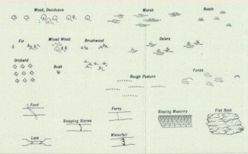
- Uncultivated land is distinguished by over 10 different symbols for types of woodland (e.g., birch, fir, mixed, furze, osier, brushwood), as well as marsh, bog, and rough grassland.
- The permanent detail of quarries, pits, slag heaps and refuse tips is shown, with the type of mineral extracted named before about 1859.
- The maps also systematically record all public boundaries, and apart from certain boundaries within towns, all administrative boundaries are clearly shown.
- A related written source that is also available online are the Object Name Books, recording the basis for the selection of place names on the six-inch maps.
- The National Grid series at 1:10,560/1:10,000 scales are the closest equivalent scale to the 6 inch to the mile sheets.
- Background essay on the OS Six-inch 1st edition maps of Scotland.
- Further information about OS Six-inch maps of Scotland (1890s-1960s).
One-inch and other smaller scales
- Ordnance Survey's one-inch to the mile (1:63,360) and smaller scale series were generalised from the larger scales listed above. These small scale maps can be used to view major change between the dates of larger-scale maps. Another use would be to compare major landscape changes such as urbanisation, changes to roads, or forestry developments.
- Three editions of engraved one-inch maps between 1843 to 1912:
- 1st edition (1856 to 1891)
- 2nd edition (1885 to circa 1903) as Outline and Hills editions
- 3rd edition (1903 to 1912) including a black outline edition and a coloured edition. Further information on OS One-inch maps of Scotland.
- Later editions followed including the full-colour Popular edition (1921 to ca.1930s) . Various military editions between 1933 and 1944 were produced (for instance the GSGS 3908 edition), before the edition with National Grid lines (1945 to 1948) and the Seventh Series (1952 to 1970). Further information on OS One-inch Seventh series maps.
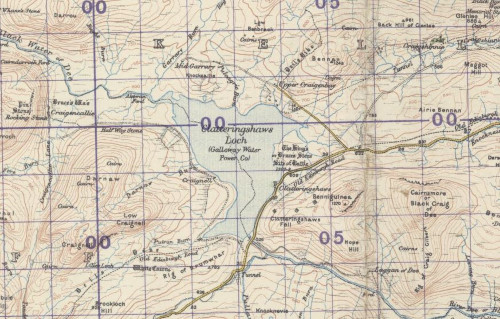
part of the Glenkens hydro-electric scheme. The power scheme did not appear on larger scale OS maps until the 1950s.
- The Ordnance Survey also published maps at half-inch and quarter-inch scales.
- The half-inch were original surveyed for miltary purposes but later editions were published for cyclists and motorists including the Ministry of Transport Road Maps (1923)
- Several different editions can be viewed on our website including two different ways of showing relief:
- During the Second World War, the Germany Army reprinted a set of half-inch maps in 1939 and 1940.
- The quarter-inch were the earliest complete series published by the Ordnance Survey. The first edition was also published in different editions including:
- Later editions of the quarter-inch include the second edition, third edition and fourth edition. Most of these editions have different publication styles too for different audiences.
Thematic maps
Ordnance Survey topographic maps were all used for creating other “thematic” maps, including maps showing geology, bathymetry, land-use, and soils.
- The Geological Survey of Scotland followed Ordnance Survey's mapping, producing attractively hand-coloured maps at the six-inch to the mile scale. As the understanding of geology developed steadily in the 19th and 20th centuries, the geological overprint became steadily more detailed and informative.
- The Bathymetrical Survey by John Murray and Laurence Pullar mapped 562 lochs on 223 detailed maps. The detailed accompanying published reports, along with the maps provide the earliest detailed analysis of Scottish lochs.
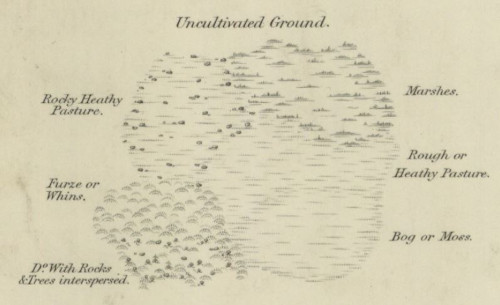
- The first comprehensive Land Utilisation Survey of Great Britain took place in the 1930s, under the superintendence of L. Dudley Stamp, publishing attractive coloured maps at one-inch to the mile scale. A second land utilisation survey was initiated in the 1960s by Dr Alice Coleman, and although unpublished, there is good coverage on 1:10,560 maps of agricultural areas in Scotland.
- The Soil Survey of Scotland, administered by the Macaulay Land Use Research Institute by Aberdeen, produced a range of soil maps at scales from 1:10,000 up to 1:250,000 between 1938 to 1986 The main output was a series of 34 maps at 1 inch to the mile (1:63,360) and seven sheets at 1:250,000 that covered the entire country.
Summary
Maps provide insights into local history in an enthralling form, but it is always important to consider the context and purpose to the maps in order to get the best out of their language and content.
Further reading
The following references relating particularly to early Scottish maps are available in many libraries:
Useful general local history resources
- The National Library of Scotland's Local History page has links to other local history resources and the Statistical Accounts for Scotland
- The Scottish Local History Forum is the umbrella organisation for all individuals and organisations interested in local history in Scotland. It also hosts the Scottish Local History Directory provides details of Scottish local history Resources and the Organisations which hold them.
Maps for local history
The following items give general guidance on using maps as historical sources for local history.
- 'Maps for the local historian: A guide to the British sources', by J B Harley, (London: The Standing Conference for Local History / National Council for Social Service, 1972).
- 'Maps and plans for the local historian and collector: A guide to the types of maps of the British Isles produced before 1914', by David Smith, (London: Batsford, 1988).
- 'Historians' guide to early British maps: A guide to the location of pre-1900 maps of the British Isles preserved in the United Kingdom and Ireland', edited by Helen Wallis and Anita McConnell, (London: Royal Historical Society, 1994).
- 'English maps: a history' by Catherine Delano-Smith and Roger Kain, (London: British Library, 1999).
- 'Scottish Local History', published 3 times a year by the Scottish Local History Forum, carries regular articles on maps.
General works on mapping
- 'Scotland: Mapping the Nation' by Christopher
Fleet, Margaret Wilkes, and Charles W J Withers, (Edinburgh:
Birlinn, in association with the National Library of Scotland,
2011).
Brings together many historic and unusual maps for the first time to demonstrate how maps reveal Scotland's history. The content is arranged thematically, and cover topics such as defence and warfare, towns and urban life, the changing countryside, travel and communications, popular culture, and mapping science. - 'Scotland: Mapping the Islands' by Christopher
Fleet, Margaret Wilkes, and Charles W J Withers, (Edinburgh:
Birlinn, in association with the National Library of Scotland,
2016).
Examines the history and geography behind the many maps of Scotland's islands. Arranged thematically, it covers topics such as population, place-names, defence, improvement, the exploitation of natural resources, navigation, and leisure and tourism. - 'Scotland: Defending the Nation', by Carolyn
Anderson and Christopher Fleet, (Edinburgh: Birlinn, in association
with the National Library of Scotland, 2018).
Explores Scotland's unique and fascinating military history, using six centuries of military maps of Scotland, from 1450 to the present day. Arranged chronologically, it discusses battle plans, roads and route-mapping, maps of castles and forts, censorship, and military mapping by the German and Russian armies. - 'The Scottish Countryside: Its Changing Face,
1700–2000' by Rosemary Gibson, (Edinburgh: John Donald in
association with the National Archives of Scotland, 2007).
Provides an excellent overview of the main categories of estate plan, the different purposes behind their creation, and their impact on the landscape. - 'The railway atlas of Scotland: two hundred years of
history in maps' by David Spaven, (Edinburgh: Birlinn in
association with the National Library of Scotland, 2015).
Showcases over 150 topographical and railway maps, telling the story of the country's railways from the early 19th century to the present day. - 'The historical cartography of Scotland: A guide to the
literature of Scottish maps and mapping prior to the Ordnance
Survey' by John N Moore. Second revised edition (O'Dell
Memorial Monography 24) (Aberdeen: Aberdeen University,
1991).
A comprehensive bibliography of writings about early Scottish maps and mapmaking.
Ordnance Survey
- 'A history of the Ordnance Survey', edited by W.A. Seymour, (London: Dawson, 1970). Available online.
- 'Old Series to Explorer: A Field Guide to the Ordnance Map' by Chris Higley, (London: Charles Close Society, 2011).
- 'Ordnance Survey Maps: a concise guide for historians' by Richard Oliver, (London: Charles Close Society, 2013).
- Charles Close Society's 'Sheetlines' Journal and Archive.
People — mapmakers, engravers and land-surveyors
- 'British Map Engravers: a dictionary of engravers,
lithographers and their principal employers to 1850', by
Laurence Worms and Ashley Baynton-Williams, (London: Rare Book
Society, 2011).
An illustrated dictionary of well over 1,500 members of the map-trade in the British Isles from the beginnings until the mid nineteenth century. - 'Dictionary of Land Surveyors and Local Map-Makers of
Great Britain and Ireland, 1530–1850', edited by Sarah
Bendall. Second edition (London: British Library, 1997).
This two-volume biographical work provides details of all the people who surveyed and made large-scale local maps in Great Britain or Ireland between 1530 and 1850.
Towns
- 'Edinburgh: Mapping the City', by C Fleet and
D MacCannell, (Edinburgh: Birlinn, in association with the National
Library of Scotland, 2014).
Examines 71 maps, dating from around 1530 to the present day, that illustrate particular themes and places in Edinburgh's history. The maps were selected for the particular stories they reveal, and the different political, commercial and social uses to which they have been put. - 'Glasgow: Mapping the City' by John Moore,
(Edinburgh: Birlinn, in association with the National Library of
Scotland, and University of Glasgow Library, 2015).
A selection of over 60 maps, plans and other images of Glasgow, dating from the late 16th century to the present, highlighting significant elements of the city's story. Maps are arranged in chronological order, and each map is accompanied by an extended essay discussing its background, key features and context. - 'Painting the town: Scottish urban history in
art', by E Pat Dennison et al., (Edinburgh: Society of
Antiquaries of Scotland, 2013).
Over 200 paintings, engravings, sketches, views and maps of 80 towns, together with expert commentary, offer a unique insight into the changing lifestyle and townscapes of Scotland.
Cartobibliographies
- 'The early maps of Scotland to 1850', edited
by D G Moir. Third edition, two volumes, (Edinburgh: Royal Scottish
Geographical Society, 1973-1983).
The most useful work on Scottish printed maps, even if rather dated today. Part history, part cartobibliography, it also lists a few manuscript maps when they are the earliest source of map information. Volume 1 summarises the mapping history of Scotland. Volume two is thematic and regional in focus. - 'Descriptive list of plans in the Scottish Record
Office' Volumes one to four, (Edinburgh: HMSO,
1966-1968).
The Scottish Record Office is now the National Records of Scotland. Later acquisitions are listed in their Annual Reports - 'The maps of Glasgow: A history and cartobibliography to 1865', by John N Moore, (Glasgow: Glasgow University Library, 1996).
- 'Constructing the military landscape: the Board of
Ordnance maps and plans of Scotland, 1689–1815' by Carolyn
J Anderson, unpublished University of Edinburgh doctoral thesis,
2010, volume two. View thesis at Edinburgh Research Archive,
A comprehensive cartobibliography of the military maps of Scotland produced in the long 18th century.
Facsimiles
- 'The Blaeu Atlas of Scotland', (Edinburgh:
Birlinn in association with the National Library of Scotland,
2006).
Full colour facsimiles of all the maps published in Joan Blaeu's Atlas novus of 1654, along with the the first translation of the Latin text into English. Includes introductory essays, and translations of the letters between Joan Blaeu and Sir John Scot of Scotstarvit (1620s-1650s). - 'The Great Map: The Military Survey of Scotland,
1747–1755', (Edinburgh: Birlinn in association with the
National Library of Scotland, 2007).
Full colour facsimile of William Roy's Military Survey of Scotland, the 'fair copy' for the north, and original protraction for the south. Introductory essays on William Roy, the military context to the survey, and on Enlightenment mapping put the work in context. - 'The Atlas of Scotland: Containing Maps of Each
County' by John Thomson, (Edinburgh: Birlinn in
association with the National Library of Scotland, 2008).
Full colour facsimile of Scotland's major folio county atlas in the early 19th century. Introductory essays describe the production of Thomson's Atlas, and the wider context of the atlas genre in the 19th century. - 'The Survey Atlas of Scotland, centenary limited
ed.', by J G Bartholomew, (Edinburgh: Birlinn in
association with The National Library of Scotland, 2012).
Full colour facsimile of Scotland's major folio atlas from a century ago. Introductory essays provide further detail on John George Bartholomew, and on the making of the Survey Atlas. - 'The Pont manuscript maps of Scotland: Sixteenth
century origins of a Blaeu atlas' by Jeffrey C Stone
(Tring: Map Collector Publications, 1989).
Includes black and white photographs of all the Pont manuscripts, with commentaries on each map. - 'The Nation Survey'd: Essays on Late Sixteenth Century
Scotland as Depicted by Timothy Pont', edited by I C
Cunningham, (East Linton: Tuckwell Press in association with the
National Library of Scotland, 2001).
Thematic chapters examine the value of the Pont manuscript maps for researching topics such as placenames, mountains, woodland, castles, and towns.
We hope you have found some of this information new and useful. If you have further suggestions or comments, please do contact us at maps@nls.uk.
View our other Research guides.