Estate Maps, 1750s-1900s
| Name: | Ross, Charles, 1722-1806 |
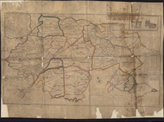
| Title: | A plan of the lands and baronys of Cessnock, Haining, Riccartoun & Galstoun &ca, which are to be sold altogether or in parcels ... / survey'd & drawn by Chas. Ross. |
| Imprint: | [S.l., 1770] |
| Pagination: | 1 map : col. ; 43 x 72 cm. |
| Shelfmark: | EMS.s.655 |
| Zoom Into Map: | Click on the map to view in greater detail. |