Estate Maps, 1750s-1900s
| Name: | Aitken, John. |
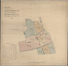
| Title: | Plan of the farm of Broomhouse, Parish of Corstorphine, Midlothian, as occupied by John Kerr ... 1877 / (John Aitken, surveyor). |
| Imprint: | Queensferry : Drawn 1877. |
| Pagination: | 1 map ; 615 x 647 mm |
| Shelfmark: | EMS.s.184 |
| Zoom Into Map: | Click on the map to view in greater detail. |