Estate Maps, 1750s-1900s

| Name: | May, Peter (ca. 1724/35 - 1795) |
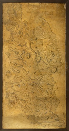
| Title: | …….Survey of Coygach ….. Parish ….part of his Majesty’s Annexed Estates ……… Cromarty North Britain. Surveyed by Pet May 1758 |
| Imprint: | Surveyed: 1758 |
| Pagination: | 1 ms. map : hand col.; 345 x 173 cm. |
| Shelfmark: | NOSAS CL.1 |
| Notes: | Scale: 1:9529. Peter May, an Aberdeenshire surveyor, was appointed by the Commissioners of the Forfeited Estates to survey the lands of the Cromartie Estate, that included Coigach, in 1756. Courtesy of the North of Scotland Archaeological Society. |
| Zoom Into Map: | Click on the map to view in greater detail. |