Estate Maps, 1750s-1900s
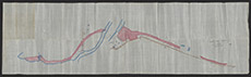

| Title: | [Railway] Plan within referred to County of Inverness United Parishes of Boleskine & Abertarff |
| Imprint: | 1906 |
| Pagination: | 1 map: col.; 38 x 138 cm. |
| Shelfmark: | Lovat389 |
| Notes: | 1:2540. (1000' = 12 cm ). Part of a disposition, kept in the Estate Office Disposition Book. This seems to show the land, coloured in pink, purchased to bring the railway line into Fort Augustus. The railway opened in 1903. Handwritten in pencil on the map: Duplicate copy of Plan signed as relative to conveyance. Courtesy of Lovat Highland Estates and the North of Scotland Archaeological Society. View Lovat Highland Estates mapping |
| Zoom Into Map: | Click on the map to view in greater detail. |