Estate Maps, 1750s-1900s
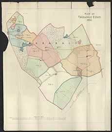

| Title: | Tarradale, 1890 |
| Imprint: | 1890 |
| Pagination: | 1 map: col.; 61 x 51 cm. |
| Shelfmark: | Lovat384 |
| Notes: | 1:7485. (80chns = 21.5 cm ). A folded map, with no surveyor or reason for being in Lovat Estate Office. Seems to show the limits of Tarradale estate, ie not the Lovat Estate.. Courtesy of Lovat Highland Estates and the North of Scotland Archaeological Society. View Lovat Highland Estates mapping |
| Zoom Into Map: | Click on the map to view in greater detail. |